


Lately, there’s been a surprising amount of talk about dedicated bus lanes and busways in Los Angeles. Metro is currently moving forward with three Bus Rapid Transit (BRT) projects: the North SFV BRT, the NoHo to Pasadena BRT, and the Vermont BRT. In 2017, Metro created a short, dedicated bus lane along Sunset Boulevard for the Dodger Stadium Express bus which many are asking to have extended along the famous street’s entire length. In 2018, Metro created a dedicated bus lane along most of Wilshire Boulevard. A few weeks ago, Metro created a short, dedicated bus lane on Flower Street in Downtown, which, according to Metro, is moving an average of 70 buses an hour and has thus far received no complaints. Campaigns are also underway to bring dedicated bus lanes to Colorado Boulevard.
Here’s an idea: why not grant dedicated bus-lanes to every length of street used by any rapid bus?
Rapid buses, in local parlance, are express buses with some characteristics of bus rapid transit. Metro launched its rapid bus service in 2000. Currently, any claims to rapidity are mostly down to the fact that they stop at fewer bus stops than do local buses and that they’re equipped with signal preemption transmitters that work within the City of Los Angeles. The primary agency responsible for rapid buses is Metro, which operates twenty lines. Big Blue Bus operates three, Culver City Bus one, and Torrance Transit one. Foothill Transit‘s Silver Streak has aspects of both BRT and Rapid Bus.
The actual rapidity of nominally rapid buses is greatly hindered by the fact that most rapid buses are currently reduced to sharing their lanes with inefficient and unsustainable private automobiles. It would be so easy to make them rapid in more than just name. Compared to other mass transit projects — the costs of which inevitably balloon past pre-project estimates — dedicated bus lanes are cheap and easy. A bit of paint, a sign, and voilà, a bus-only lane. The best part is we already have the fleet of vehicles. In other words, we don’t need to build or purchase any new equipment. We don’t need to relocate utilities. We don’t need to wait for messianic tech toffs to concoct pulp sci-fi solutions like flying Ubers or subterranean Tesla sleds. All we have to do are remove the barriers to efficiency — namely, cars.
The coverage of the Rapid Bus network itself is actually pretty good. Hollywood, Midtown, Mideast Los Angeles, South Los Angeles, and even the Westside are fairly well-served by Rapid Buses. Not surprisingly, the suburban Pomona Valley, South Bay, San Gabriel Valley, Southeast Los Angeles, and San Fernando Valley (all except the latter regions primarily served by non-Metro transit agencies) are served by far fewer if any.
The idea of a dedicated bus lane is not a new one although it’s been slow to take off in the US. The world’s first was created in Chicago in 1940. Nearly a quarter-century passed before Hamburg created the world’s second dedicated bus lane in 1963. The bus lane was a success and Germany naturally implemented dedicated bus lanes in most major cities afterward, even enshrining the concept in their highway code in 1970. Soon, Austria, Australia, Brazil, Chile, China, Colombia, Finland, France, Hong Kong, Indonesia, Ireland, Japan, Korea, New Zealand, Norway, Singapore, Spain, Taiwan, the UK, and other countries followed suit.
-

Bus lane in the middle of Roosevelt Road in Taipei, Taiwan (Photo: Howard61313)
The US has a long track record of leading the way and then watching the world pass it by. Finally, though, other American cities are implementing bus-only lanes; cities like Baltimore, Boston, Denver, Miami, Minneapolis, New York City, Pittsburgh, San Francisco, Seattle, and Washington, DC. Now, even Metro is advocating for more dedicated bus lanes.
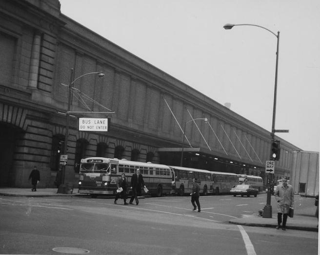
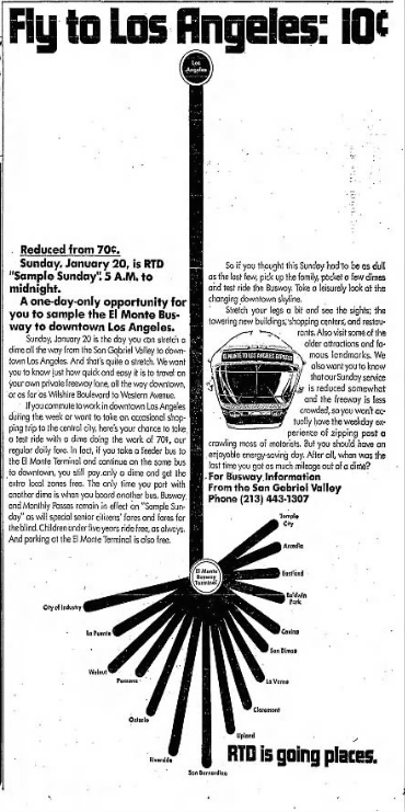 Los Angeles — which once boasted the world’s largest electric, interurban rail network — is also home to the US’s first dedicated busway. The El Monte Busway was completed in 1974. Since then, however, Los Angeles has been painfully resistant to creating a more efficient mass transit network, instead generally favoring freeway construction and road widening even over half a century’s worth of studies have conclusively proven that both actually worsen traffic (not to mention air quality and city life). Angelenos, therefore, are reduced to driving — even though most don’t want to. The more Angelenos drive, the worse the traffic and pollution. The worse the traffic, the slower the buses. The slower the buses, the more Angelenos drive. On and on it goes, like a death spiral that we could easily pull out of to the benefit of literally every living being.
Not everyone is on board with bus-only lanes. There are, of course, the notorious kneejerk NIMBYS — found in every urban center, despite their seeming distaste for every aspect of urban life. They spend what should be their golden years showing up at community meetings in order to publicly weep and gnash their teeth over any proposed improvements. For example, I once witnessed a woman cry in anguished despair over the proposal to repair crumbling roads with cool pavement. I assume that NIMBY outrage is purely performative — a type of bizarre theater — because as hard as that is to imagine, it’s easier than wrapping my head around the idea that someone could exit toddlerdom without the ability to overcome throwing public temper tantrums. The other possibility is that NIMBYs are the sort of people who actually like being upset. We’ve all known people like this — people whose days are ruined if they don’t have anything to complain about. If this latter possibility is the reality, then any attempt to appease them is a threat to the very outrage which is their essence. If their outrage is performative, we should applaud and ignore them. If it is legitimate, we should ignore them so that they can continue to nurture the outrage on which they nourish themselves.
Anyway, that Los Angeles is the nation’s most populous county and its most densely-populated metropolitan area is no secret — so no sane Angeleno imagines that the future of Los Angeles is in Mayberryization rather than Mannhattanization. Cars have no place in that future because cars belong in Mayberry and the surrounding countryside. Angelenos actually want to ride bicycles but are intimidated by the very real possibility of some mooning motorist driving into them. Angelenos want to walk but, because of cars, the air is increasingly unsafe to breathe. Angelenos want to use mass transit — provided that mass transit is properly prioritized and efficient.
It’s time everyone got on the (rapid) bus. Unfortunately, the folks at Google don’t include buses — not even BRT — on their transit tabs, even though they’ve had fourteen years to perfect their web mapping service, Google maps. This, despite the fact that buses account for 76% of Metro’s ridership and trains just 24%. Rather than show bus routes, Google tells would-be transit users who cheap climate-destroying ride-hail services are likely to be or where the nearest e-scooter is located. Then again, Google maps can’t even begin to get neighborhoods right. Of course, most of Metro’s bus stops are also notoriously bad. Most have no seating, no shelter, no lights — not to mention no system or route maps… and so it falls to me or some concerned, obsessive, enthusiast like me to create map of rapid bus routes and rail, superimposed on a map of neighborhoods.
It also falls to me or some concerned, obsessive, enthusiast like me to attempt to fashion a guide highlighting rapid bus routes. Whilst mainstream media will celebrate the inauguration of new train lines with fanfare, there is almost never any notice paid to buses.
BIG BLUE BUS RAPID 3 – LINCOLN BLVD RAPID
Big Blue Bus’s Rapid 3 line travels between Downtown Santa Monica and Aviation/LAX Station. In between, it travels through and along with the coastal communities of Venice, Marina del Rey, and Playa del Rey as well as the inland communities of Del Rey and Westchester. Depending on traffic, the entire journey usually takes between 35 minutes and an hour to complete. Much of its relative speed is owed to the fact that the city of Santa Monica gave the bus a dedicated lane along Lincoln Boulevard. However, once it enters Venice — a neighborhood of Los Angeles since 1927 — the dedicated lane ends and where it would continue, empty cars are instead parked.
Aviation/LAX Station is currently served by a free shuttle to the Los Angeles International Airport. A station even nearer the airport, Aviation/Century Station — is also the route of the Rapid 3 and is scheduled to open in 2020.
Other attractions along the line include:
- Proud Bird
- Westchester Recreation Center
- Ballona Wetlands (currently undergoing restoration)
- Marina del Rey
- A trio of British pubs (the Cock ‘n’ Bull, the Britannia, and Ye Olde King’s Head).
BIG BLUE BUS RAPID 7 – PICO BLVD RAPID

Big Blue Bus’s Rapid 7 line travels between Downtown Santa Monica and Koreatown. For nearly the entirety of its journey, it travels along Wilshire Boulevard which is blessed with a bus-only lane — except in Beverly Hills, city perversely devoted to soul-destroying gridlock. The entire journey usually takes from between forty minutes to an hour and fifteen minutes to complete. When the Purple Line (albeit with a different name) reaches the West Los Angeles VA Medical Center around 2026, it will follow roughly the same route, tunneling underneath Beverly Hills to the comical horror of many residents.
Attractions along the way include:
- Christine Emerson Park
- Douglas Park
- West Los Angeles VA Medical Center
- Los Angeles National Cemetery
- Wilshire Federal Building
- Westwood Village
- Beverly Hills’ Golden Triangle
- Beverly Hills Theater District
- Museum of Tolerance
- Cardiff Tower
- Oaxacatown
- Museum Row
- Wiltern Theatre
- Monty’s Good Burger
- CGV Cinema
BIG BLUE BUS RAPID 10 – DOWNTOWN LA FREEWAY EXPRESS
Big Blue Bus’s Rapid 10 connects Downtown Santa Monica and Union Station via the Santa Monica Freeway. With several trains and rapid bus alternatives, it’s not really among the fastest routes between those two points and most of its journey is along the 10 Freeway so most of the amenities along its route are located either in Downtown Santa Monica or Downtown Los Angeles.
They include:
- Santa Monica Public Library
- Providence Saint John’s Health Center
- Mayan Theatre
- Mikkeller Bar LA
- Bottega Louie
- REDCAT
- Music Center
- Âu Lạc LA
- Los Angeles Department of Water and Power
- Grand Park
- Los Angeles City Hall
- El Pueblo de Los Angeles
- Olvera Street
- Union Station
BIG BLUE BUS RAPID 12 – UCLA/WESTWOOD TO EXPO
Big Blue Bus’s Rapid 12 line is the shortest of that agency’s rapid buses, traveling less than seven kilometers from the border between Palms and Culver City at the southern end to the campus of University of California, Los Angeles in the north. It is somewhat interesting, too, that it’s the only of the Santa Monica-based agency’s lines which at no point passes through Santa Monica. On its short route along Overland Avenue and Westwood Boulevard, it passes through the neighborhoods of Westside Village, Ranch Park, West Los Angeles, and Tehrangeles.
Attractions it stops near along the way include:
- Scoops Westside
- Simpang Asia
- Petal House
- Vegan Joint (West LA)
- Landmark Theatre
- Ramayani
- Koutoubia
- Tehrangeles
- Hammer Museum
- Mildred E. Mathias Botanical Garden
- UCLA Meteorite Collection
- Birthplace of the Internet
- Fowler Museum
- Royce Hall
CULVER CITYBUS RAPID 6 – SEPULVEDA BLVD
Culver CityBus’s Rapid 6 line travels from Aviation/LAX Station to the campus of UCLA, primarily traveling along Sepulveda Boulevard. The 21-kilometer journey usually takes from between 45 and an hour and five minutes to complete. Along the way, it passes through the communities of Westchester, Del Rey, Culver City, Palms, Westside Village, Sawtelle, and Westwood.
Sites of note along the route include:
- Los Angeles International Airport
- Promenade at Howard Hughes Center
- Odyssey Theatre
- Samosa House
- Los Angeles National Cemetery
- Wilshire Federal Building
- Hammer Museum
- Mildred E. Mathias Botanical Garden
- The Fowler Museum
- Royce Hall
FOOTHILL TRANSIT SILVER STREAK
Foothill Transit is the primary mass transit agency serving the San Gabriel and Pomona valleys. The agency was founded in 1988. Foothill Transit launched the Silver Streak in 2007. From the Montclair Transcenter to the El Monte Bus Station, the Silver Streak travels along the San Bernardino Freeway like a rapid bus, stopping along the way only at the Pomona Transit Center and the Plaza at West Covina. From El Monte Bus Station to Downtown Los Angeles, it travels along a dedicated right-of-way, the Los Angeles Metro Busway, more like a BRT. This second section actually makes more stops, pulling up to Cal State LA, LAC+USC Medical Center, and Union Station. Finally, the final section crawls along the crowded streets of Downtown Los Angeles, like a local bus, making another dozen or so stops. Along the route, the Silver Streak passes through and by several communities without stopping in them, including East Los Angeles, City Terrace, Monterey Park, Alhambra, San Gabriel, Rosemead, Baldwin Park, Ramona, San Dimas, and Claremont.
Attractions near Silver Streak stops include:
- Flying M
- Pacific Electric Inland Empire Trail
- Glass House Pomona
- Pomona Arts Colony
- The Steps We Take
- Vamos Juntos
- El Monte Legion Stadium Nocturne
- Rio Hondo River Trail
- Luckman Fine Arts Complex
- Statue of Confucius
- LAC+USC Medical Center
- El Pueblo
- Grand Park
- Los Angeles City Hall
- Music Center
- Broad
- Museum of Contemporary Art
- Angels Flight Railway
- Pershing Square
- Mikkeller Bar LA
METRO RAPID 704
Metro’s Rapid 704 connects Downtown Santa Monica with Union Station. The trip usually takes from between an hour and fifteen minutes to an hour and a half to undertake. It mostly travels along Santa Monica and Sunset boulevards. Along the way it passes along the edge of or through the communities of Sawtelle, Westwood, West Los Angeles, Century City, Beverly Hills, West Hollywood, Central Hollywood, Theater Row, the Hollywood Media District, the Hollywood Studio District, Little Armenia, Kingsley Vista, Hel-Mel, Sunset Junctions, Silver Lake, Echo Park, Angeleno Heights, Victor Heights, Chinatown, the Civic Center, and El Pueblo.
Points of interest along the route include:
- Providence Saint John’s Health Center
- CineFile Video
- Nuart Theatre
- Beverly Gardens Park
- Little Osaka
- Troubadour
- Abbey
- Hamburger Mary’s
- Little Odessa
- Astro Burger
- Hollywood Recreation Center
- Hollywood Forever Cemetery
- Marouch
- Cahuenga Branch Library
- Bulan
- Flore Vegan
- Pine & Crane
- Silver Lake Ramen
- Osen Izakaya
- Daw Yee Myanmar Corner
- Mohawk Bend
- Elf
- Burrito King
- Echo Park Film Center
- Edendale Branch Library
- Tacos Arizas
- Kiên Giang Bakery
- El Compadre
- Guisados
- Chinatown
- El Pueblo
METRO RAPID 705
Metro’s Rapid 705 line connects the Southeast Los Angeles County “city” of Vernon with the Westside city of West Hollywood. The line began operation in 2004. The journey is usually completed in about an hour and twenty minutes. Along the way, the rapid bus travels along Vernon Avenue, La Cienega Boulevard, and several streets between. Along the way, it also passes through Central-Alameda, South Park, Vermont Square, Chesterfield Square, Angelus Mesa, Leimert Park, Crenshaw Manor, Baldwin Village, Baldwin Hills, Village Green, Cameo Plaza, (New) West Adams, Culver City‘s McManus and Hayden Tract, the Culver City Arts District, La Cienega Heights, Faircrest Heights, Crestview, Pico-Robertson, South Carthay, Beverly Hills, and Beverly Grove.
Attractions along the way include:
- Dunbar Hotel
- Leimert Park Village
- Leimert Plaza Park
- Baldwin Hills Crenshaw
- Rancho Cienega Sports Complex
- Village Green
- La Cienega Park
- West Hollywood Park
- Abbey
METRO RAPID 710
Metro’s Rapid 710 began operation in 2004. The line connects the South Bay to Koreatown. The southern terminus is a small loop around the South Bay Galleria located in Torrance at the border with Lawndale and Redondo Beach. The northern terminus is Wilshire/Western Station. Along the way it passes through Alondra Park, Gardena, Hawthorne, Lennox, Inglewood, Hyde Park, Angelus Mesa, Windsor Hills, View Park, Leimert Park, Crenshaw Manor, Jefferson Park, (New) West Adams, Wellington Square, Western Heights, Lafayette Square, Arlington Heights, Victoria Park, Oxford Square, Windsor Village, Windsor Square, Wilshire Park, and We-Wil. Attractions along the way include:
- World of Dinosaurs
- Alondra Community Regional Park
- El Camino College
- Laguna Dominguez Trail
- Crenshaw-Imperial Branch Library
- Darby Park
- Nkechi African Cafe
- Dulan’s Soul Food
- Banadir
- Veronica’s Kitchen
- Sumptuous African Restaurant
- Mr. Wisdom Specialty Health Food Store and Wheatgrass Farm
- Stuff I Eat
- Leimert Plaza Park
- Leimert Park Village
- Baldwin Hills Crenshaw
- Washington Irving Branch Library
- Crenshaw Community Garden
- Wiltern
METRO RAPID 720

Having launched in 2000, Metro’s Rapid 720 line is, along with the 750, one of the region’s two oldest Metro Rapid lines. Its eastern terminus is a shopping center in Commerce that borders the East Los Angeles neighborhood of Eastmont. The western terminus is in Downtown Santa Monica. In between it accesses the communities of Belvedere, Boyle Heights, the Arts District, the Downtown Industrial District, the Seafood District, Skid Row, the Fashion District, the Old Bank District, Gallery Row, the Broadway Theater District, the Historic Core, the Jewelry District, (New) South Park, Westlake, Koreatown, Wilshire Center, We-Wil, Wilshire Park, Windsor Park, Windsor Square, Windsor Village, Hancock Park, Brookside, Sycamore Square, Miracle Mile, Carthay Circle, Beverly Grove, Beverly Hills, Century City, Westwood, West Los Angeles VA Medical Center, Sawtelle, Brentwood, and Santa Monica. It mostly utilizes Whittier and Wilshire boulevards.
The time it takes the Rapid 720 to complete its route varies greatly. The quickest trips, take about an hour and fifteen minutes. The longest can easily take two hours and fifteen minutes.
Attractions along the route include:
- Whittier Boulevard District
- Home of Peace Memorial Park
- El Camino Real Library
- Ruben F Salazar Park
- Odd Fellows Cemetery
- Robert Louis Stevenson Branch Library
- Indie Brewing Company
- Dry River Brewing
- Institute of Contemporary Art, Los Angeles
- Superchief Gallery LA
- Cole’s
- The Last Bookstore
- Pershing Square
- Los Angeles Central Library
- Good Samaritan Hospital
- MacArthur Park
- Lafayette Park
- HMS Bounty
- Cafe Brass Monkey
- Wilshire Boulevard Temple
- The Wiltern
- CGV Cinema
- Monty’s Good Burger
- Marciano Art Foundation
- Korean Cultural Center, Los Angeles
- El Rey Theatre
- Yuko Kitchen
- Museum Row
- Beverly Hills Theater District
- Beverly Hill’s Golden Triangle
- Westwood Village
- Wilshire Federal Building
- Los Angeles National Cemetery
- The West Los Angeles VA Medical Center
- Douglas Park
- Christine Emerson Park
METRO RAPID 728
Operation of Metro’s Rapid 728 line began in 2007. It connects, at its western end, Century City with, at its eastern end, Union Station. Along the way it passes through El Pueblo, the Civic Center, the Historic Core, the Old Bank District, Gallery Row, the Fashion District, (New) South Park, Westlake, Pico-Union, Koreatown, Country Club Park, Wilshire Park, Oxford Square, Windsor Village, Olympic Park, Brookside, Longwood Highlands, Sycamore Square, Redondo-Sycamore, Miracle Mile, Wilshire Vista, Little Ethiopia, Carthay Circle, Carthay Square, South Carthay, Beverly Hills, and Pico-Robertson. The Rapid 728 mostly travels along Olympic Boulevard and the entire journey usually takes between fifty minutes and an hour and ten minutes to complete.
Attractions Metro’s Rapid 728 provides access to include:
- Union Station
- El Pueblo
- Grand Park
- Los Angeles City Hall
- The Smell
- Art Walk DTLA
- Broadway-Spring Arcade Building
- St. Vincent Court
- The Last Bookstore
- Mikkeller DTLA
- LA Live
- Loyola Law School, Los Angeles
- Song Jeho Table Tennis Club
- Guelaguetza
- Seoul International Park
- Koreatown Galleria
- Los Angeles Memorial Park and Library
- Little Ethiopia
- La Cienega Park
- Roxbury Park
METRO RAPID 733
Operation of Metro’s Rapid 733 line began in 2010. The route connects Union Station to Downtown Santa Monica mostly via Venice Boulevard. Between the two termini, the Rapid 733 passes through El Pueblo, the Civic Center, the Historic Core, the Old Bank District, Gallery Row, the Fashion District, (New) South Park, South Central, Pico-Union, the El Salvador Community Corridor, Harvard Heights, Arlington Heights, Lafayette Square, Victoria Park, Vineyard, Mid-City, Pico del Mar, Pico Park, Picfair Village, Faircrest Heights, Culver City Arts District, Palms, Culver City, and Mar Vista. A trip from end-to-end can typically take anywhere from an hour and five minutes to two twice that long — thanks to a complete lack of dedicated lanes.
Points of interest the Rapid 733 provides access to include:
- Union Station
- El Pueblo
- Triforium
- Downtown Independent
- Last Bookstore
- Localita
- California Market Center
- Angelus Rosedale Cemetery
- Normandie Recreation Center
- Kaiser Permanente West Los Angeles Medical Center
- Center for Land Use Interpretation
- Museum of Jurassic Technology
- Annapurna Cuisine
- Kirk Douglas Theatre
- Little Brazil/Pequeno Brasil
- Mar Vista Branch Library
- Venice Canals
- Venice-Abbot Kinney Memorial Branch Library
- Giant Binoculars
- Ballerina Clown
- Santa Monica Community Garden
- Tongva Park
- Ye Olde King’s Head
METRO RAPID 734
Operation of Metro’s Rapid 734 line began in 2006. The southern terminus is in the Westside neighborhood of Rancho Park. The northern terminus is in the San Fernando Valley neighborhood of Sylmar. Between the two termini, the Rapid 734 passes through West Los Angeles, Westwood, Bel Air, Brentwood, Sherman Oaks, Encino, Van Nuys, North Hills, Mission Hills, and San Fernando. The entire 38-kilometer journey takes anywhere from an hour and twenty minutes to two hours to complete.
Highlights along the way include:
- Westwood Park
- Wilshire Federal Building
- Los Angeles National Cemetery
- Hammer Museum
- Mildred E. Mathias Botanical Garden
- Schoenberg Hall
- Franklin D. Murphy Sculpture Garden
- Getty Center
- Skirball Cultural Center
- Sepulveda Basin Recreation Area
- Andres Pico Adobe
- Brand Park
- Jim’s Western Wear
METRO RAPID 740
Operation of Metro’s Rapid 740 line began in 2004. The northern terminus is located between Jefferson Park and (New) West Adams. The southern terminus is the South Bay Galleria, located in Torrance, and bordering Redondo Beach and Lawndale. In between, the Rapid 740 travels through Hawthorne, Lennox, Inglewood, Hyde Park, Angelus Mesa, Windsor Hills, View Park, Baldwin Hills, Leimert Park, and Crenshaw Manor. The route is 22-kilometer long route takes between 45 minutes and an hour to complete. The route is also covered by Metro’s Rapid 710, although that Rapid Bus continues north to Koreatown.
- World of Dinosaurs
- Alondra Park
- El Camino College (including Schauerman Library and Marsee Auditorium)
- Laguna Dominguez Trail
- Crenshaw Imperial Branch Library
- Darby Park
- Sumptuous African Restuarant
- Dulan’s Soul Food
- Banadir
- Stuff I Eat
- Mr. Wisdom Specialty Health Food Store
- Leimert Park Plaza
- Leimert Park Village
- Baldwin Hills Crenshaw (including Museum of African American Art and the annual Pan-African Film Festival)
METRO RAPID 744
Operation of Metro’s Rapid 744 line began in 2014. It is, along with Metro’s Rapid 750, one of the San Fernando Valley’s two Valley-only Rapid Bus lines. The 37.5-kilometer long route takes between an hour and ten minutes and an hour and forty minutes to undertake.
Attractions along the way include:
- Hubert H. Humphrey Memorial Recreation Center
- Tobias Avenue Park
- Plaza del Valle
- Orange Line Busway Bike Path
- Van Nuys Sherman Oaks Recreation Center
- veSTATION
- Los Encinos State Historic Park
- Reseda Park
- Los Angeles Science Fantasy Society
- Vĩnh Lợi Tofu
- California State University, Northridge
- Northridge Park
METRO RAPID 745
Operation of Metro’s Rapid 745 line began in 2002. The route connects Union Station in Downtown Los Angeles with Harbor Freeway Station, located inside the beautiful and terrible Judge Harry Pregerson Interchange. That freeway interchange is located at the border between Magnolia Square, Century Palms, and Harbor Gateway North. It runs parallel with Metro’s Silver Line, but whereas that Rapid Bus Transit travels along the Harbor Freeway, the Rapid 745 mostly travels along Broadway, and as such travels through the neighborhoods of Broadway Square, Florence, South Park, South Central, and (New) South Park, the Fashion District, the Broadway Theater District, Gallery Row, Historic Core, the Civic Center, and El Pueblo.
Attractions along the way include:
- Mercado La Paloma
- Los Amigos Mall
- Historic Street Lighting Museum
- Theater at Ace Hotel
- Orpheum
- St. Vincent Court
- Spring Street Park
- Grand Central Market
- Angels Flight
- Grand Park
- Los Angeles City Hall
- Chinatown
METRO RAPID 750
Metro launched the Rapid 750 in 2000, making it — along with the Rapid 720 — the oldest of the region’s rapid bus lines. It travels between Warner Center to Universal City/Studio City Station near the border of Universal City and Studio City. Its route runs along Ventura Boulevard, running roughly parallel to Metro’s bus rapid transit Orange Line from Canoga Station. The two lines are a study in contrasts. The Orange Line travels 21 kilometers from Canoga Station to North Hollywood Station. Since it has a dedicated right-of-way, its travel time is pretty consistently around 38 minutes. The journey of the Rapid 750 is about 23 kilometers but the line is deprived even a dedicated lane and travel times vary from an hour to an hour and fifteen minutes — nearly twice as long for a journey that’s a mere two kilometers longer. Along the way, the Rapid 750 passes through Sherman Oaks, Encino, Tarzana, and Woodland Hills.
Attractions along the way include:
- Campo de Cahuenga
- South Weddington Park
- SunCafe
- The Los Angeles River Trail
- Jinky’s Studio Café
- Los Angeles River Greenway Park
- Zev Yaroslavsky LA River Greenway
- North Valleyheart Riverwalk
- Richard Lillard Outdoor Classroom
- veSTATION
- Chimneysweep Lounge
- Los Encinos State Historic Park
- Darna in the Kineret
- Tarzana Recreation Center
- Warner Center Park
METRO RAPID 751
Operation of Metro’s Rapid 751 began in 2004. It connects the Southeast Los Angeles city of South Gate with the Northeast Los Angeles neighborhood of Cypress Park. The entire 17-kilometer journey takes any from fifty minutes to an hour and five minutes to complete. Along its journey, the Rapid 751 serves the communities of Walnut Park, Huntington Park, Vernon, Boyle Heights, and Lincoln Heights.
Points of interest along the route include:
- Sears, Roebuck & Company Mail Order Building
- Wyvernwood Garden Apartments
- Boyle Heights Sports Center & Park
- Hollenbeck Park
- Benjamin Franklin Branch Library
- Otomisan
- Al & Bea’s
- La Parrilla
- “Downtown” Boyle Heights
- Malabar Branch Library
- Hazard Recreation Center
- USC + LAC Medical Center
- Los Angeles County Coroner
- Brewery Artists Lofts
- Lincoln Heights Business District
- The fanciest El Pollo Loco
- LADWP Payment & Customer Service Center
- Lincoln Heights Branch Library
- Water Street: River of Dreams
- Footsies
- Los Angeles River Center & Gardens
METRO RAPID 754
Operations of Metro’s Rapid 754 line began in 2002. It was the first Rapid Bus with all-door boarding, in 2018, after sixteen years of forcing all riders to enter through just one of the articulated buses’ two entrances. The Rapid 754 travels between the intersection of Los Feliz, Little Armenia, and Sunset Junctions in the north; and West Athens, Athens on the Hill, and Harbor Gateway North in the south. Along the way, the line passes through Magnolia Square, Westmont, Vermont Vista, Manchester Square, Vermont-Slauson, Canterbury Knolls, Vermont Square, Exposition Park, University Park, Adams-Normandie, the El Salvador Community Corridor, Pico-Union, the Byzantine Latino Quarter, Koreatown, Little Bangladesh, Dayton Heights, Hel-Mel, and Virgil Village. The Rapid 754 travels 21 kilometers along Vermont Boulevard and takes between fifty minutes and an hour and ten minutes.
Between Hollywood Boulevard and 120th Street, the Vermont Corridor sees more than 45,000-weekday boardings and is the second busiest bus corridor in Los Angeles County. In 2017, Metro inaugurated the Vermont Bus Rapid Transit Technical Study, to study the feasibility of creating a BRT line along the corridor. The Vermont BRT is now funded and scheduled to open sometime between 2028 and 2030. After that (currently after the 2067 fiscal year), Metro will consider converting the BRT to light rail.
Sites of interest along the way include:
- Natural History Museum of Los Angeles County
- Los Angeles Memorial Coliseum
- California African American Museum
- California Science Center
- Masjid Omar Ibn al-Khattab
- University of Southern California
- Velaslavasay Panorama
- Islamic Center of Southern California
- Shatto 39 Lanes
- Shatto Park
- Bimini Slough Ecology Park
- Braille Institute-Los Angeles
- Los Angeles City College Swap Meet
- Los Angeles City College
- Hollywood Presbyterian Medical Center
- Kaiser Permanente Medical Center
- Children’s Hospital Los Angeles
- Tiki-Ti
- Vista Theatre
- Barnsdall Art Park
- Los Feliz Village
METRO RAPID 757
Operation of Metro’s Rapid 757 began in 2005. The route’s northern terminus lies at the nexus of Los Feliz, Thai Town, Franklin Village, and Little Armenia. Its southern terminus is a loop through Westmont, West Adams, Hawthorne, and Inglewood. Along its route between those termini are Gramercy Park, West Park Terrace, Morningside Circle, Manchester Square, Canterbury Knolls, Chesterfield Square, King Estates, University Exposition Park West, Jefferson Park, Adams-Normandie, West Adams Terrace, Harvard Heights, Country Club Park, Koreatown, East Hollywood, Larchmont, Melrose Hill, and the Hollywood Studio District. The length of the Rapid 757’s route is about 24 kilometers long, is mostly along Western Avenue, and takes anywhere from 45 minutes to an hour to complete.
Places of interest along the way include:
- Jesse Owens Park
- Medhani-Alem Eritrean Orthodox Tewahedo Church
- KRST Unity Center of Afrakan Spiritual Science
- Jackson Brothers Bar
- Antique Stove Heaven
- Slauson Super Mall
- Exposition Park – Dr. Mary McLeod Bethune Regional Library
- Ephemeral Views: A Visual Essay
- Harvard Yard Bar
- Koreatown Galleria
- Koreatown Plaza
- CGV Cinemas
- Monty’s Good Burger
- California Marketplace
- BiergartenLA
- Grinstein + Daniels Architects‘ Deconstructivist KFC
- Blipsy Bar
- Templo Santa Muerte
- Holy Transfiguration Russian Orthodox Church
METRO RAPID 760
Metro launched the Rapid 760 line in 2007. It connects the “new downtown” neighborhoods of Bunker Hill and the Financial District with the Southeast Los Angeles community of Lynnwood. In between, the Rapid 760 passes through South Gate, Walnut Park, Huntington Park, Vernon, the Wholesale District, the Arts District, the Downtown Industrial District, the Produce District, the Seafood District, the Fashion District, Skid Row, the Flower District, the Historic Core, Gallery Row, the Broadway Theater District, (New) South Park, the Jewelry District — as well as the eastern extremes of Westlake and Temple-Beaudry re-branded by developers as “City West.” The route is about 19 kilometers from end-to-end and takes anywhere between 45 minutes to an hour and 5 minutes.
Attractions along the way include:
- Celestial Chance
- Plaza Mexico
- Greenbar Distillery
- Santa Fe Art Colony
- Guerrilla Tacos
- Institute of Contemporary Art, Los Angeles
- St. Vincent Court
- Golden Gopher
- Seven Grand
- Âu Lạc LA
- Broad
- MOCA
- Music Center
- Grand Park
METRO RAPID 762
Metro’s Rapid 762 began operation in 2008. It is the easternmost of Metro’s north-south Rapid Bus lines, connecting Compton‘s Artesia Station in the south with Pasadena in the north. The Rapid 762 line is about 41 kilometers long and takes from between an hour and fifteen minutes to two hours to complete. Along the way, it passes through Long Beach, Paramount, South Gate, Bell Gardens, Commerce, East Los Angeles, Belvedere, Eastmont, Monterey Park, South Pasadena — and tiny slivers of Bell, Downey, and San Marino.
Points of interest along the route include:
- Crystal Casino
- Los Angeles River Trail
- Hollydale Library
- Rosewood Park
- Atlantic Avenue Park
- Atlantic Times Square
- Happy Family
- Garfield Park
- Central Park
- Kendall Alley
METRO RAPID 770
Metro’s Rapid 770 line launched in 2007. It connects Downtown Los Angeles’s (New) South Park with the El Monte Bus Station (in El Monte). In between its two termini, it passes through the Jewelry District, the Financial District, Bunker Hill, the Historic Core, the Civic Center, El Pueblo, Boyle Heights, East Los Angeles, Maravilla, Monterey Park, Rosemead, and South El Monte.
Sites of note along the route include:
- Mikkeller DTLA
- Seven Grand
- Pershing Square
- Grand Park
- Olvera Street
- Lincoln Heights Auto Glass District
- Adventist Health White Memorial
- Guisados
- La Parrilla
- George’s Burger Stand
- Evergreen Cemetery
- El Pino Famoso
- Chinese Cemetery
- El Mercado de Los Angeles
- Belvedere Community Regional Park
- East Los Angeles College
- Vincent Price Art Museum
- Yoma Myanmar
- JJ Hong Kong Café
- Veggie Life
- An Lạc Hạnh
- Thiện Tâm Vegetarian
METRO RAPID 780
Metro’s Rapid 780 line began service in 2004. Its western terminus is a small loop which passes through (New) West Adams, Mid-City, Culver City, and the Culver City Arts District (which, despite its name, is in Los Angeles, not Culver City). Its eastern terminus is a loop around the campus of Pasadena City College. In between, the 37-kilometer line runs through Faircrest Heights, Picfair Village, Little Ethiopia, Miracle Mile, Carthay Circle, Beverly Grove, Park La Brea, Fairfax, Melrose, West Hollywood, Spaulding Square, Laurel Canyon, Sunset Square, Nichols Canyon, Hollywood-Highland, Yucca Corridor, Downtown Hollywood, Franklin Village, Little Armenia, Thai Town, Los Feliz, Atwater, Glendale, and Eagle Rock.
Attractions along the way include:
- Little Ethiopia
- Museum Row
- Original Farmers Market
- Canter’s
- Little Odessa
- Moun-Of-Tunis Restaurant
- Magic Castle
- Japan House
- Egyptian Theatre
- Arena Cinelounge
- Musso & Frank
- Capitol Records
- Palms Thai
- Thai Town
- Cruzer Pizza
- Paru’s
- Honeybee Burger
- Barnsdall Art Park
- Los Feliz Village
- Griffith Park
- Los Angeles River Trail
- Bigfoot Lodge
- India Sweets & Spices
- Roost
- Tam O’Shanter
- Glendale Civic Center
- Eagle Rock Plaza (The Filipino Mall)
- Egasse-Braasch House
- The Eagle Rock
- Norton Simon Museum
- Old Town Pasadena
- USC Pacific Asia Museum
- Pasadena Playhouse
- Laemmle’s Playhouse 7
- Vroman’s Bookstore
- Canterbury Records
- Regency Academy Theater
METRO RAPID 788
Metro launched the Rapid 788 line in 2014. Its route connects the Westside in the south to the San Fernando Valley in the north which is why it’s also known as the Valley-Westside Express. However, making the entire 35-kilometer journey takes anywhere from an hour to an hour and forty minutes to make. The southern terminus is located at the edge of the communities of Sawtelle, West Los Angeles, Little Osaka, and Rancho Park. The northern terminus is located on the border between Arleta and Panorama City. In between, the Rapid 788 passes through Westwood, the West Los Angeles VA Medical Center, Brentwood, Bel Air, Encino, Sherman Oaks, and Van Nuys.
Sites of interest along the way include:
- Little Osaka
- The West Los Angeles VA Medical Center
- The Wilshire Federal Building
- Los Angeles National Cemetery
- The Getty
- The Skirball Center
- Sepulveda Basin Recreation Area
- Los Angeles Science Fantasy Society
- Tobias Avenue Park
- Plaza del Valle
METRO RAPID 794
Metro launched the Rapid 794 in 2008. The 43-kilometer long route connects the Downtown neighborhood (New) South Park with the San Fernando Valley neighborhood of Sylmar. The entire route takes anywhere between an hour and a half to two hours and five minutes to complete. Along the way, the Rapid 794 passes through the Historic Core, the Jewelry Center, the Civic Center, Chinatown, Elysian Park, Solano Canyon, Cypress Park, Glassell Park, Glendale, Burbank, Sun Valley, Pacoima, and San Fernando.
- The Historic Street Lighting Museum
- Pershing Square
- La Cita
- Grand Central Market
- Riverside Roundabout and Confluence Park
- Los Angeles River Center & Gardens
- Cypress Park
- King Taco #1
- Rio de Los Angeles State Park
- Glendale Tap
- Moonlight Rollerway
- Golden Road Brewery
- Blue Room
- Robert E. Gross Park
- Hollywood Burbank Airport (nowhere near Hollywood, by the way)
- Sun Valley Recreation Center
- Cesar E. Chavez Memorial
TORRANCE TRANSIT RAPID 3
Torrance Transit operates just one Rapid Bus line, the Rapid 3. The 28-kilometer long line connects the South Bay city of Redondo Beach with Downtown Long Beach. Along its journey, it also passes through Torrance, Harbor Gateway, West Carson, Carson, and Wilmington. The trip usually takes between an hour to an hour and 20 minutes to complete.
Site of note along the Rapid 3 route include:
- Walteria Park (and Library)
- Zamperini Field Airport
- Kaiser Permanente South Bay Medical Center
- Ken Malloy Harbor Regional Park
- Old Town Torrance
- Eastgate Plaza
- Los Angeles Harbor College
- Los Angeles River Trail
- Torrance Promenade
FURTHER READING
“Best Practices in Implementing Tactical Transit Lanes” by John Gahbauer and Juan Matute
“Want a transit system that actually works? Then L.A. needs bus-only lanes” by the Los Angeles Times Editorial Board

Eric Brightwell is an adventurer, essayist, rambler, explorer, cartographer, and guerrilla gardener who is always seeking paid writing, speaking, traveling, and art opportunities. He is not interested in generating advertorials, cranking out clickbait, or laboring away in a listicle mill “for exposure.”
Brightwell has written for Angels Walk LA, Amoeblog, Boom: A Journal of California, diaCRITICS, Hidden Los Angeles, and KCET Departures. His art has been featured by the American Institute of Architects, the Architecture & Design Museum, the Craft Contemporary, Form Follows Function, Los Angeles County Store, the book Sidewalking, Skid Row Housing Trust, and 1650 Gallery. Brightwell has been featured as subject in The Los Angeles Times, Huffington Post, Los Angeles Magazine, LAist, CurbedLA, Eastsider LA, Boing Boing, Los Angeles, I’m Yours, and on Notebook on Cities and Culture. He has been a guest speaker on KCRW‘s Which Way, LA?, at Emerson College, and the University of Southern California.
Brightwell is currently writing a book about Los Angeles and you can follow him on Ameba, Duolingo, Facebook, Goodreads, Instagram, Mubi, and Twitter.


So fabulous! Would love to ride the length of all of these!Have you done that?Liane
LikeLike
I haven’t although it sounds like a worthwhile endeavor to me!
LikeLike
I see you’re using SI (metric system) units to measure distances, even though almost everyone in the USA expresses distances in miles. The traditional units may be archaic, inefficient and out of step with the rest of the industrialized world, but they are so embedded in US culture that I will probably be “six feet under” long before the euphemism for death becomes “1.8 meters under.”
LikeLike
I realize that .13 percent of the world’s nations still use British Imperial units but I hope that most of their residents — being such a small minority — aren’t unduly troubled by the system used everywhere else. I doubt there are more than a handful of Burmese, Liberians, or Americans who convert, say, 9mm Glocks, 5k runs, and 2L sodas to .354331 inch Glocks, 3.10686 mile runs, and 0.528344 gallon sodas in order to function.
LikeLike
Yes the SI units are making inroads, but for whatever reason, folks in the US seem to be resistant to them. I wonder if there’s any connection between what we call football, and what the rest of the world calls football and we call soccer, and our staying with feet and pounds. I’ve noticed that on some of the British “police procedural” TV shows that we sometimes hear a person’s weight being so many “stone” (one “stone”=14 pounds or 6.3 kg), so old habits die hard.
LikeLike
I had never heard of the Egasse-Braasch House, but I’ll look for it next time I’m in the area (some of my musical friends have done house concerts at residences in Eagle Rock). One of the newer attractions in the area is the “5 Line Tavern” at the corner of Colorado and Caspar. The name was inspired by the streetcar line that used to end at Colorado and Eagle Rock Blvd. The 5 Line was one of the world’s longest streetcar lines and ran from Eagle Rock to Hawthorne. It was part of the Los Angeles Ry. (Yellow Car) system, and ran until 1955 or 56. Regarding the Eagle Rock itself, when my brother and I were wee lads, we had relatives who lived across the street from the eponymous rock formation, and we would climb on the rock as part of a visit. After a while, the owners fenced it off, probably fearing “attractive nuisance” laws.
LikeLiked by 1 person