

WHERE THE WEST BEGINS AND THE SUNSET ENDS — THE VALLEY


There are numerous valleys in Los Angeles County: the Antelope, Crescenta, Hungry, Peace, Pomona, Puente, San Gabriel, Santa Clara River, and Santa Clarita, to name a few of the better known ones. However, when one hears mention of The Valley it is almost universally recognized as a reference to Los Angeles County‘s San Fernando Valley.

Several regions of Los Angeles are widely mis-characterized with simple, ignorant and largely inaccurate stereotypes. Downtown is non-existant (as in “LA has no downtown”); the Eastside is a brown, gang-plagued war zone; Hollywood is home to glamorous movie stars (and all of the city’s best tourist attractions); South Los Angeles is a black, gang-plagued war zone; the Westside is all tasteless, wealthy, white, plastic people who live in gaudy mansions.
SOUTHLAND PRIMERS

Pendersleigh & Sons Cartography‘s map of LA County divided into sub-regions
The San Fernando Valley is that last region of LA County that I’ve written a primer for, with the hope that they will incite voting for more neighborhoods as well as spur readers’ own community explorations. The other primers include Angeles Forest, The Antelope Valley, Downtown, The Eastside, The Harbor, Hollywood, The Mideast Side, Midtown, Northeast LA, Northwest LA County, The Pomona Valley, The San Gabriel Valley, The Santa Monica Mountains,The South Bay, South LA’s Eastside, South LA’s Westside, Southeast LA County, The Verdugos, and The Westside. After this I will undertake a North Orange County primer and a South Orange County primer — although Orange Countians don’t seem to need encouragement in voting. Currently 38% of the neighborhoods in the Top 50 are for Orange County communities. To vote, skip to the end of this blog entry.
THE VALLEY IN THE IMAGINATION

As previously mentioned, a certain stereotype prevails of the Valley, not just amongst those who’ve never been but also of many of those who’ve had actual cause to venture there. To wit, the Valley is said to be a sprawling, smoggy suburban region inhabited by culture-less white people whose idea of culture is eating at PF Chang’s or taking in the latest franchise entry at the nearest mall’s megaplex. The Valley is also widely recognized as the porn capitol of the world — at least in terms of production (I doubt that there’s anything approaching a consensus about who makes the “best” porn).

THE VALLEY IN REALITY

The reality, as is usually the case, is somewhat different. It is true that a large percentage of American pornographic films are produced in the Valley. Much of the Valley is, in fact, suburban, although more of it has urbanized and continues to do so — often to the chagrin of former suburbanite Valley residents. Although it at once time came close to being “the white spot of America” that Los Angeles was sold as, it’s increasingly multicultural like the rest of Los Angeles. In fact, the few neighborhoods that aren’t especially diverse also happen to be minority enclaves.
The Valley’s population is far from homogeneous; its diversity isn’t that different from that of the County as a whole. 43% of Valley residents are Latino (about 5% less than the county average), 9% are Asian (about 6% below the county average), 4% are black (5% below county average). The population of non-Latino white is large (41% compared to the county’s 28%) but still neither a majority or plurality. Furthermore, the white population is highly ethnically diverse; including especially large numbers of ethnic Armenian, English, German, Irish, Italian, Jewish, Palestinian, Persian, and Russian Americans. By contrast, the Latino population is almost entirely either Mexican or Salvadoran and the Asian population overwhelmingly Korean or Filipino (although there are certainly a large number of Chinese, Thai and Vietnamese-owned businesses.
GEOGRAPHIC AND POLITICAL BOUNDARIES

Pendersleigh & Sons Cartography‘s Map of the San Fernando Valley (available on merchandise from Cal31.com)
In my experience, many Angelenos, whether living within or without the Valley, actually think that the region is neither part of Los Angeles geographically or politically. In fact, only Burbank and San Fernando (and Calabasas and Hidden Hills, if you consider them to be Valley communities even though they’re located in the Santa Monica Mountains southwest of the Valley) are their own municipalities. Historically, as with much of Los Angeles, many of the neighborhoods were once small towns that were eventually annexed by Los Angeles. There have also been numerous by Valley residents to secede from the rest of the city. If they succeeded, ironically, they would become the sixth largest city and thus, hard to swallow as a suburb.
Whatever one might think, the San Fernando Valley is still part of the City of Los Angeles. Although there’s still a distinct Valley identity (birthplace of Baskin-Robbins, Bob’s Big Boy, Du-Par’s, Gelson’s, KGIL, Vivid, Wicked Pictures, &c) a lot of energy has gone into its balkanization. West Hills seceded from Canoga Park, Sherwood Forest and Valley Village and West Toluca Lake split from North Hollywood, La Tuna Canyon disaffiliated with Sun Valley, part of Van Nuys nominally became Sherman Oaks, and Arleta wants a different zip code from Pacoima. Other communities simply changed their names. Sepulveda became North Hills, Owensmouth became Canoga Park, Toluca became Lankershim and later North Hollywood, &c. I doubt that I’m the only one that finds the efforts to disassociate a bit perplexing!

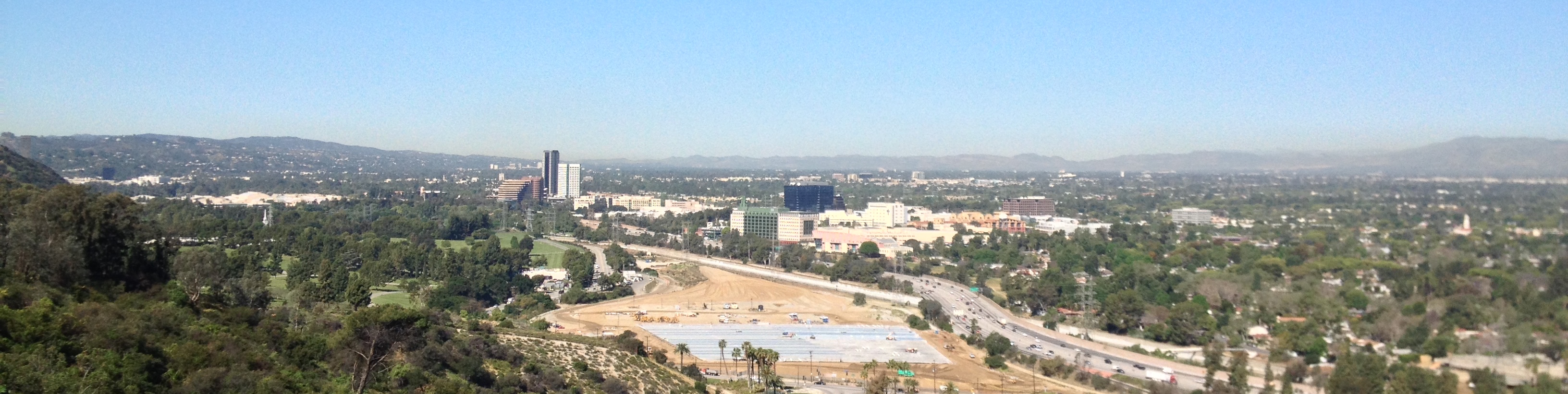
From the valley floor, it wasn’t immediately clear to me when I was in the Valley when I moved to Los Angeles in 1999. In much, maybe most, of LA, various traverse mountain ranges form the horizon and are somewhat hard to tell apart by sight alone. It was only from the top of the Hollywood Hills/Santa Monica Mountains that I could see how the 1.75 million residents of the 670 km² Valley were hemmed in by the Santa Susana Mountains, San Gabriel Mountains, Shadow Hills, Verdugo Hills, Hollywood Hills, Santa Monica Mountains, Chalk Hills, Hidden Hills, and Simi Hills.
Its neighbors that are separated from the Valley by the ranges that form its border include Northwest County (and Santa Clarita Valley) to the northwest, Angeles Forest to the northeast, The Verdugos (and Crescenta Valley) to the east, the Mideast Side and Hollywood to the southeast, the Santa Monica Mountains to the southwest, and Ventura County to the west.

HISTORY OF THE VALLEY

I think it was at 2009’s Divine Design, which I attended with artist Xu DaRocha, that I picked up a copy of Kevin Roderick‘s book, The San Fernando Valley: America’s suburb (2001), which is an enjoyable overview of SFV history. I recommend it for those who enjoy digesting history in coffee table book form. For a bit of history in blog form, let me attempt to summarize:
The Chumash, Tataviam and Tongva Period
For about 8,000 years before the Spanish Conquest, the Valley was home to the Chumash, Tataviam and Tongva nations. The Chumash were mostly settled in the hills, coast and Channel Islands to the west but traded with the Tongva at Hu’Wam, above modern day Chatsworth. The small Tataviam nation was settled along the Santa Clara River to the Valley’s northwest and the foothills of the Santa Susana Mountains. The Tongva mostly inhabited the wooded and well-watered southern margins and their villages included Kawengna, Pasakngna, Siutcanga, and Totongna. Other Tongva place names include Topanga and Tujunga.
The Spanish period


The aforementioned pornography industry arrived in the Valley in the 1970s, as mythologized in Paul Thomas Anderson‘s 1997 film, Boogie Nights. In the 1970s and ’80s, the Valley Girl subculture emerged and was lampooned by Frank Zappa in his 1982 single, “Valley Girl” and depicted in the 1983 Martha Coolidge film, Valley Girl.

Most clichés about Los Angeles and its regions tend evolve much more slowly than reality, growing increasing dissonant over the decades until they’re completely unrecognizable yet still repeated as fact. Here, then, are brief introductions to the modern communities of the Valley. I hope that readers will vote for them and that I will get to know them better.
BURBANK

Burbank is named after a dentist, Dave Burbank. In the 1930s, Lockheed moved there and became the Valley’s largest employer. One of my first jobs was working at the no longer extant Penny Lane in Old Town Burbank. Although I didn’t work there long, I ate and drank my way around the Old Town area. Along with the rest of the Rock ‘n’ Roll Monday crew, I used to go to the Blue Room not infrequently. For entertainment, I’d sometimes ride the elevators at the Holiday Inn. The population is 59% white (mostly Armenian and Iranian), 25% Latino (mostly Mexican), 9% Asian, and 2% black. To read more about Burbank, click here.
CANOGA PARK

Canoga Park was originally part of Owensmouth, founded in 1912. The name was chosen to suggest to potential buyers that it was near the mouth of the Owens River. Its name was changed to Canoga Park in 1930, because Owensmouth proved, like, totally hard to say. In 1987, residents of the western portion broke off to form West Hills and those in the eastern part formed Winnetka.
The population of what remains Canoga Park is that’s 51% Latino (mostly Mexican and Salvadoran), 31% white (mostly German), 11% Asian and 4% black. Despite being best known as a significant aerospace hub in the 1950s, it’s been mentioned on Frank Zappa’s album Joe’s Garage and Bryan Ferry‘s song, “Can’t Let Go.” I also wrote about about the neighborhood when I explored the Metro‘s Orange Line extension for KCET.
CHATSWORTH

Chatsworth was mostly rural until the 1960s and still feels like a town on the edge of the Wild West. Many westerns, including the TV series The Lone Ranger and Zorro were filmed in its movie ranches which include Iverson Movie Ranch, Spahn Movie Ranch, and Bell Moving Picture Ranch. When I wrote about it in the aforementioned KCET piece, I discovered a honky-tonk (the Cowboy Palace Saloon), a large stand of mature olive trees planted in the 19th century and other surprises.
Today the population is 66% white (mostly German and English), 14% Asian (mostly Korean and Filipino), 14% Latino and 2% black. It’s home to the large Santa Susana Pass State Park and Chatsworth Reservoir.
ENCINO

Rancho Encino was founded in 1845. Encino is home to Los Encinos State Historic Park, which is home to the Rancho’s de la Ossa adobe and other features. It’s also home to the Encino Velodrome, which opened in 1963.
Encino has the oldest population in the Valley. It’s also 80% white (mostly Russian and Iranian), 9% Latino, 5% Asian and 2% black. It’s population of Korean War veterans is amongst the county’s highest. In pop culture, I reckon, It’s still best known as the setting of the 1992 Pauly “The Weasel” Shore film, Encino Man.
GRANADA HILLS

Granada Hills was simply known as Granada in the early part of the 20th Century. The “Hills” was added around 1942. It’s the birthplace of actress Ashley Judd and was where the home in Knotts Landing is actually located. It’s home to both LA County’s only Eichler Tract (Balboa Highlands) and O’Melveny Park, the city’s second largest park (after Griffith).
The population is 56% white (mostly German), 21% Latino (mostly Mexican), 16% Asian (mostly Korean) and 3% black. If I ever live in the Valley, and living up on the 25th floor of a Warner Center commercial high rise is ruled out, then I hope I can live in Granada Hills. To read more about Granada Hills, click here (warning: it was the first neighborhood blog entry I ever wrote so may disappoint readers used to more in depth/less-jokey explorations).
LAKE BALBOA

The existence of Lake Balboa as a unique community was contested until 2006, when it finally broke away from Van Nuys. Most people would consider the large Sepulveda Dam Recreation Area (which includes Lake Balboa itself as well as Balboa Soccer Fields, Balboa Golf Course and Balboa Sports Center) to be part of the neighborhood (although some would consider them Van Nuys). The lake is surrounded by cherry blossoms and there’s also a Japanese garden called, “The Japanese Garden.” Its population is 49% white (mostly German), 34% Latino (mostly Mexican and Salvadoran), 9% Asian and 4% black.
LAKE VIEW TERRACE
[UPDATE: It was only now, in 2017, brought to my attention that the original version of this primer didn’t include a blurb for Lake View Terrace. It was merely an oversight.]
The Lake View Terrace neighborhood is located in the northeasternmost corner of the San Fernando Valley. The community received international attention when it served as the location of the 1991 beating of unarmed motorist Rodney King at the hands of four LAPD officers. The titular lake is, according to legend, the long ago dried up Holiday Lake. Lake View Terrace contains an area zoned for horsekeeping and is one of the Valley’s several remaining equestrian communities. According to the 2000 census, the population of roughly 12,000 was 53% Latino, 22% white, 17% black, 5% Asian, and 2% other race.
NOHO ARTS DISTRICT

The NoHo Arts District, though somewhat distinguished from the rest of North Hollywood by official-looking Los Angeles Department of Transportation neighborhood signs, is (I believe) generally thought of as being a district of North Hollywood (the “NoHo” of the name is, after all, derived from “North Hollywood”). Because of its stylized capitalization, I assumed it is named after Manhattan‘s SoHo neighborhood and not Westminster, England’s Soho neighborhood. It rivals Hollywood’s Theater District for for the city’s live theater spotlight and has several art galleries, museums, bars and other cultural hubs. It’s a bit of a public transportation hub as well, as both the Red and Orange lines have termini there.

Pendersleigh & Sons Cartography‘s map of the NoHo Arts District
The first map I was ever commissioned to create was of the NoHo Arts District. The cheaper (free) way for fans to get me to make maps is to vote for them by clicking here.
NORTH HILLS

North Hills was formerly known as Sepulveda – after the Sepulveda Family – a family whose importance extends back to the city of Los Angeles’s founding. in 1992, a group of residents successfully lobbied to change its name to something more forgettable and generic. At the time of writing, the highest rated neighborhood business on Yelp is a plumbing company. Its population is 57% Latino (mostly Mexican and Salvadoran), 24% white (mostly German), 12% Asian, and 5% black.
NORTH HOLLYWOOD

North Hollywood isn’t its own municipality like West Hollywood is, but it’s not really ever considered to be part of Hollywood (likeEast Hollywood is). It began as town called Toluca and was renamed Lankershim in 1896. It became North Hollywood in 1927. In 1939, in one of the first instances of a Valley neighborhood breaking off from another to distance itself from perceived negative connotations, Valley Village declared independence from North Hollywood. It is home to the NoHo Arts District. The population is 58% Latino (primarily Mexican and Salvadoran), 27% white (primarily Armenian), 6% Asian and 6% black. To read more about North Hollywood, click here.
NORTHRIDGE

Northridge is probably best known for the 1994 Northridge Earthquake (the epicenter of which later turned out to be under Reseda – but by then the name had stuck). The US Metric Association is based in Northridge, fighting the good fight against the ridiculous (and unpatriotic) British Imperial system of measurements.

It’s had several, now mostly-forgotten appellations including Northridge Village, North Los Angeles and Zelzah. In 1967, Northridge hosted the psychedelic and acid rock festival, The Fantasy Faire & Magic Festival, featuring The Doors, Jefferson Airplane, Country Joe & the Fish, The Grassroots, Canned Heat andIron Butterflytook place there, at Devonshire Downs. The population today is 50% white (mostly German), 26% Latino (mostly Mexican), 15% Asian (mostly Filipino), and 5% black.
PACOIMA

Pacoima has the youngest population in the Valley. The name is Tongva for “rushing water,” a reference to the mountain streams in the area. The racially-integrated San Fernando Gardens housing project was built there during World War II to house Lockheed employees and still stands. By 1960 it was one of the main center’s hubs of the Valley’s black population although in the 1970s it quickly grew more Latino. Today the population is 86% Latino (primarily Mexican and Salvadoran), 7% black, 5% white (primarily German) and 2% Asian.
PANORAMA CITY

Panorama City is the most densely-populated community of the Valley — it’s not called Panorama Village after all. It was the Valley’s first planned community — designed by racist industrialist Henry J. Kaiser as a self-sufficient European-American community and not a commuter bedroom community for people working in the Los Angeles basin. It’s also home to the nation’s first two-story Wal-Mart. Though Kaiser and his partners initially barred non-white Americans from living in the neighborhood, the population of their community is now only 12% white. The rest is 70% Latino (primarily Mexican and Salvadoran), 12% Asian (primarily Filipino) and 4% black.

PORTER RANCH
Porter Ranch is the wealthiest neighborhood in the Valley. The population is 61% white (mostly Armenian), 27% Asian (mostly Korean and Filipino), 8% Latino, and 2% black. It’s named after 19th century wheat farmer, Benjamin Porter. In the past, many movie stars maintained ranches there and parts of it remained largely rural into the 1980s, when many tract homes replaced the remaining wheat fields. Porter Ranch’s new suburbs were featured prominently in E.T. the Extra-terrestrial(although E.T.’s hosts’ actual home is located in Tujunga).
RESEDA

Reseda is the squarest neighborhood in the Valley – in that its borders pretty much form a perfect square that covers 15 km². It was founded in 1912 as Rancho Marian – after Marian Otis Chandler, daughter of LA Times publisher Harrison Gray Otis. Naturally it was later renamed Reseda after the North AfricanReseda odorata plant, commonly known as “garden mignonette.”
Reseda’s population breaks down thus: 44% Latino (mostly Mexican and Salvadoran), 37% white (mostly German), 11% Asian, and 4% black. In film it’s been depicted as the home of xenophobic bullies both in Karate Kid and Tuff Turf. Both concern new arrivals from the East Coast who are harangued by Resedan teens and both prominently feature characters with feathered hair.
SAN FERNANDO

San Fernando is named after the mission — Mission San Fernando Rey de España which is now a museum. It also served as the interior of the Alamo in Pee-Wee’s Big Adventure. [spoiler alert: there’s no basement in the mission either].
http://static.movieclips.com/embedplayer.swf?shortid=x3mS
I’m pretty sure that San Fernando is the only city in Los Angeles County entirely surrounded by the city of Los Angeles — a sort of San Marino (the republic, not the city in LA County) to LA’sItaly. The first time I discovered San Fernando I wanted to take a vacation there and send postcards to my friends in Los Angeles. I also used to buy Levi’s and Wrangler western pants there at Jim’s Western Wear. The population of San Fernando is the least diverse in the Valley: 90% Latino (primarily Mexican and Salvadoran) and 8% white.
SHADOW HILLS

The spookily-named Shadow Hills is the least-densely populated community in the Valley (or really, the shadowy hills above it). The Shadow Hills Property Owners Association in the 1960s to fight the planned routing of an off-ramp of the 210 Freeway through the community, which has helped preserve the rural character of this largely equestrian-zoned community. The population, just over 14,000, is 59% white (mostly German), 29% Latino (mostly Mexican), 7% Asian and 1% black.
SHERMAN VILLAGE

Sherman Village is a wee and obscure neighborhood in the Valley. On Foursquare, it has only been checked into by two people. It broke off from Valley Village which itself broke off from North Hollywood. It was created in 1993 after Valley Village broke off from North Hollywood, leaving a small neighborhood cut off from North Hollywood by the 101 and Valley Village by the Tujunga Wash. It’s home to restaurant, Hugo’s, as well as two gas stations and the Best Western Mikado, a hotel and restaurant that is the oldest Japanese eatery in the Valley.
SHERWOOD FOREST
Sherwood Forest (bounded by Nordhoff Street, Balboa Boulevard, Lindley Avenue and the Southern Pacific railroad). The name was originally applied to a tract and discarded once it served its purpose — selling homes. It’s famous as the location of the late, great Richard Pryor‘s freebase-fueled self immolation.
STUDIO CITY

Studio City is situated on the former site of the town of Laurelwood. Mack Sennett began building a studio there in 1927. When other studios followed, it came to be known as Studio City. In 1955, its First Station 78 became the city’s first integrated one. Nowadays it remains largely devoted to various studios and thus has some of the lowest residential density in the city. The population that does live there is roughly 78% white (mostly German, Russian, Iranian and English), 9% Latino, 5% Asian, and 4% black.
SUN VALLEY

Sun Valley was known in the 1880s as Roberts, after a local shop. In 1896 it officially became known as Roscoe, although explanations as to why vary. It’s name was again changed, this time to Sun Valley, in 1948. It is home to The Theodore Payne Foundation for Wildflowers and Native Plants. It is also where former Bomp!Records employee Lisa Fancher launched Frontier Records. The population is 69% white (mostly Armenian), 18% Latino (mostly Mexican and Salvadoran), 8% Asian and 2% white.
SYLMAR

Sylmar is the northernmost neighborhood in Los Angeles. It was formerly a hotbed of Southern California olive production. It’s named after Sylmar Packing (formerly Tyler Olives). In 1971, the Sylmar Earthquake occurred and caused a methane explosion in a water tunnel that killed 17. The tunnel was subsequently abandoned. The population today is 70% Latino (mostly Mexican and Salvadoran), 21% white (mostly German), 4% black, and 3% Asian.
TARZANA

Tarzana is located on the former site of Tarzana Ranch, owned by Tarzan author Edgar Rice Burroughs. Nowadays it’s home to a couple of county club/golf courses and a population that’s 71% white (mostly Persian and Russian), 15% Latino (mostly Mexican), 5% Asian, and 4% black. Its Portola Middle School was used as a filming location for the films The Karate Kid, Thirteen, and Akeelah and the Bee. If you’re a Sunset Strip refugee/ex-hairmetaler or just a fan, you need to check out Paladino’s.
TOLUCA LAKE

Toluca Lake is a tiny neighborhood that began as Forman Toluca Ranch. It straddles both a portion of the city of Burbank and the city of Los Angeles neighborhood, North Hollywood. It used to be part of the town of Lankershim. “Toluca” means “beautiful valley” in Paiute. The Our Gang film, Three men in a tub (1938) was filmed on the neighborhood’s titular lake. The population is 72% white (primarily German and Irish), 14% Latino (primarily Mexican), 5% black and 5% Asian (primarily Filipino).
TOLUCA TERRACE
TOLUCA WOODS
UNIVERSAL CITY

Universal City is a community owned by Universal Studios. Located within it is the Universal Studios Hollywood theme park; the Universal CityWalk outdoor mall; the Gibson Amphitheatre; and Universal Studios’ studios, sets and back lots. Carl Laemmle opened Second Universal City on 15 March, 1915. There are no homes and no residences in the purely commercial community.
VALLEY GLEN
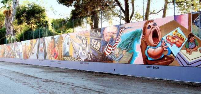
Valley Glen is a community in the San Fernando Valley which covers 12.5 square kilometers. About 49% the neighborhood’s residents are foreign born, primarily in either Mexico or Armenia. Its borders are formed by Raymer and Vanowen streets, Sherman Way, Woodman and Hazeltine avenues, Burbank Boulevard, the Hollywood Freeway, and the Tujunga Wash (which also bisects the community). The community is home to Valley Glen Community Park (formerly Erwin Park), Los Angeles Valley College, and the .8 kilometer long Great Wall of Los Angeles mural, designed by Judy Baca and painted in 1978. The website Walkscore assigns Greater Valley Glen a walkscore of 66, a bike score of 59, and transit score of just 45.
VALLEY VILLAGE

The neighborhood of Valley Village was officially recognized in 1991, after it seceded from North Hollywood (although supposedly there was a separate Valley Village community in the minds of its residents as far back as the 1930s). The population is about 67% white (primarily Russian and German), 19% Latino (primarily Mexican and Salvadoran), 6% black and 4% Asian.
VAN NUYS

Van Nuys – named after Dutch-American rancher Isaac Van Nuys — is the most working class neighborhood in the Valley. The community celebrated a grand opening celebration on Washington’s Birthday, with a grill-out, in 1911. In 1993 and 2009, parts of southern Van Nuys “became” part of Sherman Oaks, to the south. In 2004, the Valley’s firstHistoric Preservation Overlay Zone was established in Van Nuys. The population today is 61% Latino, 23% white, 6% Asian, and 6% black.
WARNER CENTER

Warner Center is a romantic, edge city first dreamt up in the 1970s and completed in the 1990s. Its dramatic skyline is formed by three not-very-tall skyscrapers that nonetheless rise above the surrounding low-rises like a theme-park version of a downtown. It’s named after Harry Warner of Warner Brothers Studios and served by the Metro’s Orange Line.
WEST HILLS

West Hills is a wealthy neighborhood where several of the headwaters for the LA River are. It was part of Canoga Park until 1987, when the mostly wealthier residents of the western portion voted to break off and form their own community (as did Canoga Park’s eastern portion – to form Winnetka).The population is 71% white (mostly German, Italian and Persian), 11% Asian (mostly Filipino), 11% Latino, and 3% black.
WEST TOLUCA LAKE
WINNETKA

Winnetka was formed in 1987 when residents of eastern Canoga Park voted to form their own community. Its name comes from the Winnetka Poultry Colony, which was itself named after Winnetka, Illinois. With a population that is 41% Latino (mostly Mexican), 36% white (mostly German), 16% Asian (mostly Filipino) and 4% black; Winnetka is the most diverse community in the Valley.
WOODLAND HILLS

Woodland Hills came into existence in 1941. The current population is 78% white (mostly Persian, German and English), 8% Latino, 7% Asian, and 3% black. According to Wikipedia, “The region is recognized for having the warmest weather in the City of Los Angeles. [citation needed]”. It is true that the highest temperature ever recorded in Los Angeles County was recorded in Woodland Hills. In July 2006 Los Angeles Pierce College recorded a temperature of 48 °C (119 °F).
So there you have it. Should you like me to explore any communities of the San Fernando Valley, please let me know in the comments.

Eric Brightwell is an adventurer, essayist, rambler, explorer, cartographer, and guerrilla gardener who is always seeking paid writing, speaking, traveling, and art opportunities. He is not interested in generating advertorials, cranking out clickbait, or laboring away in a listicle mill “for exposure.”
Brightwell has written for Angels Walk LA, Amoeblog, Boom: A Journal of California, diaCRITICS, Hidden Los Angeles, and KCET Departures. His art has been featured by the American Institute of Architects, the Architecture & Design Museum, the Craft Contemporary, Form Follows Function, Los Angeles County Store, the book Sidewalking, Skid Row Housing Trust, and 1650 Gallery. Brightwell has been featured as subject in TheLos Angeles Times, Huffington Post, Los Angeles Magazine, LAist, CurbedLA, Eastsider LA, Boing Boing, Los Angeles, I’m Yours, and on Notebook on Cities and Culture. He has been a guest speaker on KCRW‘s Which Way, LA?, at Emerson College, and the University of Southern California.
Brightwell is currently writing a book about Los Angeles and you can follow him on Ameba, Duolingo, Facebook, Goodreads, Instagram, Mubi, and Twitter.


106 thoughts on “California Fool’s Gold — A San Fernando Valley Primer”