

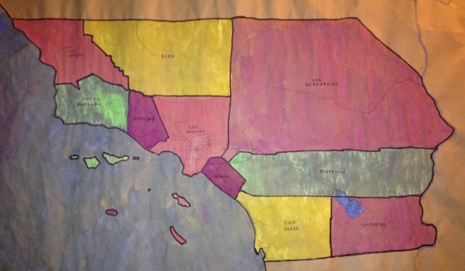
There is no official definition of what comprises Southern California but there’s certainly something like a general consensus that the region includes the ten southern-most counties in the state: Kern, Imperial, Los Angeles, Orange, Riverside, San Bernardino, San Diego, San Luis Obispo, Santa Barbara, and Ventura counties. By this definition, its northern border neatly formed by the 35° 47′ 28″ north latitude. The eastern border is formed by the Colorado River. The southern border is the international border with Mexico. To the west (and surrounding the Channel Islands) is the Pacific Ocean.
Southern California is 146,366 square kilometers in area, making it larger than Tajikistan, Somaliland, Greece, Nicaragua, North Korea, and about 150 other countries and dependencies. As of 2010, Southern California has a population of 22.68 million, making it more populous than Ivory Coast, Madagascar, Sri Lanka, Niger, Romania, and about 190 other countries and dependencies. It’s home to the most populous county in the USA, Los Angeles County, the largest county in the country by area, San Bernardino, and the most densely-populated urban area in the country, The Los Angeles-Long Beach-Anaheim area.
By most measures, Southern California is one of, if not the most, diverse regions in the world. The landscape includes large urban centers, ocean, islands, rivers, wetlands, coastal shoreline, grasslands, plains, chaparral, beaches, forests, mountains, valley, deserts, ghost towns, small towns, and suburbs. Southern California is a biodiversity hot spot, both human and non-human. I started exploring and writing about communities of Los Angeles in 2007. In 2010 I opened up my explorations to Orange County. In 2015 I opened up my explorations to the other eight counties of Southern California, writing primers for each to encourage readers to vote for as many communities as theyr’e interested in seeing me explore. And now, here are brief descriptions of each of the counties, to further guide your votes and to gather them all into one place.
*****
IMPERIAL

Imperial County holds the distinction of being the first Southern California County in the alphabet. Established in 1907, Imperial County is also the youngest county in the state. Along with San Diego County it forms the state’s Southern Border region. It’s dominated by desert but nonetheless heavily dependent on agriculture — something made possible by irrigation canals which drain the Colorado River. Its county seat and largest city is El Centro. To read the Imperial County primer, click here. To vote for Imperial County communities to be explored, click here.
KERN

Kern County is located in the southern end of California’s Central Valley. Its dominated by chaparral and its economy is largely based on petroleum extraction, the aerospace and defense industries, and agriculture.Its largest city and county seat is Bakersfield, the “Bakersfield Sound” of which is known to any country music fan with taste. To read the Kern County primer, click here. To vote for Kern County communities to be explored, click here.
LOS ANGELES
Not only is Los Angeles the most populous county in the US but its population is larger than that of 43 states! It includes two offshore islands, San Clemente and Santa Catalina, which are frequently excluded from maps or given the Alaska-and-Hawaii treatment. Spread across mountains and valleys, Los Angeles has largest elevation difference of any city in the world and by most measures is the most diverse city in the world (and thus the known universe). To vote for Los Angeles County communities to be explored, click here. To vote for Los Angeles neighborhoods, click here.
ORANGE
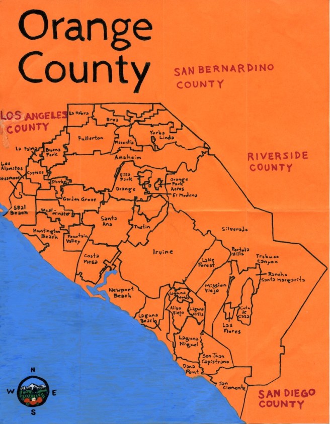
Orange County is the second most densely populated county in the state, second only to much San Francisco County (which is only 5% the size of Orange). It’s often divided into two regions, North and South County. North County is, like Los Angeles, highly diverse and home to several ethnic enclaves including Little Arabia, Little Saigon, and Little Seoul, and two of the county’s largest cities — Anaheim and Santa Ana. To read the North Orange County primer, click here. South County is generally more rural and suburban than the north but is home to county’s second largest city, Irvine, which is more interesting than it’s greige, two-story surface suggests (and despite the best efforts of its planners). To read the South County primer, click here. To vote for Orange County communities, click here.
RIVERSIDE

Riverside County, along with San Bernardino County, comprises the Inland Empire region. The most populous city and county seat is Riverside, which has a large number of historically significant buildings. It’s also known for its many desert resort cities, most famous among them, Palm Springs. To read the Riverside County primer, click here. To vote for Riverside County communities, click here.
SAN BERNARDINO
At 52,070 square kilometers, San Bernardino is the largest county in the US. Its most populous city and county seat is San Bernardino — a troubled city which (before Detroit followed suit) was the largest city in the country to declare bankruptcy. To read the San Bernardino County Primer, click here. To vote for San Bernardino County communities, click here.
SAN DIEGO

San Diego is the fifth most populous county in the US and the second most in California. Along with Imperial County it forms the states Southern Border Region. Its county seat is San Diego, the second most populous city in the state, and one of only three with a population of over one million (the other being San Jose). To read the San Diego Primer, click here. To vote for San Diego County communities, click here. To vote for the neighborhoods of the city of San Diego, click here.
SAN LUIS OBISPO

San Luis Obispo County is located on Calfornia’s Central Coast. Its county seat and most populous city is San Luis Obispo. It’s the largest wine producer in Southern California but it’s main agricultural product is strawberries. To read the San Luis Obispo Primer, click here. To vote for San Luis Obispo County communities, click here.
SANTA BARBARA

Santa Barbara County’s also located in the Central Coast. Its most populous city is Santa Maria. Its county seat is Santa Barbara. It is a prominent viticultural region with a large tourist economy. To read the Santa Barbara County Primer, click here. To vote for Santa Barbara County communities, click here.
VENTURA
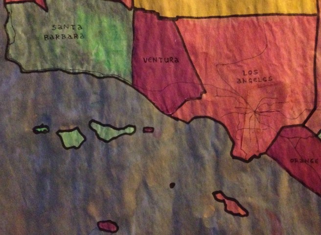
Ventura County is also located on California’s Central Coast. Its most populous city is Oxnard but its county seat is the city of Ventura. It is sometimes divided into two regions, East and West county and characterized by small, coastal towns and a few, smaller urban area. To read the Ventura County Primer, click here. To vote for Ventura County communities, click here.
*****
Eric Brightwell is an adventurer, writer, rambler, explorer, cartographer, and guerrilla gardener who is always seeking writing, speaking, traveling, and art opportunities — or salaried work. He is not interested in writing advertorials, clickbait, listicles, or other 21st century varieties of spam. Brightwell’s written work has appeared in Amoeblog, diaCRITICS, and KCET Departures. His work has been featured by the American Institute of Architects, the Architecture & Design Museum, the Craft & Folk Art Museum, Form Follows Function, Los Angeles County Store, Skid Row Housing Trust, and 1650 Gallery. Brightwell has been featured in the Los Angeles Times, Huffington Post, Los Angeles Magazine, LAist, Eastsider LA, Boing Boing, Los Angeles, I’m Yours, and on Notebook on Cities and Culture. He has been a guest speaker on KCRW‘s Which Way, LA? and at Emerson College. Art prints of his maps are available from 1650 Gallery and on other products from Cal31. He is currently writing a book about Los Angeles and you can follow him on Facebook, Instagram, and Twitter.
Click here to offer financial support and thank you!

