

GRIFFITH PARK DRIVE CLOSURE IN GRIFFITH PARK
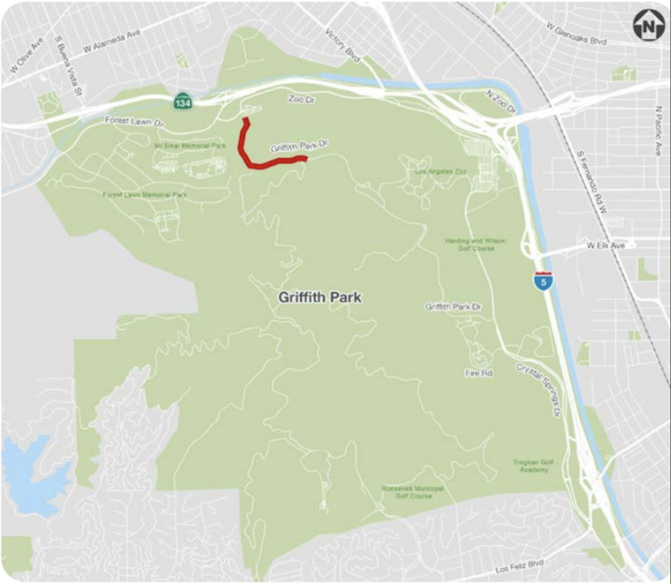
On 27 June, a small stretch of Griffith Park Drive is being closed to cars as part of a pilot program [UPDATE: It’s permanent now]. Inevitably, there were the NIMPS (Not In My Parking Spaces) who cried that they and people like them would no longer be able to visit the park. First of all, I get that not everyone is physically able to walk, bike, or stroll to a park. Nor does every Angeleno own a horse with which to ride into the park. However — this is Griffith Park — which is actually served by accessible buses and shuttles, too. Are there people who are physically able to drive to and enjoy a park but somehow not physically able to ride a bus or is this, dare I say, a bad faith argument? Furthermore, it’s less than one mile of a single street being closed for less than three months. There are still over twenty miles of roads open to private cars inside Griffith Park (and about 7,500 other miles of street in Los Angeles to befoul). Why do NIMPS need access to this particular stretch of Griffith Park Drive? Did they make plans months ago to hike Toyon Trail with P22? If so, presumably they can still walk to and from it. Personally, I don’t think that parks should allow cars inside of them at all* Cars kind of ruin the whole park-going experience. There are still … miles of streets inside of Griffith Park on which cars can drive (and occasionally kill), … acres of parking spots… and interstate freeway off-ramps and on-ramps that serve the Golden State Freeway — the existence of which cuts off park access from the Los Angeles River.
PARKS AND PARKING
Besides, there are tons of parks you can drive not just to but in. Elysian Park, the city’s oldest of any size, opened in 1886. 136 years later, no politician has found the political will to even put a bus stop inside of it — or sidewalks along most of the wide freeway-like roads that slice through it. Grand Park, “the park for everyone” is sliced into three pieces by streets, requiring park-goers to hit beg buttons like lab mice just to walk its modest length. And naturally, it sits on top of a parking garage for those unwilling, unable, or ignorant of the subway station and bus stops that flank it. Ernest E. Debs Regional Park, Sepulveda Basin Recreation Area, Hansen Dam Recreation Area, Whittier Narrows Regional Recreation Area, and O’Melveny Park (to name just a few large parks) have all got acres of parking lot for the dependent park-goer to enjoy. In fact, you can drive to and park in almost any park. Sadly, though, if want to enjoy the Channel Islands, you will have to summon the willpower necessary to pry yourself out of your cherished automobile and onto a ferry which you can tell yourself isn’t public transit if doing so makes you feel better about yourself.
MORE CARS MORE PROBLEMS

According to the Trust for Public Land, the City of Los Angeles has 646 parks, which occupy 13% of the city’s area. According to the Los Angeles Department of Transportation, streets occupy 15% of the city and are “our largest public asset.” While it’s obvious to all that parks are public assets, we tend to think of streets differently — viewing them as spaces designed primarily to convey privately owned vehicles. Trying to claim any space on a street for anything but private automobiles is inevitably a struggle.
100 years of evidence has conclusively shown that prioritizing cars leads more people to drive which leads, inevitably to worse traffic — and yet we continue to shave away sidewalks and widen freeways hoping, somehow, that it will make things better — like someone hoping to lose weight telling themselves that the only way to do so is by loosening their belt. Dedicated bus lanes, which would allow buses to transport Angelenos more effectively, affordably, and sustainably are given less priority than the storage of empty, private automobiles — which we euphemistically and perversely refer to as “parking.” The city councilperson who dares to give bicycles a seat at the table by creating bicycle lanes will inevitably face a recall while their corrupt regressive counterparts have only FBI indictments to fear. There are all kinds of other things we could be doing with our streets that would benefit us, including installing planted medians, daylighting streams, creating bioswales, giving more space to street trees, widening sidewalks, and creating parklets. And yet, for the most part, we don’t. We squeeze ten lanes for cars into city streets and then complain about how bad traffic is and how much it sucks that you have to drive everywhere and how hard it is to find parking.
A 2010 study by the Journal of the American Planning Association estimated that there are 18.6 million parking spaces in Los Angeles County. That’s about 3.3 spaces (or 1,000 square feet) for every car — or about twice the size of a small apartment. Another way to look at it is that there are over 200 square miles of lifeless, heat-radiating asphalt and concrete poured for automobiles in Los Angeles. Were they to morph into one giant hellscape, it would be bigger than the cities of New Orleans, Denver, Las Vegas, or Philadelphia — a parking necropolis for lifeless cars. Building housing is both a geometric and economic challenge; namely, you can’t build affordable housing for both people and cars. Los Angeles decided in the 1930s to require that new residential buildings include parking spots — killing off our famed bungalow courts. In the wake of Plessy v. Ferguson, which abolished racist housing covenants, Los Angeles downzoned from a potential population of 10 million to 4 million, replacing racial segregation with economic segregation. One of the results is that he have more space than is needed for cars and less than is needed for people and today more than 16,000 Angelenos live in their cars — although it’s illegal to do so. The law requires that privately owned cars stored in public spaces serve no one except for the 10% of the time they’re being driven.
LOS ANGELES’S PRE-CAR STREETS
It’s often said that Los Angeles was built around the car but, in fact, it was not always like this. Los Angeles expanded around the largest electric interurban rail network the world has ever known, the Pacific Electric Railway. Street improvements were often pushed by clubs of “wheelmen,” as cyclists were commonly known. About 200 walk streets, stair streets, and public stairways were built for the pedestrian. For its first 116 years, Los Angeles streets were entirely free of cars — or, at least, privately owned automobiles. They were used by horse-or-mule-drawn streetcars, electric streetcars, horse-drawn carriages, bicycles, and pedestrians. They were used, not just to get from one point to another, though. Kids played in them. People socialized with neighbors in them. Cities lived in them.
CARS ARE COUNTRY
Whether or not we admit it, all of us know in our bones that cars, while a practical necessity for most in the rural countryside, are annoying inside suburbs and cities. For their first three decades, cars were widely regarded as playthings for toffs or tools for farmers. Iowa — the nation’s leader in corn and soybean production — was the automobile capital of the US until 1916. And yet most of us feel trapped in an automotive arms race in which no one wants to be the first to stand down. No one thinks that Disneyland‘s Main Street, U.S.A. would be more appealing if it had some diagonal on-street parking. No one thinks that the best way to experience Descanso Gardens would be by driving along a highway through them. No one is fighting to allow cars to drive onto beaches. No one is clamoring to make way for a parade of ostentatious SUVs on Santee Alley or through Chinatown‘s Central Plaza.

The audience watching L.A. Story laughs when Steve Martin‘s character nonchalantly drives through yards, across the Los Angeles River, and down the Marathon Stairway because they understand that it’s satire — and hardly subtle at that. Since the 1980s, the taste for car-free indoor malls surrounded by vast seas of parking has given way to car-free kitschy outdoor shopping centers like Two Rodeo, The Grove, Atlantic Times Square, and the Westfield Topanga & The Village… more often than not located next to or above a vast, multi-story parking garage. In all of them, though, walking is part of the fun once you’ve freed yourself from your car. Sometimes, as with The Americana, visitors stand in line to ride trolleys that don’t go anywhere. Free public transit. So close.
Most of us would prefer to walk or ride a bike sometimes but it doesn’t feel safe to do so — so we buy cars to protect us from other cars and other drivers drive cars to protect themselves from us. We’d take the bus or train but they’re too slow because they’re stuck behind other people’s cars — so we drive cars which slow down trains and buses and cars even more. Most of us self-identify as good drivers but are baffled and annoyed by all other drivers. We refer to them, inevitably, as “idiot,” “asshole,” or if we’re in a bad mood, something unkind. We don’t want to admit that we’re part of the problem in this ridiculous arms race. We complain about being stuck in traffic, after all, and rarely if ever admit that we are the traffic.
RECLAIMING STREETS FOR PEOPLE
As much as we might want to reclaim some of our streets for people, can often feel like a hopeless task as putting a djinn back in a bottle — or worse — un-ringing a bell… and yet Los Angeles has a long history of reclaiming streets from cars. Bicycle lanes, bus lanes, and parklets are growing in number, albeit at a glacial pace. Open streets events (e.g. Arroyo Fest, CicLAvia, COAST, Re:Imagine Garden Grove, 626 Golden Streets, SOMOS, VivaSGV, &c) grow in number and popularity, too, providing a glimpse of what car-free streets could look like. Streets are increasingly closed for farmers’ markets. The city has a Slow Streets program. We can look to other cities, too, like Paris, where they abolished 72% of their on-street parking, or Barcelona, where ambitious superillas have transformed Europe’s smog and noise capital into something much more pleasant, or Seoul, where its freeway-to-park conversion, Seoullo 7017, and the daylit stream, the Cheonggyecheon. But we don’t have to set our sites on international cities for such examples, either, Los Angeles has actually reclaimed numerous streets from cars over the years over decades. And, once the inevitable teeth-gnashing of NIMPS subsides, we inevitably forget that cars ever sullied them and today, no one is ludicrously suggesting that if we restored them to cars traffic would somehow magically be improved.
Here are some of our best, most beloved reclaimed streets.
OLVERA STREET — CAR-FREE SINCE 1929!

In 1929, Los Angeles abolished automobiles from El Pueblo’s Olvera Street in preparation for a makeover spearheaded by Oakland-born Christine Sterling. Writing for the Los Angeles Evening Post-Record in 1929, Winifred Aydelotte wrote, “Olvera Street, as it is now, is a rough, dirty, unpaved block. What it will be depends on public support. Olvera Street is to be paved in red padre tile and no automobiles will be allowed on it.” And so, for the last 93 years, Olvera Street has been car-free and one of the city’s most-visited destinations — a charming mix of history and kitsch that is popular with Angelenos and tourists alike.
Olvera Street is served by LADOT‘s B and Lincoln Heights/Chinatown lines, Metro‘s 28, 33, 40, 70, 76, 78 and 106 lines; Santa Clarita Transit‘s 790 Line, and Torrance Transit‘s 4X Line. Olvera Street is also across from Union Station. Olvera Street is also connected to the walk streets of Paseo de la Plaza.
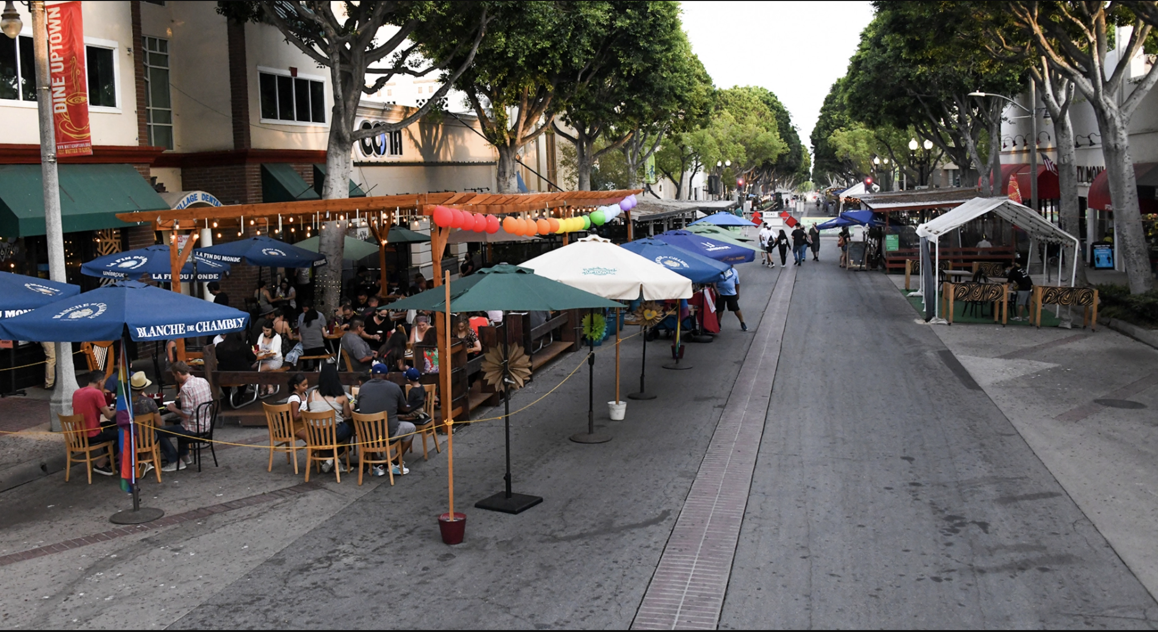
3RD STREET PROMENADE — CAR-FREE SINCE 1965!
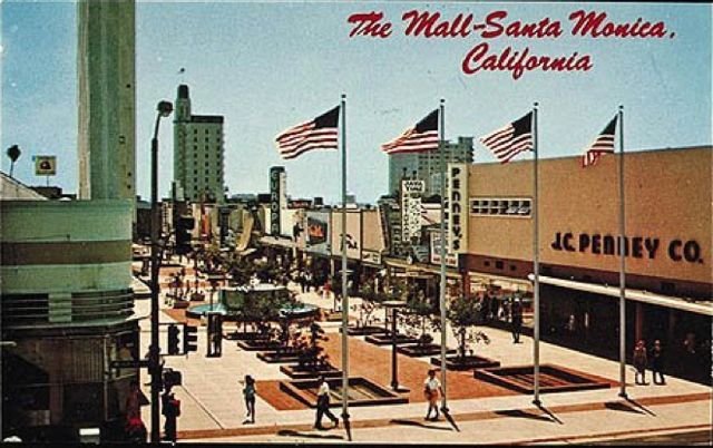
Downtown Santa Monica‘s 3rd Street Promenade opened as the Santa Monica Mall on 8 November 1965. It had been a busy commercial corridor since the late 1800s. The Santa Monica Mall was redesigned in 1989. Dinosaur topiary fountains were designed by Les Lalanne. Murals were painted by Anne Marie Karlsen, Art Mortimer, Ball-Nogues Studio, Cliff Garten, Gilbert “Magu” Luján, and Peter Shire. The mall re-opened as the 3rd Street Promenade on 16 September 1989. I remember fondly the days of the International Food Court, Penny Lane, and Chuck’s Bike-O-Rama but there’s no denying its economic success. All of those are long gone, though, and frankly, it’s far too bourgie for my tastes — but that doesn’t mean that it’s not a success. Today, the 3rd Street Promenade is one of the primary economic engines for the city, generating 15% of its total sales tax revenue.
The 3rd Street Promenade is served by Big Blue Bus‘s 5 and 8; and Metro’s 534 lines. It’s also pretty close to Downtown Santa Monica Station.
JAPANESE VILLAGE PLAZA — CAR-FREE SINCE 1978!

From the 1950s through the 1970s, Little Tokyo endured seismic redevelopment. Streets like Requena Street and Jackson Alley were swallowed by parking lots. Woodsworth Court and Moline Alley were absorbed into the car-free Japanese Village Plaza, which opened on 24 October 1978. Unlike nearby Weller Court, which was developed around the same time and which looks rather like a Japanese mall from the late 1970s, Japanese Village Plaza is a themed space, like Chinatown, and one designed to meet 1970s America’s expectations of what a Japanese village should look like. The yagura fire tower and blue-tiled buildings were designed by Asian Angeleno architect David Hyun. On the other side of the small, two-story Little Tokyo Mall, is a less charming pedestrian street, Gilver W. Lindsay Mall, which though it sees comparatively little foot traffic, is home to a piece of public art, Pat Paul Williams‘s 1994 sculpture, Gilbert W. Lindsay Memorial. On the northern end is the mostly car-free stub of Central Avenue (formerly Vine Street). Whatever one might think of the Japanese Village simulacra, its pedestrian orientation has clearly helped it thrive far more than the long-struggling, fortress-like Little Tokyo Galleria‘s car orientation has.
Japanese Village Plaza is served by LADOT’s A; Metro’s L, 30, and 106; and Montebello Bus Line’s 40 lines.
ASTRONAUT ELLISON S. ONIZUKA STREET — CAR-FREE SINCE 1978!
Weller Street was originally developed as part of a stagecoach route from San Pedro to Downtown Los Angeles. Kajima Associates‘ Weller Court opened in Little Tokyo in 1980. At some point — I don’t know exactly when — barriers were placed at 1st Street and 2nd Street, preventing vehicular access. It may’ve been when ground broke on the Weller Court project in 1978. It was almost certainly closed to cars within a few years of that. On 5 August 1981, Asian Angeleno artist Shinkichi Tajiri‘s 1972 sculpture, Friendship Knot, was dedicated there to Kajima’s founder, Morinorsuke Kajima. In 1987, that block of Weller Street was renamed Astronaut Ellison S. Onizuka Street, in honor of Hawaii-born Ellison Shoji Onizuka, one of the astronauts who died in the destruction of the Space Shuttle Challenger. In 1990, Isao Hirai‘s Astronaut Ellison S. Onizuka Memorial was also installed on the short, pleasant pedestrian street.
Astronaut Ellison S. Onizuka Street is served by City of Commerce Transportation‘s 600 Line; LADOT’s A and 534 lines; and Metro’s L, 30, and 106 lines.
WESTMORELAND PROMENADE — CAR-FREE SINCE 1994!
In 1994, Southwestern Law School expanded into a former I. Magnin & Company department store in 1994. The stunning Art Deco building was designed by John and Donald Parkinson and constructed in 1929 for Bullock’s Wilshire. It was presumably when Southwestern expanded into the former department store that a half-block section of Westmoreland Boulevard was permanently closed to automobiles to create the Westmoreland Promenade.
The Westmoreland Promenade is served by Metro’s 20, B, and D lines.
PLAZA DEL VALLE — CAR-FREE SINCE 2004!
Agora Realty & Management Inc. created the outdoor mall, Plaza del Valle, in 1999, after one of the developers was inspired by a visit to San Miguel de Allende. In 2004, it was remodeled and cars were removed. It’s colorful, hosts live music and festivals, and there’s shade provided by trees and shade sails. Most of the businesses cater primarily to Latinos but Bamboo Bistro, with its live music, karaoke, and Filipino food, is popular with Pinoys.
Plaza del Valle is served by LADOT’s Van Nuys/Panorama City; and Metro’s 167, 169, 233, and 761 lines.
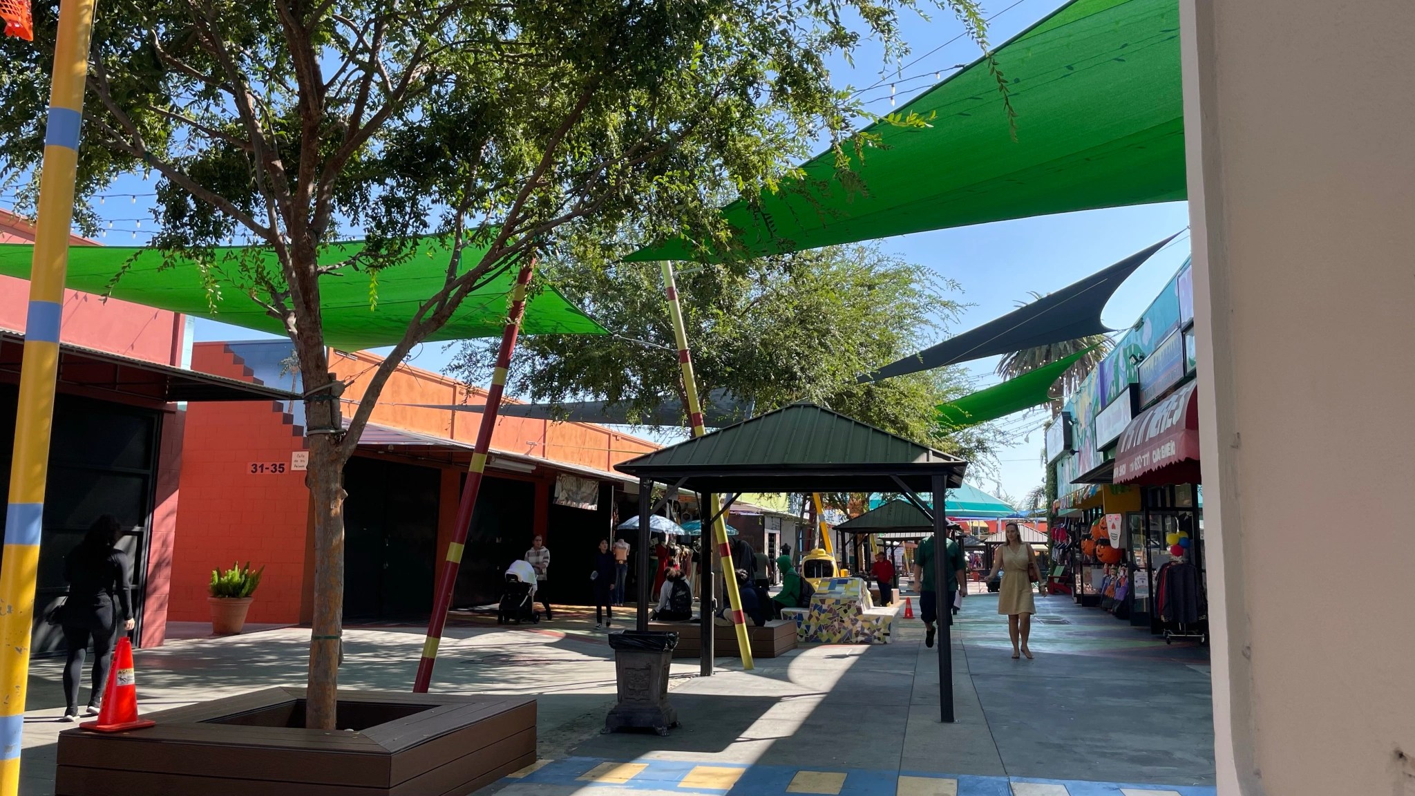
EACA PEDESTRIAN ALLEY — CAR-FREE SINCE 2012!

Downtown Hollywood‘s EaCa Pedestrian Alley opened in early 2012. While alleys in international cities are often charming, mysterious, and vibrant pedestrian corridors, alleys in most American cities are used for little besides dumpster storage, delivery, and public urination. One local exception is Pasadena, the Old Town of which has many great and popular alleys that, as far as I know, were always used primarily by pedestrians. The East Cahuenga Alley was basically a gated dump until the now-defunct Community Redevelopment Agency stepped in in 2008. Before it was gated, it was more commonly known as Heroin Alley. For its renovation, Troy Silva of Urban Nature provided the landscaping. In 2012, it began hosting the Cahuenga Corridor Street Market.
EaCa Pedestrian Alley is served by LADOT’s Hollywood; and Metro’s 212, and 217 lines.
SUNSET TRIANGLE PLAZA — CAR-FREE SINCE 2012!
Silver Lake’s Sunset Triangle Plaza opened for a one-month trial period in March 2012. I remember people weeping and screaming about the loss of eight parking spots. Then came the green-on-green polka dot scheme which seemed to calm down the thin-skinned NIMPS. In a community where the actual center of the neighborhood is a large reservoir that’s been fenced off since the 1940s, the Triangle Plaza — designed by Rios Clementi Hale Studios (RCHS) — quickly emerged as one of the neighborhood’s primary community hubs, hosting the Silver Lake Farmers’ Market, the Silver Lake Picture Show outdoor film screenings, flea markets, and al fresco diners. When the new city councilperson representing CD13 takes office in December, hopefully, he’ll seize on the plaza’s ten-year anniversary to renovate and improve the plaza. I’d love to see it expanded onto Edgecliffe (already closed several times a week), a self-cleaning restroom (so that visitors don’t have to go door-to-door begging businesses), and some more trees or shade structures. I also like Vivian Ku‘s (Pine & Crane) idea — ping pong tables.
The Sunset Triangle Plaza is served by Metro’s 2 and 4 lines. It also includes on it a Metro Bike Share station.
LEIMERT PARK VILLAGE PLAZA — CAR-FREE SINCE 2015!
The Leimert Park Village Plaza was created on a stretch of 43rd Place in the heart of the Leimert Park neighborhood. It was created by the LADOT in partnership with Institute for Maximum Human Potential (IMHP). It re-opened to everyone except cars in February 2015.
Leimert Park Village Plaza is served byLADOT’s Leimert/Slauson Line; and Metro’s 40, 105, 210, and K lines.
BRADLEY PLAZA GREEN ALLEY — CAR-FREE SINCE 2015!
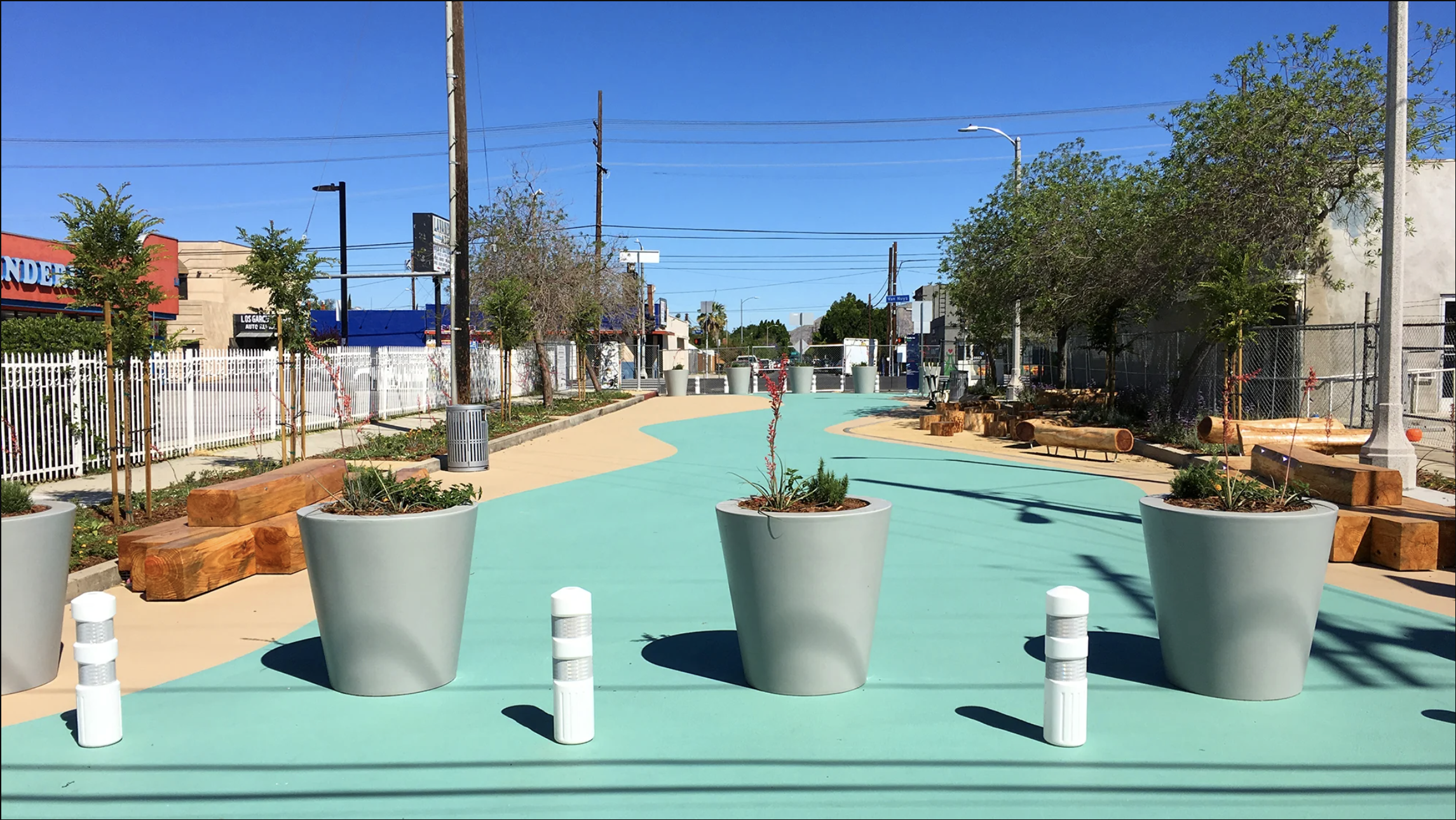
In 2015, an alley in Pacoima between Bradley Avenue and Van Nuys Boulevard was re-claimed from cars by the LADOT, in order that it could be imagined as a community asset. Bradley Plaza Green Alley was the first project from Pacoima Beautiful’s Urban Greening Plan. The design was created by Arup with RCHS and with input from the indigenous Tataviam, whose village of Pacoingna was historically located there. Now stormwater is filtered by plants before recharging the aquifer.
Bradley Plaza Green Alley is served by Metro’s 233 Line.
NOHO PLAZA — CAR-FREE SINCE 2015!
NoHo Plaza, in the NoHo Arts District, converted an alley into a pedestrian plaza in February 2015. LADOT partnered with the North Hollywood Business Improvement District through the People St program. The BID thus manages and maintains the plaza. It’s served by Metro’s 155, 224, and 501 lines. It’s also about two blocks from North Hollywood Station, which is served by the B and G lines as well as many others.
DOCK STREET — CAR-FREE SINCE 2017!
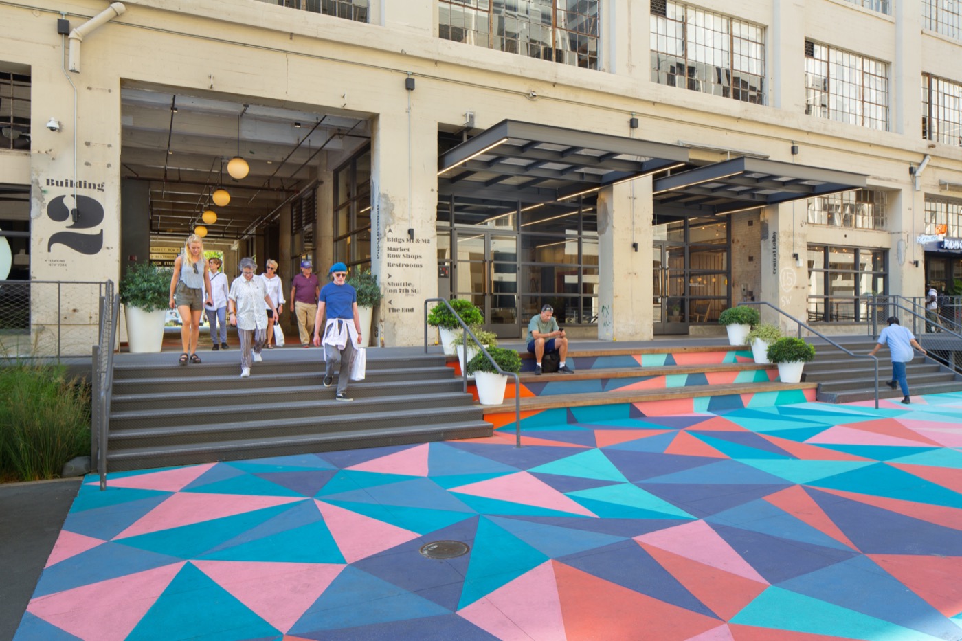
Next to the 7th Street Produce Market, established in 1917, and the John Parkinson-designed Los Angeles Terminal Market, built between 1917 and 1923 as the terminus of the Southern Pacific Railroad line. In 2000, Canadian apparel brand, American Apparel, moved into the building, remaining there until 2017, when it became Row DTLA. On Sundays, the marketplace hosts Smorgasburg, a food market that originated in Williamsburg. I’m not sure exactly when cars were removed from Dock Street. There were still cars using “The Narrows” between buildings 3 and 4 in 2016 and Dock Street was being redesigned by RCHS. It was probably right after Row DTLA moved in. Technically Dock Street is still open to delivery vehicles that arrive and depart early in the morning but by day the loading docks are Row DTLA’s dining terrace.
Dock Street is served by Metro’s 18, 53, 60, and 62 lines. It’s also pretty close to Greyhound‘s Los Angeles Station.
GREENLEAF PROMENADE — CAR-FREE SINCE 2020! (UPDATE: CARS WERE BACK AS OF 2024)
Efforts to reclaim a section of Uptown Whittier‘s Greenleaf Avenue for people had been in the works for years. Then, during the COVID-19 pandemic, Whittier‘s City Council finally voted to try it out in 2020. It was a success — not just helping some businesses weather the pandemic but by creating an attraction that will hopefully outlast it. Whittier’s City Council voted unanimously to keep Greenleaf Promenade in 2021. When I visited Whittier earlier this year, it was easily one of the most appealing parts of my exploration. Sadly, as of 2024, the promenade had been turned back to cars and, predictably, the street felt both hostile and lifeless. Perhaps common since and capitalist urges will prevail — and the city will see the error of its ways and restore it.
The Greenleaf Promenade is served by Montebello Bus Lines‘ 10 and 50; Norwalk Transit‘s 7 lines.
BROXTON PLAZA — CAR-FREE SINCE 2024!
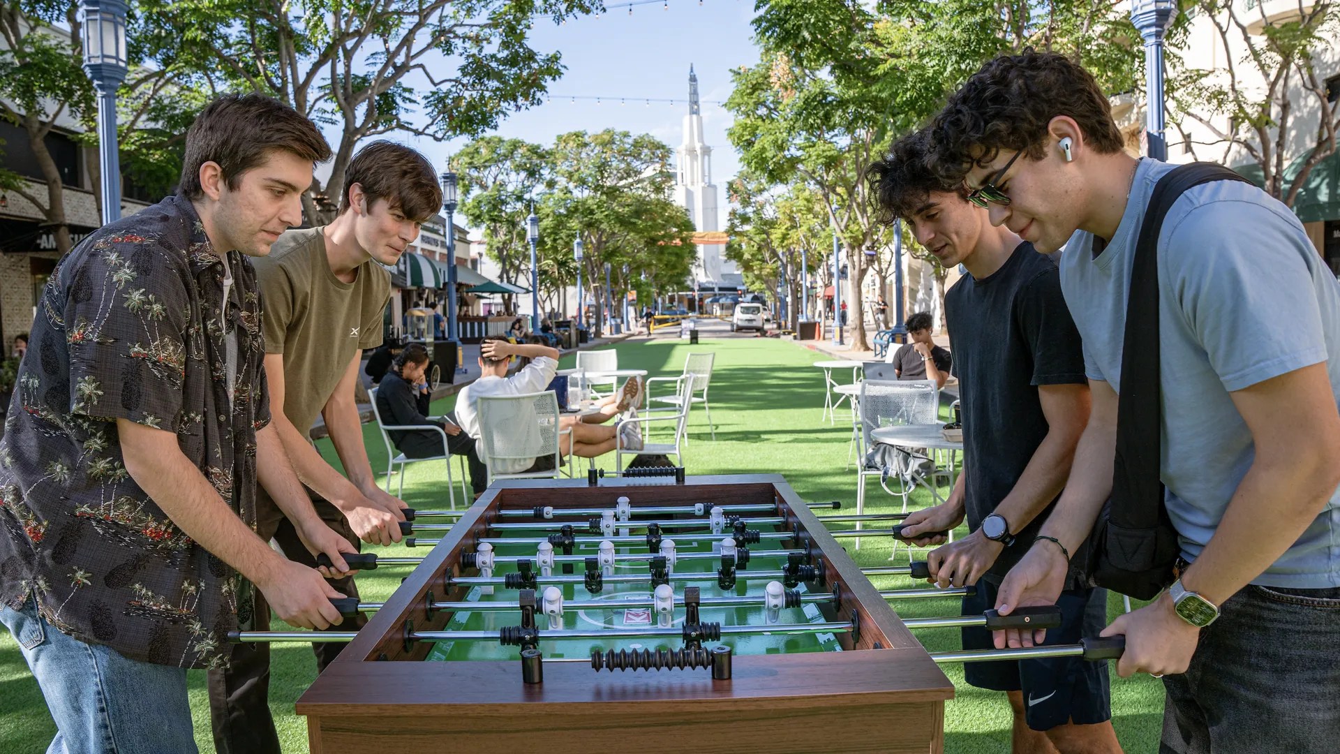
Broxton Plaza had its soft opening in Westwood Village on 25 October 2024 after construction began that August. The Westwood Village Improvement Association (WVIA) secured approval for the project, with the support of the North Westwood Neighborhood Council, in 2023. Since it’s soft opening, it’s hosted al fresco diners, crafters, games, a weekly farmers market, a weekly flea market, film screenings, live music, yoga, It had its official, grand opening on 22 February 2025.
Broxton Plaza is served by Big Blue Bus’s 1, 2, 8 17, and 18 lines; Culver City Bus‘s 6 Line, LADOT’s 573 Line, Metro’s 233, 602, and 761 lines; and Santa Clarita Transit’s 792 and 797 lines.
THE FUTURE IS CAR-FREE
I defy anyone to find a street that’s been re-claimed for people that isn’t better now than it was before. I’m not so unrealistic to imagine that private automobiles won’t be a fact of life for probably as long as I live but there’s no time like the present to start de-escalating. Vehicle miles traveled continue to drop whilst mass transit ridership increases. Of the 88 Los Angeles County cites, the City of Los Angeles is ranked 27th for per capita car ownership. Los Angeles is, in other words, no longer even the car capital of Los Angeles — much less, the world.
Someday, maybe, we’ll relegate single-occupancy vehicles to a network of streets the way we now do with bikes, pedestrians, and buses. Maybe someday we’ll zero-occupancy vehicles to paid storage spaces or private garages. Dream of and word toward a car-free Westwood Boulevard in Tehrangeles, 6th Street in Koreatown, Sawtelle Bouelvard in Little Osaka, Hollywood Boulevard in Thai Town, Vermont Avenue in Los Feliz Village, 3rd Street in Little Bangladesh, Fairfax Avenue in Fairfax Village and Little Ethiopia, Alvarado Street in Westlake, Pioneer Boulevard in Little India, Santa Monica Bouelvard in West Hollywood, Abbot Kinney Boulevard in Venice, Museum Row in the Miracle Mile. Advocate for expanding Car-Free Weekends on Main Street to weekdays. Someday, maybe, we can make dense, walkable, transit-served regions like Downtown and Hollywood — plus neighborhoods like Koreatown and Westlake — entirely car-free.
*except for lowriders
Support Eric Brightwell on Patreon

Eric Brightwell is an adventurer, essayist, rambler, explorer, cartographer, and guerrilla gardener who is always seeking paid writing, speaking, traveling, and art opportunities. He is not interested in generating advertorials, cranking out clickbait, or laboring away in a listicle mill “for exposure.”
Brightwell has written for Angels Walk LA, Amoeblog, Boom: A Journal of California, diaCRITICS, Hidden Los Angeles, and KCET Departures. His art has been featured by the American Institute of Architects, the Architecture & Design Museum, the Craft Contemporary, Form Follows Function, Los Angeles County Store, the book Sidewalking, Skid Row Housing Trust, and 1650 Gallery.
Brightwell has been featured as subject in The Los Angeles Times, VICE, Huffington Post, Los Angeles Magazine, LAist, CurbedLA, Eastsider LA, Boing Boing, Los Angeles, I’m Yours, and on Notebook on Cities and Culture.
Brightwell has been a guest speaker on KCRW‘s Which Way, LA?, at Emerson College, and the University of Southern California.
Brightwell is currently writing a book about Los Angeles and you can follow him on Ameba, Duolingo, Facebook, Goodreads, Instagram, Mubi, the StoryGraph, and Twitter.


3 thoughts on “Nobody Drives in LA — Re-Claiming Los Angeles’s Streets from Cars with Pedestrian Plazas”