

INTRODUCTION
2019 is the sestercentennial of San Diego‘s founding. It’s also the vigintennial of my moving to Southern California — and yet, in those twenty years, I’ve probably visited San Diego no more than a dozen times.
Why haven’t I visited California‘s second-largest city more often? Certainly not out of any of the sort of regional one experiences so often in the San Francisco Bay Area. Nor have I avoided the city entirely out of disinterest — although I’ve long suspected (rightly or wrongly) that most of the things that be of interest to me are readily available closer to home. I regard it somewhat as I do Birmingham — the UK‘s second-most populous city. Like San Diego, it’s far enough from the region’s most populous city to have its own gravitational pull — and yet don’t all the culture-makers from there inevitably relocate to London? …and don’t all the culture-makers from San Diego end up somewhere else?
San Diego is, perhaps, both too close and too far from Los Angeles… in part due to the pitiable state of the US’s transit infrastructure. Although less than 200 kilometers away, it takes longer to journey there via the slow-but-scenic Pacific Surfliner than it does to get from Seoul to Busan, Taipei to Kaohsiung, or London to Manchester. Mind you, if the US had transit equal to that found in Asia and Europe, the same journey might take as few as 45 minutes — and if that were the case, I’d undoubtedly be there much more often.
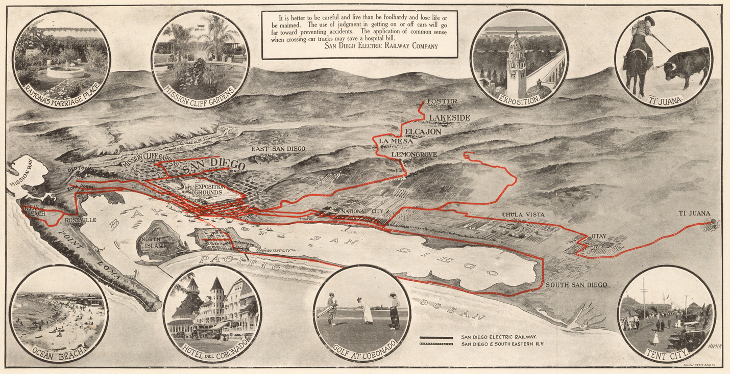
Car-free is the only way to experience cities, though, and whenever I’ve gone to San Diego it’s struck me as prohibitively un-walkable. In 1886, San Diego was served by a system of horse and mule-drawn streetcars. In 1887, electric streetcar service began. However, in 1949, the service of the San Diego Electric Railway Company ended, making San Diego the first major American city to dismantle its passenger rail service. Today there is the San Diego Metropolitan Transit System as well as the North County Transit District but those two agencies (and a handful of others in smaller communities) are charged with providing transit for a county of 11,720 km2 and a population of nearly 3.5 million people. A single commuter rail line, a single light rail line, three trolley lines, three bus rapid transit lines, and a few dozen local buses hardly seem sufficient for a 21st-century metropolis in the world’s wealthiest nation.
That said, in working on this San Diego neighborhood primer, its come to my attention that there are apparently a good many walkable neighborhoods in California and my view of the city has undoubtedly been colored by the fact that coming to San Diego from Los Angeles means passing through the vast red-tile sea which typifies the city’s northern sprawl of master-planned communities but not the city’s entirety. My experience of San Diego thus far, in other words, may’ve been one typified by office parks, surface parking lots, and the empty sidewalks which pass along both in the shadow of freeways — but I’ve never been to Point Loma or Old Town. What’s more, a few areas that I have explored (e.g. University Heights, North Park, and Little Italy) should’ve clued me into the fact that there are pleasant places to ramble even in an automobile-dependent city.
So, I’ve finally compiled a guide to San Diego’s neighborhoods with the hope that readers will vote for as many as they’d like to see covered in future editions of California Fool’s Gold. Mention in the comments or otherwise contact me to let me know which neighborhoods you’d like me to explore and I’ll tally the votes. At the time of writing, Kensington has the most votes, followed by City Heights and University Heights.
A BRIEF HISTORY OF SAN DIEGO
San Diego (Spanish for “Saint Didacus“) is the eighth most populous city in the US — coming in behind San Antonio and ahead of Dallas. It’s known for its mild chaparral climate, natural harbor, beaches, long association with the US Navy, and animal parks.
The San Diego area was historically the homeland of the Kumeyaay people, whose ancestors likely lived in the region for several millennia before 7,000 BCE, around which time two distinct Kumeyaay cultures arose — the Ipai in the north and the Tipai in the south. Thousands of years of relative stability came to an end in 1542 CE, when Juan Rodríguez Cabrillo landed in San Diego Bay and claimed the Kumeyaay homeland for the Spanish Empire — although another 227 more years passed before the Spanish Conquest really got underway with the 1769 establishment of the Presidio Reál de San Diego and Mission San Diego de Alcalá.
Although San Diego was Spain’s foothold into Alta California, the settlement remained small throughout their reign. Mexico declared independence from Spain in 1810 and eleven bloody years of conflict followed before Spain accepted defeat. San Diego remained a small settlement but in 1834 was granted by the Mexican government the status of “pueblo.” After a population decline, however, that status was revoked in 1838.
The US invaded Mexico in 1846 and in 1848, the defeated country ceded 1,370,100 km2 of land to the victorious US, including all of California, which was admitted as a state in 1850. American San Diego remained a small town until the 1878 arrival of the railroad effectively ended its isolation. In the 1970s, San Diego’s population grew so much that it overtook San Francisco as the second-most-populous city in California — San Francisco would again be overtaken in the 1980s, by San Jose.
The 1901 establishment of a Navy coaling station in Point Loma marked the beginning of the city’s long association with the American military. In the early 20th century, San Diego was given a boost when it hosted two World Fairs: the Panama-California Exposition (1915–’16) and the California Pacific International Exposition (1935–’36). For many decades, San Diego was also known as the “tuna capital of the world,” but the last of the canneries closed decades ago. Following the conclusion of the Cold War, the economy began to shift away from defense and aerospace industries toward science and tourism.
According to the US Census Bureau, the estimated population of San Diego in 2017 was 1,419,516 people, 43.1% of whom identified as non-Latino white, 16.8% as Asian, 6.4% as black, .4% as Native American, .4% as Pacific Islander, and 5.1% as of two or more races. 30% of San Diegans identified as being Latino (of any race). The vast majority of San Diegan Latinos are of Mexican descent but there’s a small but significant Puerto Rican minority. The Asian population of San Diego is much more diverse, with that population having (in descending order of prevalence) Filipino, Chinese, Vietnamese, Indian, Korean, Japanese, Laotian, Cambodian, or Thai backgrounds. Most Pacific Islanders are Guamanian, Samoan, or Hawaiian.
San Diego’s Metropolitan Area can be divided into several districts which contain within them several neighborhoods. It’s worth noting, however, that there is little general agreement about what areas constitute what regions, and different sources define and name regions differently. Some of the more widely accepted regional designations for the region include the Anza Borrego (aka Desert Region or Inland Region, Central, Centre City (aka Downtown), Cuyamaca, East County, Eastern, Mid-City, Mountain Empire, Navajo, North County, Northeast, Northern, South Bay, Southeast, South, Uptown, and Western.
MAPPING SAN DIEGO
Although I’ve written primers for all ten counties in Southern California as well as all of Los Angeles’s neighborhoods, I put off making one for San Diego for several reasons. One, I knew it would be time-consuming (which it was). Two, I don’t really know San Diego well and I don’t know of any great resources. In 2009, the Los Angeles Times launched Mapping L.A., an attempt to comprehensively define the boundaries of Los Angeles’s neighborhoods. Although not without both its controversies as well as its considerable blind spots, it was an extremely helpful resource in making my own map of Los Angeles County communities. As far as I know, however, neither the San Diego Union-Tribune nor any other party has thus far undertaken a similar project for San Diego… until now.
To make this map and primer, I relied on several resources, including, primarily, Wikipedia, Google Maps, and the government of the City of San Diego. The latter divides the city into 53 planning areas. Google has, at best, a spotty track record when it comes to neighborhood geography — and their recent decision to add multi-national fast food chains as map features is surely the latest violation of their motto, “Don’t be evil,” and yet they’re still more trustworthy than NextDoor — which seems to exist primarily to stoke unneighborly fear and hatred. That site balkanized San Diego into 282 neighborhoods — most of which have no basis in either usage or history. Wikipedia, great but flawed, lists 126 neighborhoods. I also went with my gut and the resulting map is, I’m sure, imperfect. If you disagree with boundaries, names, or anything else, please politely make your case in the comments and I’ll do my best to incorporate your view — although bear in mind that a neighborhood map that satisfies everyone is an impossibility.
And now, the neighborhoods…
ALLIED GARDENS
Allied Gardens is a residential neighborhood developed by Louis L. Kelton and Walter Bollenbacher in 1955, who in that year purchased 1,000 acres of the Waring Estate. Their company was called Allied Contractors. A small business district along Waring Road between Orcutt and Zion hosts a few businesses, service firms, and restaurants. The neighborhood is also home to the Allied Gardens Recreation Center and Allied Gardens Pool and several parks. On Sundays, it hosts a farmers market.
ALTA VISTA
Alta Vista is a small neighborhood in Southeast San Diego. Its name was shared by the once-dominant internet search engine.
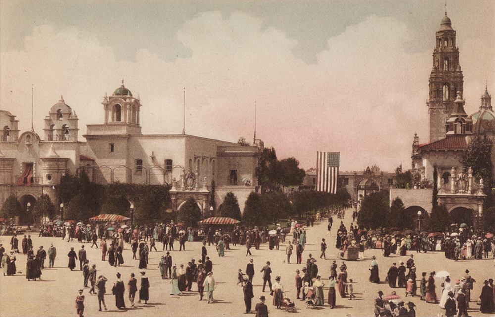
BALBOA PARK
Balboa Park is a 490-hectare “urban cultural park” and, broadly speaking, a neighborhood. In addition to open space areas, natural vegetation zones, green belts, gardens, and walking paths, it is also home to museums, recreational facilities, theaters, and the San Diego Zoo. It was created in 1835 when it was set aside for public recreational use. It was dedicated as a park in 1868.
BANKERS HILL (or PARK WEST)
Bankers Hill, also known as Park West, is a neighborhood in San Diego’s Uptown. The southern end of the neighborhood is primarily residential and many single-family homes there date from the late 19th century. It acquired its name from its reputation for affluence.
BARRIO LOGAN
Barrio Logan is a coastal neighborhood named after Congressman John A. Logan, who in 1871 wrote legislation to provide federal land grants and subsidies to a transcontinental railroad that never materialized. In 1881, a new street was named Logan Heights, which over time came to lend itself to the neighborhood. In 1910, Mexican refugees of that country’s revolution began settling in the neighborhood and it came to be known more commonly by its current name. During World War II, Naval Base San Diego expanded into the until-then mostly residential barrio. Rezoning for industry accelerated in the 1950s and ’60s. The construction of Interstate 5 in 1963 and the San Diego-Coronado Bridge in 1969 further scarred the community. Today over half the neighborhood’s Community Plan Area is under the jurisdiction of either the United States Navy or the Port of San Diego. In the 1970s, it was the site of a non-violent uprising against more redevelopment, and Chicano Park was dedicated on a site previously intended for a federal building. The concrete pillars of the bridge and freeway are well known for their murals.
BAY HO
Bay Ho is a neighborhood within the Clairemont community of San Diego.
BAY PARK
Bay Park began as the Bay Park Village Subdivision, the creation of which was approved by San Diego City Council in 1936. Bay Park Elementary School was built there in 1939.
BAY TERRACES
Bay Terraces is a hilly neighborhood that was annexed by San Diego in 1969. It has a large Filipino population and is home to Itliong-Vera Cruz Memorial Bridge — named after Larry Itliong and Philip Vera Cruz.
BIRDLAND
Birdland is so known for its streets, which are named after different avian species. Most of the neighborhood was developed in the late 1950s and early 1960s when it was referred to in planning documents as “El Dorado.” Although primarily comprised of single-family homes, Birdland is also home to several medical facilities.
BLACK MOUNTAIN RANCH
Black Mountain Ranch is a community developed in northeastern San Diego by businessman Fred Mass. It primarily consists of two housing developments — Del Sur and Santaluz. It is home to Black Mountain Ranch Open Space Park.
BORDER
Border is a matter-of-factly named neighborhood, the primary significance of which is owed to the presence there of the San Ysidro Port of Entry — one of the busiest land border crossings in the world. It is often regarded as part of the larger San Ysidro neighborhood.
BROADWAY HEIGHTS
Broadway Heights is a community that was approved for development in the 1950s. Most of the single-family homes which dominate the small neighborhood were built around 1960. Broadway Heights has for many years been the heart of San Diego’s black community. In 2010, Weston Street — which passes near the community — was renamed Martin Luther King Jr. Way following a campaign led by the Broadway Heights Community Youth Council.
BURLINGAME
Burlingame is an historic district located within the Greater North Park Community Planning Area. It is recognized for its residential architecture, which represents styles including Art Deco, California Ranch, Craftsman, Mission Revival, Prairie School, Spanish Colonial Revival, and Tudor Revival.
CARAMEL MOUNTAIN RANCH
Carmel Mountain Ranch is sometimes shortened to simply Carmel Mountain or CMR (not to be confused with Cash Money Records). It is home to several shopping centers and a country club, most of which incorporate “Carmel Mountain” into their name. It is also home to the Carmel Mountain Ranch Community Park. It’s worth noting, however, that the community and its shopping centers are located near the base of Black Mountain whereas Carmel Mountain is located about sixteen kilometers to the east.
CARMEL VALLEY
Carmel Valley is a mostly-white master-planned community in Northwest San Diego. It is home to residences, hotels, business parks, and businesses. The master plan was created in 1975 and it was originally known as North City West. Construction didn’t begin until 1983. In the early 1990s, it was renamed Carmel Valley.
CHOLLAS CREEK
The Chollas Creek neighborhood is generally considered to be a subdivision of the City Heights neighborhood. Its name is derived from the waterway of the same name, which in turn derives its name from the arborescent cacti that thrive there.
CHOLLAS VIEW
The Chollas View neighborhood is named after the large numbers of cholla that formerly characterized the area. Although Holy Cross Cemetery was established there in 1919, most living humans began to arrive during and after World War II. Although mostly Latino, the neighborhood is also home to a large Laotian minority, who as of 2010 comprised 12% of the populace.
CITY HEIGHTS
City Heights is home to large numbers of both residences and businesses and is thus one of San Diego’s most walkable communities. Development began in the 1880s when Abraham Klauber and Samuel Steiner purchased land referred to as the “Steiner, Klauber, Choate and Castle Addition.” It was incorporated as the city of East San Diego on 2 November 1912. On 31 December 1923, it was annexed by San Diego and came to be known as City Heights.
CIVITA
Civita is a sustainability-minded master-planned community located atop a former quarry. The quarry opened in 1937 and was operated by the Grant Family, who along with local developer Sudberry Properties, are the parties responsible for the development. Alta and Franklin Grant originally purchased land hoping to find oil but, finding none, opened a quarry and the community was originally named Quarry Falls. Ground broke on the development in 2010. The civic master plan was designed by local architect and planner Gordon Carrier, of Carrier Johnson + Culture.
CLAIREMONT
Clairemont (or Clairemont Mesa) is a large community that is sometimes divided into Bay Ho, Clairemont Mesa East, Clairemont Mesa West, and North Clairemont. It’s named after Claire Tavares, wife of Carlos Tavares — who developed the community along with Louis Burgener — the other half of the Burgener and Tavares Construction Company. The two purchased the land in 1950 to develop what was then the city’s largest post-war subdivision. Residents began moving in in 1951.
COLINA DEL SOL
The Colina del Sol neighborhood is dominated by Colina del Sol Park. It’s home to numerous Vietnamese restaurants, markets, and other businesses.
COLLEGE AREA
The College Area is named after its dominant feature, San Diego State University — which was formerly known as San Diego State College. Most of the area was developed in the 1930s and ’40s. The university was founded in 1897 as the San Diego Normal School, making it the third-oldest university in the California State University system.
COLUMBIA
Columbia is a largely commercial neighborhood — although in the last decade, it’s seen the development of several large condominiums. It’s also home to two museums: the Midway Aircraft Carrier Museum and the Maritime Museum of San Diego.
CORE
The Core district is the name of San Diego’s central business district.
CORTEZ HILL
Cortez Hill‘s name is derived from the historic El Cortez Hotel (now known as El Cortez Condominium). It is one of San Diego’s oldest residential neighborhoods and is known for its Victorian-era homes.
DEL CERRO
Del Cerro is an affluent neighborhood located within the Navajo community planning area. It was mainly developed in the 1950s, ’60s, and ’70s. It is home to Del Cerro Park and Pool — although they are off-limits to the public.
DEL MAR HEIGHTS
Del Mar Heights is a hilly, affluent neighborhood located in the shadow of the 5 Freeway.
DEL MAR MESA
Del Mar Mesa is a semi-rural residential community developed in the 2000s. More than a third of the area is preserved as open space and is traversed by trails.
EAST ELLIOTT
East Elliott is a depopulated community. It was formerly part of Camp Elliott, a training facility of the US Marine Corps that was established in 1941. Roughly half the camp was sold in 1961 and turned into Mission Trails Regional Park and the communities of Tierrasanta and East Elliot. In 1997, the majority of East Elliot was designated open space. Homes were built along the eastern edge in 2003 but in 2013, that community was de-annexed by San Diego and annexed by the neighboring city of Santee. When the neighborhood’s Sycamore Canyon Landfill closes, it will be revegetated with native plants.
EAST VILLAGE
East Village is a large neighborhood in San Diego’s Centre City. Dominated by warehouses, by the late 20th century it was home to artists and dive bars. Today it’s characterized by luxury lofts, condominiums, upscale restaurants, hotels, and art galleries. The Rob Quigley-designed Central Library was completed there in 2013. It’s also home to Petco Park, the Thomas Jefferson School of Law, the New School of Architecture and Design, the Fashion Institute of Design and Merchandising, and San Diego City College.
EGGER HIGHLANDS
Egger Highlands is a residential neighborhood in South San Diego. It’s named after the Egger family, who donated the land to St. Charles Catholic Church in 1946. It’s also home to Robert Egger, Sr. Community Park. It was annexed by San Diego, along with the rest of South San Diego, in 1957.
El CERRITO
El Cerrito is a mostly residential suburb with businesses limited to its border streets. The “cerrito” of the neighborhood’s name refers to a low protrusion which rises between 55th and 58th streets and encircled by Overlook Drive. Formerly dominated by lemon and orange groves, it was developed with homes in the 1920s, following the creation of El Cajon Boulevard.
EMERALD HILLS
Emerald Hills is a neighborhood built on a Kumeyaay burial site. It is named after the Emerald Hills Country Club and Golf Course, which was established in 1929. What remained of the golf course was sold to developers in 1958. It’s home to the Malcolm X Library and Performing Arts Center.
ENCANTO
Encanto is a hilly, low-density neighborhood sometimes subdivided into North Encanto and South Encanto — with Broadway serving as the border between the two. Businesses and industries are limited, for the most part, to major streets.
ESCALA
Escala is a small residential community in the Mission Valley area. Adjacent is the Escala Dog Park. It’s served by the Escala Home Owners’ Association.
FLEETRIDGE
Fleetridge is a hilly residential neighborhood on Point La Loma named after developer David Fleet. It was developed between 1950 and 1955. The neighborhood is home to Point Loma Park. It is often lumped together with the much older, neighboring community of Roseville as “Roseville-Fleetridge.”
FOX CANYON
Fox Canyon is generally regarded as part of the City Heights neighborhood. It is home to the historic Egyptian Garage and Euclid Tower. It is served by the Fox Canyon Neighborhood Association.
GASLAMP QUARTER
The Gaslamp Quarter (or the Gaslamp District) is a neighborhood in Centre City. Its designation owes to a fetishization of retro aesthetics and historical revision at somewhat ironic odds with its original name, New Town. Development of the area began in 1867 when Alonzo Horton purchased land there hoping to create a modern rival to San Diego’s Old Town. Even back then, street lighting was provided by electric lightbulbs. From the 1880s-1900s, it was nicknamed the Stingaree and was known for its bordellos, gambling halls, and saloons. From the 1950s-1970s, it was known for its bookstores, “massage” parlors, and porno theaters. In 1976, efforts were launched to class up the district and preserve its aging architecture. The area was renamed the Gaslamp Quarter and new gas lamps were installed to heighten it’d old-timey vibes, however historically inappropriate.
GATEWAY
Gateway is a small Mid-City neighborhood hemmed in by interstate freeways. Its name, presumably, is derived from Gateway Drive. It’s mostly residential, although there is are a few businesses along Home Avenue.
GOLDEN HILL
Golden Hill is an historic, walkable, and architecturally eclectic neighborhood that includes numerous homes from the late 19th and early 20th century. It has a reputation as a bohemian enclave. In the 1970s, it was home to the first Gay Center. It was also the original home of the Women’s History Museum and Educational Center. It is today home to several recording studios and cafés favored by artists and musicians. The free Golden Hill Block Party occurs every October and features live music.
GRANT HILL
Grant Hill is a small neighborhood centered around Grant Hill Neighborhood Park.
GRANTVILLE
Grantville is one of the oldest communities in San Diego. In 1774, the Mission San Diego de Alcalá was moved to what’s now Grantville. In the late 19th century, it was named Grantville in honor of President Ulysses S. Grant. It was annexed, in pieces, by San Diego between 1948 and 1954.
HARBOR ISLAND
Harbor Island is, despite its name, a peninsula created in 1961 from debris dredged out of San Diego Bay. It’s home to several marinas, restaurants, and high-rise hotels. It is under the jurisdiction of the Port of San Diego.
HARBORVIEW
Harborview is a small district on the San Diego Bay. It’s home to Waterfront Park as well as several museums, including the HMS Surprise, the Maritime Museum of San Diego, the Star of India, and the USS Dolphin.
HILLCREST
Hillcrest is a walkable Uptown suburb known for its cafés, bars, clubs, thrift stores, and independent shops. Many of the residences are in either the craftsman or mid-century modern styles. Development of the community occurred mostly between 1910 and 1920. The lighted “HILLCREST” sign was installed in 1940, having been donated by the Hillcrest Women’s Association. It was restored and replaced in 1984. Hillcrest is also widely regarded as San Diego’s main gayborhood. In the 1970s, much of San Diego’s gay community came to the neighborhood and in 1975, the first city-permitted gay pride parade took place there. In 2012, Blaine Avenue was renamed Harvey Milk Street.
HORTON
Horton is a Centre City neighborhood that is home to the five-story Horton Plaza (scheduled to be redeveloped into the Campus at Horton) and Horton Plaza Park. All are named after prominent Connecticut-born real estate developer Alonzo Horton.
ISLENAIR
Islenair is a residential, city-designated historic district. Most of the homes there were built between 1926 and 1952. It was developed by real estate investors James Love and William Touhey. The name was meant to poetically suggest “Island in the Air.”
JAMACHA
Jamacha is a largely residential neighborhood named for the Jamacha Valley and Rancho Jamacha, the latter a Mexican land grant estate. In the past, the name was variously spelled Xamacha, Jamacha’, ‘Jamacho, and Gamacha. All are likely derived from the Kumeyaay work, “xamca,” meaning “wild gourd.”
KEARNY MESA
Kearny Mesa is named after Camp Kearny, a former military base that operated there from 1917 to 1946. The base was named after Brigadier General Stephen W. Kearny, a veteran of the Mexican-American War. Since the mid-1950s, it has been a center of aerospace, electronic, and other industrial concerns. It’s today also known for its pan-Asian minority — mostly Chinese, Korean, Japanese, Thai, and Vietnamese.
KENSINGTON
Kensington was founded as Kensington Park in 1910. The land on which it is located was owned by Abby (née Hall) Hitchcock and Mary (née Hall) Gleason — two sisters who inherited the lands of Rancho Mission from the estate of their deceased brother and mother. It was a streetcar suburb, located along an extension of San Diego Electric Railway’s Adams Avenue Line. The original homes were all in the Craftsman style but in the 1920s, many were built in the Spanish Colonial Revival style. Later developments included Kensington Manor and Kensington Heights. The communities, collectively known as Kensington, were annexed by San Diego in 1952. A neon sign stating “KENSINGTON” was installed in 1953.
LA JOLLA
La Jolla is a hilly, coastal neighborhood known for being the home of the University of California, San Diego, founded there in 1960. The Kumeyaay referred to the region as “mat kulaaxuuy,” meaning “land of holes” — a reference to the abundant sea caves. Development of the area was begun in earnest by speculators Frank T. Botsford and George W. Heald in the 1880s. In the 1890s, the San Diego, Pacific Beach, and La Jolla Railway connected La Jolla to San Diego and it became famed as a resort area. Philanthropist Ellen Browning Scripps moved to La Jolla in 1896 and commissioned many of the community’s notable buildings. From 1917-1964 it was home to the US Marine Corps’ Camp Calvin B. Matthews. It is sometimes further subdivided into the neighborhoods of Beach-Barber Tract, Bird Rock, Hidden Valley, La Jolla Alta, La Jolla Country Club, La Jolla Farms, La Jolla Heights, La Jolla Mesa, La Jolla Shores, La Jolla Village, Lower Hermosa, Muirlands, Muirlands West, Soledad South, Upper Hermosa, and Village of La Jolla.
LA JOLLA VILLAGE
La Jolla Village (not to be confused with Village of La Jolla) is a mixed residential-commercial neighborhood often considered to be part of the greater La Jolla community. It is dominated by two shopping centers, La Jolla Village Square and the obnoxiously named The Shops at La Jolla Village. It’s also home to Villa La Jolla Park.
LA PLAYA
La Playa is an affluent bayside neighborhood within the larger Point Loma community. It is home to two yacht clubs: San Deigo Yacht Club and Southwestern Yacht Club. La Playa was San Diego’s main port until the establishment of New Town (now Centre City) in the 1870s.
LAKE MURRAY
Lake Murray is a neighborhood centered around a reservoir of the same name. The titular body of water was created with the construction of an earthen dam in 1894.
LINCOLN PARK
Lincoln Park is a neighborhood in Southeast San Diego. It’s traversed by Chollas Creek.
LINDA VISTA
An older community named Linda Vista was destroyed by the 1916 floods of San Diego. This newer Linda Vista was mostly developed in 1940 and ’41 to house aircraft workers. The garden city-inspired Linda Vista Shopping Center, built in 1943, was the oldest in San Diego until it was unceremoniously demolished in 1972.
LITTLE ITALY

Little Italy is a walkable Italian enclave and San Diego’s only named ethnic enclave. In its early years, it was a fishing village. It was later home to much of the city’s canning industry. Though much changed, it remains strongly Italian and is dominated by Italian restaurants and shops.
Click here to read the California Fool’s Gold account of exploring the neighborhood.
LOGAN HEIGHTS
Logan Heights is a neighborhood, like Barrio Logan, named after Congressman John A. Logan. As with neighboring Barrio Logan, it’s predominantly Latino. It is presumably distinguished from its neighbor by its “heights.”
LOMA PORTAL
Loma Portal is a hilly neighborhood overlooking San Diego Bay. Primarily residential, there is nonetheless a small business district along Voltaire Street.
LOMITA
Lomita is a primarily residential community that was mostly developed in the 1950s. At the time, it was mainly home to military families.
MARINA
The Marina district is a bayside neighborhood. Formerly dominated by warehouses, it is now dominated by hotels, residences, and medical offices — as well as Seaport Village and the San Diego Convention Center. San Diego’s oldest park, Pantoja Park, is also located there.
MARSTON HILLS
Marston Hills is named after George Marston, a San Diego businessman, whose residence is now the Marston House Museum.
MEMORIAL
Memorial is one of San Diego’s oldest neighborhoods. It is named after Memorial Park, which is located within the neighborhood.
MIDTOWN
Midtown is a neighborhood sometimes also referred to as Middletown. Mostly residential, there are nevertheless numerous bars and restaurants along India Street.
MIDWAY
Midway (also known as the Midway District or North Bay Area) is a primarily commercial and industrial area with a few multi-family residences. Prior to the confinement of the San Diego River in 1877, Midway was part of the marshy delta. Mission Brewery opened in the area, then nicknamed Dutch Flats, in 1912. The San Diego Municipal Airport/Lindbergh Field opened in 1928 and the area thus came to be dominated by aircraft-related industries. In the 1950s it was known for its automobile-oriented businesses, which included several drive-in restaurants and theaters.
MIRA MESA
Mira Mesa is a neighborhood that was formerly used as a test area and bombing range during World War II. In the 1950s, it began developing as a mostly residential neighborhood for military families. Hourglass Field later became the site of Hourglass Park and San Diego Miramar College. A 1969 housing boom led to an explosion of housing and the neighborhood’s name became a byword for unchecked sprawl so in 1971, mayoral candidate Pete Wilson ran on the promise of “no more Mira Mesas.” Mira Mesa today is perhaps the only San Diego neighborhood with an Asian-Pacific Islander majority — mostly Filipino, Vietnamese, and Hawaiian. It is the site of the annual Mira Mesa Street Fair and is served by both Mira Mesa Living and the Mira Mesa Times.
MIRAMAR
Miramar is a mixed-use community based around Marine Corps Air Station Miramar (formerly Naval Air Station Miramar) — a site made famous in the 1986 film, Top Gun. The name Miramar comes from the name of Edward W Scripps‘s residence, built on Scripps Ranch in the 1890s. It later grew into a small community centered around a railroad station, although none of the buildings from that era survive.
MIRAMAR RANCH NORTH
Miramar Ranch North is an affluent community. Mostly residential, there are numerous fast food chains along its main thoroughfare — Scripps Poway Parkway.
MISSION BAY PARK
Not exactly a neighborhood, in the traditional sense, Mission Bay Park is nonetheless a large and important area of San Diego. Mission Bay is a saltwater lagoon that serves as the basis for the nation’s largest human-made aquatic park. Prior to significant augmentation, the area was a tidal marsh. It was primarily developed from the 1940s through the 1960s, following a 1944 decision by a chamber of commerce committee to transform the tidal wetlands into a center of tourism and recreation. From 1957 to 1962, large amounts of toxic industrial waste were dumped into an unlined landfill next to the bay for which no remediation has occurred. The park is nevertheless popular for all sorts of recreation as well as home to many rare and endangered species.
MISSION BEACH
Mission Beach is a neighborhood situated atop a sandbar that separates Mission Bay from the Pacific Ocean. Boardwalks run along both its bayside and seaside. Many of its residences were built as summer cottages in the 1920s, ’30s, and ’40s. It noteworthily has the smallest lots in the city. Belmont Park, home to the Giant Dipper Roller Coaster and other rides, was built by John D. Spreckels in 1925 to promote his electric railway and to stimulate home sales. A wooden bridge that formerly linked the neighborhood to Ocean Beach was demolished in 1951.
MISSION CITY
Mission City is an area of the larger Mission Valley area. It is a “Class “A” office campus located in the Mission Valley submarket” which is, I assume, a way of saying that there are some office parks there.
MISSION HILLS
Mission Hills is an affluent, primarily residential Uptown neighborhood. The oldest parts of the community were subdivided following George Marston’s 1908 plan. The oldest homes are in a variety of architectural styles including Craftsman, Prairie School, Spanish Colonial Revival, and vernacular. Two historic districts are located within Mission Hills: the Fort Stockton Line Historic District and the Mission Hills Historic District. It was a streetcar suburb until 1939 when service of San Diego Electric Railway’s Fort Stockton Line ended. Newer homes are still relatively old — dating primarily from the 1950 and ’60s.
MISSION TRAILS REGIONAL PARK
Mission Trails Regional Park, whilst not a neighborhood, is a large feature of San Diego which I feel warrants its own entry. The large park consists of canyons, hills, and riparian woodlands as well as both natural and developed recreation areas. 485-meter-tall Cowles Mountain, located within the park, is also the highest point within the city of San Diego. Other sites of interest within the park include a vast system of trails and Old Mission Dam, built for the oldest of California’s Spanish Missions.
MISSION VALLEY
Mission Valley is a neighborhood situated in the wide valley of the San Diego River. It is sometimes subdivided into Mission Valley East and Mission Valley West. In the early 20th century, the area was dominated by dairy farms and quarries. Suburbanization occurred in the 1950s. Westgate Park was built there for the San Diego Padres in 1957 (it was demolished in 1969). The Mission Valley Center opened in 1961 and other malls followed.
MORENA
Morena is a coastal neighborhood bordering Mission Bay. It’s home to the University of San Diego.
MOUNTAIN VIEW
The area which now comprises Mountain View was annexed by San Diego in 1874 (although the adjacent, private Greenwood Memorial Park remains unincorporated). Mountain View Park was dedicated in 1914.
MOUNT HOPE
Mount Hope is a diverse, mixed-use neighborhood named after Mount Hope Cemetery. Next to it and surrounded by San Diego is an unincorporated area encompassing the private Greenwood Memorial Park.
NESTOR
Nestor is a residential neighborhood that was formerly a Japanese farming community. It was annexed by San Diego in 1957. It’s home to the South Bay Drive-In, Berry Park, Nestor Park, and Mount Olivet Cemetery, the latter of which opened in 1899.
NORMAL HEIGHTS
Normal Heights is a walkable neighborhood, the name of which is a reference to the State Normal School (the predecessor to San Diego State University). Development started in 1906, following the 1905 completion of a reservoir nearby and when a syndicate led by D. C. Collier and George M. Hawley filed a subdivision map with the county. The Normal Heights Improvement Association was founded in 1911. A business district arose in the 1920s, along Adams Avenue. It was annexed by Los Angeles in 1925. The community hosts several, free, annual events, including the Adams Avenue Street Fair, Adams Avenue Unplugged, and Art Around Adams.
NORTH CITY
North City is a community designation used mainly by the San Diego Police Department for zoning purposes.
NORTH PARK
North Park is a large but walkable neighborhood that is sometimes subdivided into the smaller neighborhoods of Altadena, Burlingame, the Dryden Historic District, and Morley Field. In 1893, James Monroe Hartley bought 40 acres (16 hectares) of land on which he planted lemon trees. The area came to be known as Hartley’s North Park. Hartley’s son Jack established the real estate firm of Stevens & Hartley which subdivided the land in 1911. It was a streetcar suburb until service ended in 1949. In 1978, two planes collided over North Park, killing 137 passengers and seven people on the ground. It is known for its diversity, restaurants, bars, North Park Music Thing music festival, Ray at Night art walk, and annual North Park Lions Club Holiday Parade.
OAK PARK
Oak Park is a suburban neighborhood centered around a shopping mall, Marketplace at the Grove Shopping Center. It opened with a decidedly less annoying name, College Grove but in the 1990s it was barely hanging on at all. A more attractive neighborhood amenity is Chollas Lake. The rest of the neighborhood is characterized by residences — including Navy housing.
OCEAN BEACH
Ocean Beach is located at the estuary of the San Diego River. It was previously known as Mussel Beach, for the presence of mussels. The Ocean Beach name was first applied in 1887 by Albert E. Higgins and Billy Carlson. The two developers built the Cliff House resort there and subdivided the area. The Ocean Beach Railroad was launched in 1888 but the resort was a failure and Higgins committed suicide. The Cliff House burned down in 1898. Early resident DC Collier then stepped in and did much to develop the area. By 1910 it was flourishing. Ocean Beach Municipal Pier, built in 1966, is the longest concrete pier on the West Coast. By the 1960s, thanks to its organic markets, hippies, and headshops, it was characterized as the “Haight-Ashbury of San Diego.” It’s now home to many antique shops, tattoo parlors, cafés, coffee bars, and feral parrots.
OCEAN VIEW HILLS
Ocean View Hills (also known as Ocean Crest) is a residential neighborhood, the development of which began around 1998. The area in which it is located, however, was annexed in 1957. When still unincorporated, it attracted off-road vehicles and bonfire builders who referred to it simply as “the Pits.”
OLD TOWN
Old Town was the site of the first Spanish settlement in California, home to both the Mission San Diego de Alcalá and the Presidio of San Diego. By the 1820s, Mexican San Diego development was centered around Old Town San Diego State Historic Park. In the 1860s, the center of San Diego’s population moved to what’s now Centre City, then known as “New Town.” In 1871, government records were moved out of Old Town to a new courthouse. The Old Town neighborhood is still home to hotels, restaurants, art galleries, and shops, as well as dozens of historic sites and buildings. It also hosts several annual festivals.
OTAY MESA
Otay Mesa is a community located at the US-Mexican border. Its name comes from the Kumeyaay language, although there is a dispute about which word. Possible candidates include “otai” (brushy), “tou-ti” (big mountain), and “etaay” (big). The first controlled flights in the western hemisphere were undertaken here beginning in 1883 by aviation pioneer John Joseph Montgomery. The Otay Mesa Port of Entry is one of two border crossings in San Diego.
OTAY MESA WEST
Otay Mesa West is a residential neighborhood located along the Otay River.
PACIFIC BEACH
Pacific Beach is a neighborhood known for its nightlife and boardwalk which runs from Law Street to the mouth of Mission Bay. It was developed between 1886 and 1888 by Daniel C Reed, AG Gassen, Charles W Pauley, RA Thomas, and OS Hubbell who sought to attract interest by building a race track, the San Diego College of Letters, and a railway — none of which exist today. Formerly closely associated with surfers, college students, and other young residents; rising housing costs have today transformed the neighborhood into an older, wealthier one.
PACIFIC HIGHLANDS RANCH
Pacific Highlands Ranch is a newly-developed, wealthy residential community, most of which was developed in the 2000s by Pardee Homes. 49% of the community is preserved as natural habitat.
PALM CITY
Palm City is a neighborhood in Southern San Diego. Prior to the American conquest, the area was part of Rancho La Punta, granted to Santiago Emilio Arguello in 1834. The US Land Commission rejected Arguello’s claim which opened up the land for development. In 1913, the community became the terminus of the Mexico & San Diego Railway. Palm City was established in 1914, its name a reference to palm-lined Palm Avenue which itself was rejected as a community name by the US Post Office as unsuitable. It later developed into a Japanese farming community of several hundred.
PARADISE HILLS
Paradise Hills is a neighborhood in Southeast San Diego. It is home to the Paradise Hills Recreation Center.
POINT LOMA
Point Loma is a seaside community located on a hilly peninsula separating the Pacific Ocean from San Diego Bay. It was likely near Ballast Point, in Old La Playa (now part of neighboring Naval Base Point Loma), that Cabrillo first set foot in what’s now California. The name “Ballast Point” is likely derived from the practice of ships discarding their ballast there upon arriving in the bay. The military’s long association with San Diego began as early as 1852 when the southern portion was set aside for the Amry. A Naval coaling station was established there in 1901. Marine Corps Recruit Depot San Diego and the San Diego Naval Training Center followed in the 1920s. It was also the site of Lomaland, the one-time headquarters of the Theosophical Society. It’s now the site of Point Loma Nazarene University. The best-known landmark, however, is the Old Point Loma Lighthouse.
POINT LOMA HEIGHTS
Point Loma Heights is a largely residential neighborhood with both single-family and multi-family homes. Commercial corridors are located along West Point Loma Boulevard and Voltaire Street.
RANCHO BERNARDO
Rancho Bernardo is a sprawling master-planned community located in the northern hills above San Diego which is named after the Mexican Rancho San Bernardo, granted in 1842. It was developed by AVCO Community Developers and includes single-family homes, shopping centers, golf courses, and business parks. It was annexed by San Diego in the 1960s. It is home to Bernardo Winery, which was established in 1889 and is the oldest extant winery in Southern California. It also hosts an annual festival, RB Alive!
RANCHO ENCANTADA
Rancho Encantada is a suburban neighborhood of San Diego which is home to several smaller tracts. It’s also, apparently, known as Stonebridge Estates.
RANCHO PEÑASQUITOS
Rancho Peñasquitos is a suburban neighborhood in Northeastern San Diego. It is named after the Mexican Rancho Santa Maria de Los Peñasquitos, granted in 1823 to Captain Francisco María Ruiz — a Commandant of the Presidio of San Diego. The neighborhood abuts Los Peñasquitos Canyon Preserve. It was acquired in 1962 by Irvin Kahn, who wished to develop a master-planned community there. Annual events include the BLAST Annual Rummage Sale, Fiesta de los Peñasquitos, and Mt. Carmel Tournament of Bands.
REDWOOD VILLAGE
Redwood Village is a neighborhood in the Mid-City region. It was known as Darnall until 2007 when residents voted to rename the residential neighborhood after stately Northern California trees which don’t grow there. It’s an almost entirely residential “village,” with the notable exception of University Square Shopping Center.
ROLANDO
Rolando is a mostly residential neighborhood located next to the city of La Mesa. Despite its small size, it’s sometimes subdivided into Rolando Village to the north and Roland Park to the south. The dividing line between the two is formed by University Avenue. Somewhat confusingly, the neighborhood’s only park — Clay Park — is in Rolando Village, not Rolando Park.
ROSEVILLE
Roseville is the oldest neighborhood in San Diego’s Point Loma. It’s named after its developer, Louis Rose, who purchased and began developing the area in 1866. It was established as its own city in 1869. Many Portuguese fishermen settled in the area and it’s still the center of the city’s Portuguese community, with Saint Agnes Catholic Church conducting services in Portuguese twice a month and the Festa do Espirito Santo taking place in the neighborhood annually since 1910. It is often lumped together with neighboring (and much newer) Fleetridge as “Roseville-Fleetridge,” despite their significant differences in character and history.
SABRE SPRINGS
Sabre Springs is an affluent community in Northeast San Diego bordering the city of Poway. The community’s roots stretch back to 1982, with the adoption of the Sabre Springs Community Plan Pardee Homes began constructing residences, the first of which was sold in 1985. Its most notable feature, arguably, is a business park.
SAN CARLOS
San Carlos is a mostly-residential neighborhood in East San Diego. It’s also home to the San Carlos Recreation Center, which opened in 1970. San Carlos is named after developer Carlos Tavares who has not been canonized, despite the community’s name.
SAN PASQUAL VALLEY
San Pasqual Valley is the northernmost neighborhood in San Diego, named for the village of San Pasqual which was historically located there. It is home to the city’s famed San Diego Zoo Safari Park. Much of the community is designated the San Pasqual Valley Agricultural Preserve — a collection of avocado, citrus, and dairy farms — as well as part of the San Pasqual American Viticultural Area.
SAN YSIDRO
San Ysidro is a border neighborhood in South San Diego. In 1833, Emigdio Argüello was granted Rancho Melijo by the Mexican government and built his home, La Punta adobe, in the area. After the US conquered California and made it a state, a customs building was erected on the US-Mexico border in 1873. In 1908, the Little Landers established a commune there, which was mostly wiped out by floods in 1916. The community was named San Ysidro by George Smythe. Residential development increased after World War II and the community was annexed by San Diego in 1957. In 1984, a San Ysidro McDonald’s was the site of one of the nation’s deadliest mass killings in modern times.
SCRIPPS RANCH
Scripps Ranch is an affluent community in Northeastern San Diego. It is home to Miramar Reservoir (also known as Lake Miramar). It was formerly a 1,200-acre (4.9 km2) ranch owned by newspaper publisher FW Scripps. The community hosts an annual 4th of July Parade, Spring Community Fair, Community Volunteer Recognition Night, and Holiday Tree Lighting Ceremony.
SERRA MESA
Serra Mesa is named after Mallorcan Franciscan friar Junípero Serra. The community is mostly one of uniplexes. Most of the development followed the construction of the Cabrillo Heights housing projects in the early 1950s. It’s also home to the Serra Mesa Community Center and the Ruffin Canyon Open Space Preserve.
SHELLTOWN
Shelltown is a neighborhood located in Southeast San Diego. Its name is derived from the predominance of shells in the sandy soil. Shelltown is primarily residential and most of the homes were built between 1920 and 1969. Several entrances to the neighborhood feature large murals.
SHELTER ISLAND
Shelter Island is a peninsular neighborhood on Point Loma built on an augmented sandbank from material dredged from the bay in 1934. Most of the development occurred in the 1950s and today it’s home to parkland, hotels, restaurants, and marinas — permanent residences cannot be built there — all of which are required to have a Polynesian/Tiki theme. One of the most famous tiki bars is Bali Hai, which opened in 1954. Most others have been demolished or remodeled. The Tunaman’s Memorial, a large bronze sculpture by Franco Vianello, is dedicated to the fishermen who were an important part of the economy before their fishing boats gave way to superyachts. Other attractions include the Yokohama Friendship Bell and Pacific Rim Park.
SHERMAN HEIGHTS
Sherman Heights takes its name from its developer, Matthew Sherman, who purchased the land just east of Downtown San Diego in 1867. The historic Victorian Villa Montezuma was built for musician and spiritualist Jesse Shepard in 1887 and is today a museum. The neighborhood is designated an historic district.
SKYLINE
Skyline is a hilly neighborhood that, although already quite small, is sometimes further subdivided into Skyline East and Skyline West. Though home to a small population, there is also no agreement about its name, with some referring to it as Skyline Hills and others as Greater Skyline Hills.
SORRENTO MESA
Sorrento Mesa is a neighborhood often identified as part of Sorrento Valley. It is also included in the Mira Mesa Community Planning Area. It is dominated by office parks centered around the San Diego Tech Center. There are also hotels, restaurants, and other retail shops. Development of the district began in the 1980s. It is represented in the San Diego Chamber of Commerce by the Business Alliance of Sorrento Mesa.
SORRENTO VALLEY
Sorrento Valley is a neighborhood that is generally considered to encompass the smaller neighborhood of Sorrento Mesa. Like Sorrento Mesa, Sorrento Valley was initially zoned for industrial use but is now home to residential areas.
SOUTH PARK
South Park is a small, walkable, neighborhood known for its Craftsman and Spanish Colonial Revival homes as well as its tree-lined streets. It was registered as the South Park Addition in 1870. Development, however, didn’t really arrive until after its 1905 purchase by E Bartlett Webster, whose Bartlett Estate Company installed electricity, sewers, sidewalks, water, and other amenities. The arrival of the South Park and East Side Railway in 1906 further spurred development. Today, 30th Street forms its main business corridor and is known for its craft beer scene, wine bars, art galleries, &c. It hosts the annual Old House Fair.
SOUTHCREST
Southcrest is a community in Southeast San Diego. Many area residents consider it to be part of Shelltown but it received the Southcrest designation in the 1980s. It’s home to First Samoan Congregational Christian Church San Diego — the oldest Samoan church on the US mainland.
STOCKTON
Stockton is named after a United States Navy commodore, Robert Field Stockton, who was active during the Mexican-American War.
SUNSET CLIFFS
Sunset Cliffs is a neighborhood on Point Loma. Japanese architects were hired by Albert Spalding to build the benches, bridges, a public stairway, and trails in the area, which he named Sunset Cliffs Park. The property was purchased by John P Mills in 1925 and developed into a residential neighborhood. Today it’s still mostly residential although there’s a small business corridor along Sunset Cliffs Boulevard. Luscombs Point, named after surfer Happy Luscomb, is a popular location for weddings and sunset viewing.
TALMADGE
Talmadge is a Mid-City neighborhood named after sisters/film stars/developers Norma, Natalie, and Constance Talmadge. In 1927, the Talmadge sisters began selling homes in their Talmadge Park development. The residential architecture is eclectic and includes Craftsman, Cape Cod, Romanesque Revival, Spanish Colonial Revival, and others — several of which were designed by noted architect Cliff May.
TIERRASANTA
The land on which Tierrasanta is located was purchased in 1941 by the US military for Camp Elliott. It was deactivated in 1946. In 1961, the US government sold the land to the City of San Diego, and the following year, the Elliott Community Plan was issued as a roadmap for the master-planned community. In 1983, two eight-year-old children were killed when they discovered an unexploded ordinance in a canyon near their home. The mostly residential community is also home to a public library, a research park, and three shopping centers. The community has been served by The Tierra Times since 1971.
TIJUANA RIVER VALLEY
The Tijuana River Valley is a rural community in South San Diego that was annexed by the city in 1957. It’s traversed by paths, trails, and dirt roads mostly used by horses. The Tijuana River is seriously polluted and from 2007-2017, area beaches were closed for more than 1,500 days due to contamination and to stop the spread of diseases.
TORREY HIGHLANDS
Torrey Highlands is a primarily residential community in northern Diego. Its development has occurred mostly since 2000, following the 1996 approval of The Torrey Highlands Subarea Plan.
TORREY HILLS
Torrey Hills is a planned community in northern San Diego. Its roots like in the 1979 planning of Carmel Valley, when it was designated Sorrento Hills. In 1980, Genstar-Peñasquitos (now AG Land Associates, LLC) dedicated land to the city for the Los Peñasquitos Canyon Preserve. In 2001, the Sorrento Hills Community Planning Board voted to change the name of the community to Torrey Hills, apparently eager to dissociate themselves from Sorrento Valley with its pet cemetery and preponderance of self-storage units. By 2010, most Sorrento Hills Torrey Valley was developed (in contrast with Sorrento Valley) with residences, hotels, and office buildings.
TORREY PINES
Torrey Pines is a primarily residential community although a not insignificant 42% is set aside for parks and other open spaces. Del Mar Heights, to the north, is often considered to be part of Torrey Pines (although Torrey Pines is also sometimes thought of as part of La Jolla).
UNIVERSITY CITY
University City is, despite its name, a neighborhood rather than a city — and one the boundaries of which are defined by interstate freeways which, despite their designations, pass inter-neighborhood. Furthermore, the titular university is located outside the community, although many professors are said to live there. It is also home to Rose Canyon Open Space Park, two large shopping centers, a golf course, and several multiple parks. It began as a master-planned community in 1959.
UNIVERSITY HEIGHTS
University Heights is a neighborhood in Central San Diego. It was founded in 1888 and its name refers to an unrealized plan from that decade to build a branch of the University of California there. The land was used, instead, as the campus for the State Normal School. In the 1910s, San Diegans were drawn to a public garden and ostrich farm. Shirley Ann Place, located between Madison and Monroe avenues, is a designated historic district.
VALENCIA PARK
Valencia Park is a neighborhood in Southeast San Diego. It was developed by Armenian jeweler, genocide survivor, and developer Astor Basmajian. Part of the community he developed was formerly known as Astor Heights.
VILLAGE OF LA JOLLA
The Village of La Jolla — sometimes referred to (in the style of The Prisoner) merely as “The Village” — is the “downtown” of the La Jolla community. As such, it’s naturally lumped in by many as a neighborhood of the La Jolla neighborhood.
WEBSTER
Webster is a neighborhood in Mid-City San Diego.
WOODED AREA
The evocatively-named Wooded Area neighborhood is a hilly part of La Loma is so named due to the preponderance of mature avocado, eucalyptus, conifers, and other trees planted, in large part, by Theosophists who in the early 1900s described the denuded and then-barren area as “God-forsaken.” It is mostly residential and home to mansions designed by the likes of AD Robinson, Reuben H Fleet, and Jack in the Box founder Robert Oscar Peterson. There is a small retail center at the intersection of Catalina and Talbot streets.
FURTHER READING
City Guide to Living in San Diego and Its Neighborhoods
Support Eric Brightwell on Patreon

Eric Brightwell is an adventurer, essayist, rambler, explorer, cartographer, and guerrilla gardener who is always seeking paid writing, speaking, traveling, and art opportunities. He is not interested in generating advertorials, cranking out clickbait, or laboring away in a listicle mill “for exposure.”
Brightwell has written for Angels Walk LA, Amoeblog, Boom: A Journal of California, diaCRITICS, Hidden Los Angeles, and KCET Departures. His art has been featured by the American Institute of Architects, the Architecture & Design Museum, the Craft Contemporary, Form Follows Function, Los Angeles County Store, the book Sidewalking, Skid Row Housing Trust, and 1650 Gallery.
Brightwell has been featured as subject in The Los Angeles Times, VICE, Huffington Post, Los Angeles Magazine, LAist, CurbedLA, Eastsider LA, Boing Boing, Los Angeles, I’m Yours, and on Notebook on Cities and Culture.
Brightwell has been a guest speaker on KCRW‘s Which Way, LA?, at Emerson College, and the University of Southern California.
Brightwell is currently writing a book about Los Angeles.
You can follow him on Ameba, Duolingo, Facebook, Goodreads, iNaturalist, Instagram, Mastodon, Medium, Mubi, the StoryGraph, and Twitter.


Good work. Not sure why some locations are missing a description in the exported map KML despite you (or Google) using CDATA directives in the generated data. I was able to update the KML to include descriptions for North Park, College Area and Gateway (and changed their styleUrl from poly-424242-1200-77-nodesc to poly-424242-1200-77)
LikeLiked by 1 person
Thank you — it sounds like you have a lot more knowledge of how these things work than I do but a lot of data seems to get kicked out of the descriptions on Google Maps for me. I’m not sure why.
LikeLike