


Los Angeles was made possible by trains. Rate wars between Southern Pacific and Atchison, Topeka, and Santa Fe railways ignited the first population boom. To this day, the vast, expansive Pacific Electric Railway was the largest interurban electric railway the world has ever known. Its primary purpose was o expand growth in the suburbs — or as they were known then, “toonervilles” — after a popular comic strip, The Toonerville Trolley That Meets All the Trains.
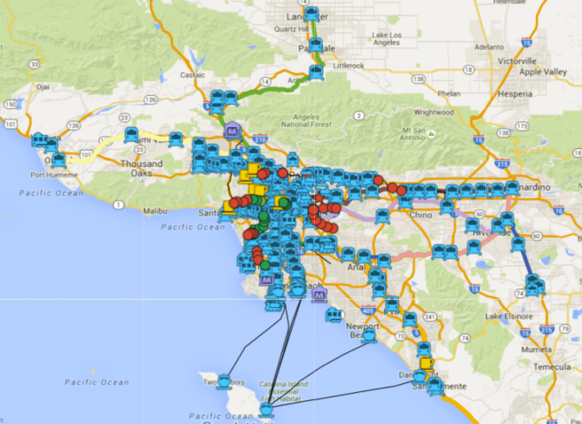
Metro operates four light rail lines, two subways, and two metro liners. There are currently 86 stations and 158.5 kilometers of rail although more are under construction — the Gold Line Foothill Extension just opened and the Expo Line Extension opens in May. Metrolink maintains 55 stations and their seven lines cover 624 kilometers.
Metrolink, too, is expanding, with the (39 kilometer Perris Valley Extension opening any day now. Los Angeles and Southern California is also served by the national service, Amtrak, national bus services, the ferry service Catalina Express (older than either Metro or Metrolink), two domestic airports, and one international airport (with two more in the region).
I made this train map for fun and because finding comprehensive rail maps online is surprisingly difficult. Furthermore, most rail maps are designed for clarity — which is nice — but removes a sense of the railways’ (and their stations’) surroundings. I’ve also included abandoned rail cars, model railroad clubs, novelty trolleys, &c. I didn’t include buses (aside from Metro Liners) here because there are 170 Metro bus lines — not to mention dozens of other transit providers. It would too cluttered (and too much work). I did include the ferries, however, in part to remind people that Los Angeles includes two large islands (Santa Catalina and San Clemente) and also to nudge Angelenos and visitors into thinking differently about public transit actually is.
This map is a joint venture of California Fool’s Gold, Nobody Drives in LA, and Pendersleigh & Sons Cartography. It is, like our public transit system, a work in progress. I realize that transit advocates (and opponents) are often passionate and particular so please bear with me and offer additions and corrections with kindness and not blunt, internet outrage. I endeavor to make corrections in a timely manner but I’m not too concerned with exact rail alignments down to the millimeter so if my casual but fairly comprehensive approach disappoints you, I encourage you to make your own map. Thanks! Oh, and if you want to explore a great Pacific Electric map, The Militant’s Pacific Electric Archaeology Map, click here).
*****
Eric Brightwell is an adventurer, writer, rambler, explorer, cartographer, and guerrilla gardener who is always seeking writing, speaking, traveling, and art opportunities — or salaried work. He is not interested in writing advertorials, clickbait, listicles, or other 21st century variations of spam. Brightwell’s written work has appeared in Amoeblog, diaCRITICS, and KCET Departures. His work has been featured by the American Institute of Architects, the Architecture & Design Museum, the Craft & Folk Art Museum, Form Follows Function, Los Angeles County Store, Skid Row Housing Trust, and 1650 Gallery. Brightwell has been featured in the Los Angeles Times, Huffington Post, Los Angeles Magazine, LAist, Eastsider LA, Boing Boing, Los Angeles, I’m Yours, and on Notebook on Cities and Culture. He has been a guest speaker on KCRW‘s Which Way, LA? and at Emerson College. Art prints of his maps are available from 1650 Gallery and on other products from Cal31. He is currently writing a book about Los Angeles and you can follow him on Facebook, Instagram, and Twitter.
Click here to offer financial support and thank you!


One thought on “Nobody Drives in LA — Los Angeles Train Map”