


With bicycles, buses, ferries, planes, rideshares, sidewalks, subways, taxis, and trains at Angelenos’ disposal, why would any sane person choose car dependency? Nobody Drives in LA celebrates sense and sensibility in transportation.
It was a warm February morning when I texted my brother if he’d like to walk along the route of the Metro Gold Line Foothill Extension from Pasadena to Azusa (much as we did the Crenshaw/LAX Corridor). Confused by a dream and cursed with a poor sense of distance, I assured him that at just six stops, it would be a shorter trek. I was wrong.
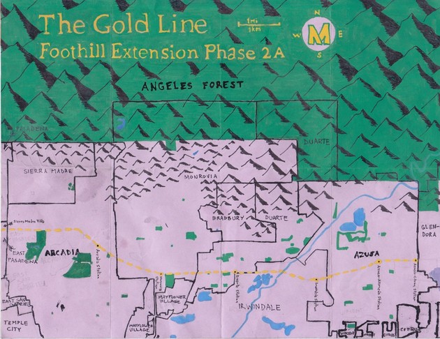
The Gold Line as it currently exists runs about 32 kilometers along two spurs. The Eastside Extension spur runs from Downtown‘s Union Station through Little Tokyo, and across the Eastside before terminating near East Los Angeles‘ border with Monterey Park. The older spur (Phase 1) passes from Union Station through Chinatown, across Northeast Los Angeles, and ends in the Hastings Ranch neighborhood of Pasadena.
THE FOOTHILLS
Construction on the Gold Line’s Phase 2 began in the summer of 2011 and is set to begin operation in 2015. It’s also known as “The Foothill Extension” because it passes through the so-called Foothill Cities situated along the southern face of the San Gabriel Mountain range in the San Gabriel Valley.
While the various city centers are all located near Interstate 210 (also known as the Foothill Freeway) and the future train line, one of the most attractive aspects of the communities for both visitors and residents is their close proximity to the wilderness areas of Angeles Forest, which contain mountains, rivers, wildlife and other attractions.
The highest peak in the San Gabriel Mountains is the 3068 meter tall Mount San Antonio (aka Mt. Baldy). The San Gabriel River drains a 1,847 square kilometer watershed basin extending from the San Gabriel Mountains, across the San Gabriel Valley, to the Pacific Ocean, and the foothills are carved with numerous tributary waterways.
SIERRA MADRE VILLA
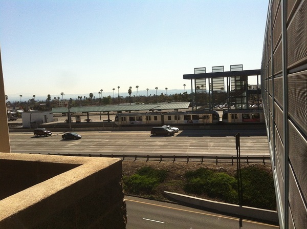
The current northeastern terminus of the Gold Line is the Sierra Madre Villa Station, which opened in 2003. It’s situated between the lanes of the 210 Freeway, east of Pasadena’s Downtown, Old Town, Civic Center, and thus most of the city’s commonly visited attractions. Hastings Ranch — Lower Hastings Ranch specifically — is mostly residential, although the vicinity around the station is characterized by the presence of several big box stores, chain restaurants and hotels. After disembarking from the train, we immediately headed east toward the first of the Foothill Extension stations. Since the Gold Line follows the right-of-way of the old Atchison, Topeka and Santa Fe Railway down the middle of a freeway, we opted to use Colorado Boulevard instead.
ARCADIA
After passing a cluster of car dealerships we entered Arcadia. Almost as soon as we did, the sidewalk ended. Anyone who’s ever navigated Arcadia on foot has likely been struck by its pedestrian-deterring lack of sidewalks. We therefore headed north to Foothill Boulevard, historically part of Route 66, and another street that runs parallel to the 210 and the train’s route.
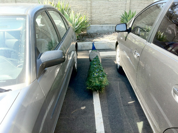
Arcadia’s motto is “Community of Homes,” although all the way up until 1965 every one of those homes were sold to exclusively to white Protestants. Ironically, the population has changed so much since then that today almost half the city’s residents are Asian-American (mostly Taiwanese and Chinese), resulting in its sometimes being referred to as “Arcasia.” It’s probably most famous as the home of Santa Anita Park, a thoroughbred racetrack. Adjacent to that (and well-known locally) is the sprawling Westfield Santa Anita Mall. It’s also home to the Los Angeles County Arboretum & Botanic Garden.
At 51 hectares, the arboretum is roughly the same size as the better-known Huntington Library‘s Botanical Gardens in nearby San Marino. Its grounds are patrolled by some 200 peafowl descended from those brought to Arcadia from India around 1880 by the notorious Elias Jackson “Lucky” Baldwin. Peafowl have long been a symbol of the city, and as we approached the gardens, we spied a peacock wandering the parking lot as if trying to remember where he’d left his car.
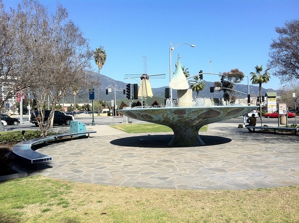
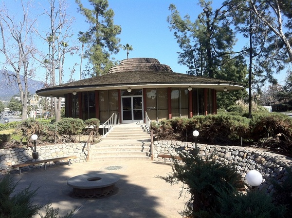
After briefly visiting the arboretum, we headed northeast along Huntington Drive, Arcadia’s so-called “Restaurant Row.” Another sidewalk-scarce stretch, it’s also home to a striking Chamber of Commerce building, the Arcadia Historical Museum, and the Santa Anita Golf Course (original site of the Santa Anita Racetrack and site US Army‘s Ross Field Balloon School during World War I). In Arcadia County Park we briefly checked out a fountain with a peacock motif, although equally eye-catching is the adjacent Denny’s with a windmill atop it — a reminder that it was formerly a Van de Kamp’s Restaurant.
Although we weren’t able to see it from our position, before arriving at Arcadia Station the 178 meter I-210 Bridge will carry the train over the eastbound freeway lanes and head southeast. Although it was conceived by British-born Minnesotan artist Andrew Leicester to suggest Tongva basket-making, photos of the biomechanical-looking structure remind me more of the dark, creepy designs of Swiss artist HR Giger.
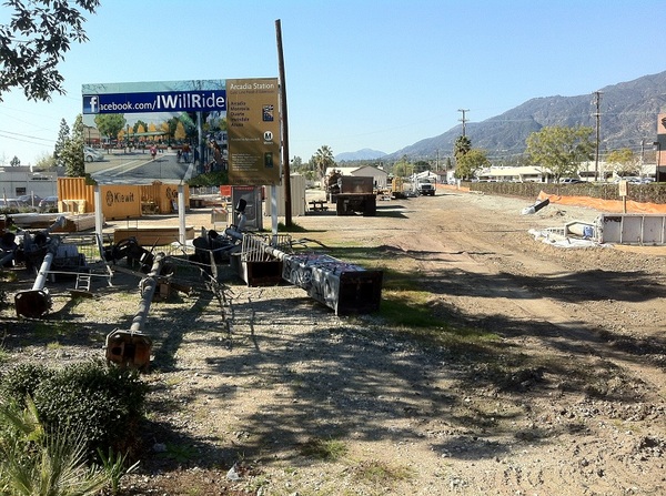
Arcadia Station will be located near the intersection of First Avenue and Santa Clara Street. There are a few parks nearby: Bonita Park, Eisenhower Park, and Newcastle Park. Also, although long ago (after the passing of Lucky Baldwin) Arcadians voted to ban the sale of alcohol, and despite Arcadia’s upscale character, there are several rather divey bars, including Bar One Hundred to One, First Cabin Bar, Bar Twist, and diviest of all in my estimation, Drinker’s Hall of Fame. Nearby places to dine include Bean Sprouts, Matt Denny’s Ale House, Claro’s Italian Market, The Derby, Domenico’s Italian, Phoenix, Young Dong, and others. One last possible destination for electric Blues-loving train riders is the Arcadia Blues Club.
MONROVIA
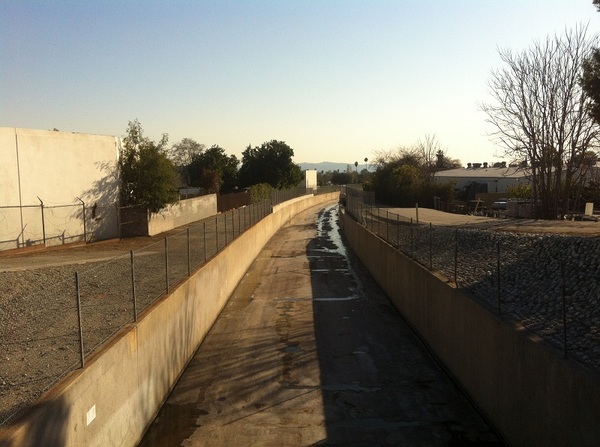
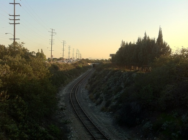
Since at this point the train’s route no longer travels between lanes of a freeway, we walked along its course toward Monrovia. There are no signs along the track informing travelers that they’ve left Arcadia, but the relatively modest homes and rustic vibe were obvious indicators. Shortly after crossing the Arcadia Wash (a tributary to Rio Hondo) we approached the site of the Monrovia Station.
Monrovia Station is being built near the intersection of Duarte Road and Myrtle Avenue. Right now the immediate surroundings are characterized by the presence of warehouses, light industry, box stores, and chain restaurants, but all that is set to change dramatically. Firstly, the construction of a large, mixed use transit-oriented district called Station Square Transit Village, which will incorporate the old Santa Fe Railroad station, used from 1926 until 1972, will surely change the landscape and atmosphere of the area. Secondly, a large maintenance yard is being built just a little to the east.
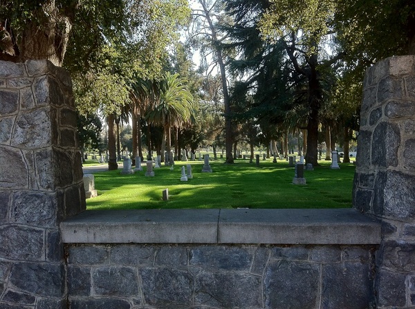
A few blocks north, Monrovia also has its own “Restaurant Row,” although it’s heavier on chains than the one in Arcadia. A bit further north from that is Monrovia’s quaint Old Town, which for much of the year hosts the well-attended Family Festivals on Fridays. Just east of the future station’s site is Live Oak Memorial Park, a cemetery established in 1887. Across the street from the graveyard, the train tracks turn due east, running parallel to Duarte Road, which we walked along.
DUARTE
Not long after we crossed Sawpit Wash we entered Duarte. After briefly stopping at quiet Aloysia Moore Park we continued east until construction prevented us from getting any closer to the site of Duarte Station. So we again detoured north.
Duarte Station will be located across from the City of Hope National Medical Center, a facility whose roots stretch back to 1914, when it was established by the Jewish Consumptive Relief Association. Another transit-oriented development is planned for that area, and there are already-extant attractions as well. Parks near the future station (some located within City of Hope) include Beardslee Park, Duarte Sports Park, Heritage Park, and Pioneer Park. There are a couple of restaurants in the vicinity, including Don Reyes and La Paloma, but the main commercial drag is situated some distance north along Huntington Drive.
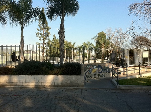
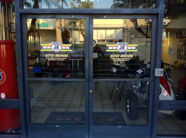
Heading east down Central Avenue we passed Duarte Skate Park, where 100% of kids were riding and doing tricks on scooters rather than skateboards (Duarte Scoot Park?). Further east, near the northern terminus of the 605 Freeway, we discovered the world headquarters of Justice Brothers, which houses a small collection of racing vehicles and classic cars referred to as the Justice Brothers Racing Museum. For the most part, the area between Huntington to the north, and the train’s course south of the freeway, is quiet and residential.
IRWINDALE
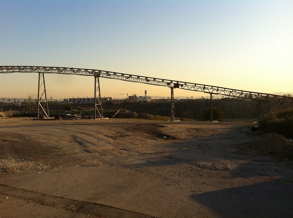
We passed by the wide San Gabriel River flood plain (although we saw no water flowing in the heavily-dammed river) and arrived in Irwindale. Since the 1950s, gravel quarries have been the major revenue source for the city (which is also sometimes called “Jardin de Roca“). Although some of the quarries are now closed or have been turned into landfills, the area has the bleak, scarred appearance of Mordor. The fantasy vibe seems appropriate because the nearby Santa Fe Recreation Area hosts the Original Renaissance Pleasure Faire (which, like all Renaissance festivals, more resembles a Fantasy England like Middle Earth than it does 14th Century Italy).
Irwindale also holds the distinction of being the least diverse city in the San Gabriel Valley (although its population as of 2010 was only 1,422 people). As with the fellow Foothill communities of Monrovia, Duarte, and Azusa, the largest ethnicity is Mexican-American, although interestingly, nearly 20% of Irwindale’s foreign born population is from Costa Rica.
Irwindale Station will be located near the intersection of Irwindale Avenue and Avenida Padilla. Cater-corner is the Miller Brewing Company‘s 45 hectare Irwindale facility, which opened in 1980. The megabrew annually churns out seven million barrels of mass-produced pale lager.
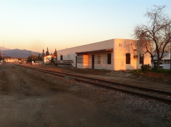
AZUSA
According to AL Kroeber‘s California Place Names of Indian Origin, the name “Azusa” derives from a Tongva place name, “Asuksa-nga,” meaning “Skunk Hill.” However, the dominant smell that we inhaled was from a more pleasant source — Bloomfield Bakers plant. Although not apparently among the range of products produced at the large facility, we both thought it smelled strongly of Cinnabons.
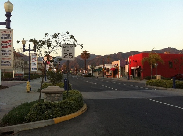
The westernmost of Azusa’s two planned train stations is Azusa-Alameda Station, which will be located in Downtown Azusa near a handsome station built in 1888 and remodeled in 1946. On the once-hugely popular Jack Benny Program, Mel Blanc, portraying a conductor, referred to the old Azusa station in a running gag where he’d announce, “Train leaving on Track Five for Anaheim, Azusa and Cucamonga!” even though those towns at no point ever shared a single train line. Trust me, it killed.
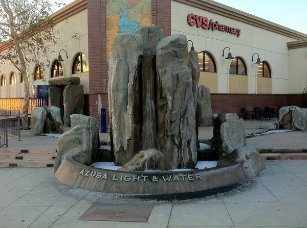
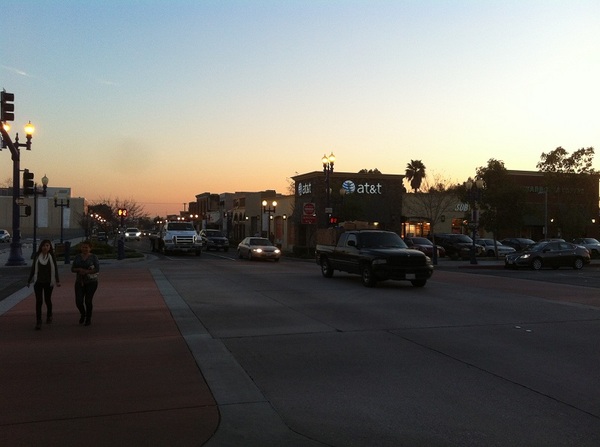
Like Old Town Monrovia, Downtown Azusa is quaint, charming, and possesses a small town feel. Most of the city’s civic buildings are in the immediate vicinity, as well as some Mexican (Almazan, Max’s, Taco King, Tapatio) and other (City Café and T Burgers) restaurants.
The final station planned for Phase 2A is Azusa-Citrus, to be located on the border with the city of Glendora and between the campuses of Azusa Pacific University and Glendora’s Citrus Community College. Near the stop there are several points of interest, including Azusa Pacific‘s Warehouse Theater and Citrus‘s Haugh Performing Arts Center, but we didn’t check any of that out because, due to lack of sidewalks and detours, we’d already walked more than sixteen miles and the sun had set. So instead we headed back across the valley on a surprisingly clean and comfortable Foothill Transit 187 bus.
THE NEXT PHASE
After Phase 2A is completed, the even longer (20 kilometer) Phase 2B will pass through Glendora, San Dimas, La Verne, Pomona, Claremont, and Montclair. Montclair Transcenter is already served by Metrolink‘s San Bernardino Line, Omnitrans, Foothill Transit, and Riverside Transit. The final phase will connect to Ontario Airport, making the Gold Line the longest light rail in the country but still connecting Pasadena to the Inland Empire by a ride that’s supposedly going to take just 35 minutes. Having learned my lesson the hard way, if I explore either of those phases, I’m probably going to do it by bicycle, not foot!
Support Eric Brightwell on Patreon

Eric Brightwell is an adventurer, essayist, rambler, explorer, cartographer, and guerrilla gardener who is always seeking paid writing, speaking, traveling, and art opportunities. He is not interested in generating advertorials, cranking out clickbait, or laboring away in a listicle mill “for exposure.”
Brightwell has written for Angels Walk LA, Amoeblog, Boom: A Journal of California, diaCRITICS, Hidden Los Angeles, and KCET Departures. His art has been featured by the American Institute of Architects, the Architecture & Design Museum, the Craft Contemporary, Form Follows Function, Los Angeles County Store, the book Sidewalking, Skid Row Housing Trust, and 1650 Gallery.
Brightwell has been featured as subject in The Los Angeles Times, VICE, Huffington Post, Los Angeles Magazine, LAist, CurbedLA, Eastsider LA, Boing Boing, Los Angeles, I’m Yours, and on Notebook on Cities and Culture.
Brightwell has been a guest speaker on KCRW‘s Which Way, LA?, at Emerson College, and the University of Southern California.
Brightwell is currently writing a book about Los Angeles.
You can follow him on Ameba, Duolingo, Facebook, Goodreads, Instagram, Mastodon, Medium, Mubi, the StoryGraph, and Twitter.


3 thoughts on “Nobody Drives in LA — Exploring the Gold Line’s Foothill Extension: Phase 2A”