


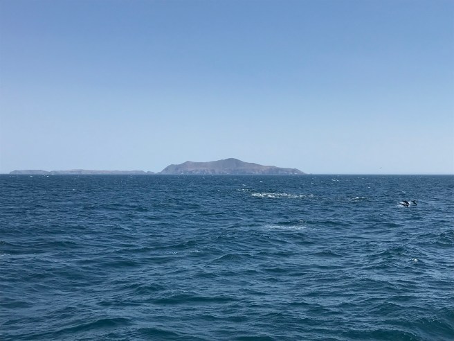
A few weeks ago, I visited Santa Cruz Island for the first time and spent a few days exploring and camping with some good folks from Maptime LA. I’ve only visited one of the Channel Islands previously, Santa Catalina Island, which I first visited with Una on my birthday and then again with Maptime LA. Not only is Santa Cruz Island the largest of the Channel Islands, at 250 square kilometers, it’s also the biggest island in all of California.
The Channel Islands are one of the richest marine biospheres in the world, which is why they’re often referred to as the “the Galápagos Islands of North America.” There are about 150 species endemic to the Channel Islands. In the past, California was wetter and cooler, and many species evolved that lived on both the mainland and the islands. As California grew drier and hotter, and sea levels rose, one island became four and the channel between them and the mainland widened. As the mainland grew hotter and drier, some species there went extinct whilst some on the islands remained and continued to evolve, like the Channel Islands mammoth, a mammoth which stood only two meters tall and the remains of which were first discovered in 1856.
Extant flora unique to the island includes Channel Island Oak, Greene’s liveforever, Island ceanothus, Island Rush Rose, Island Tree mallow, and a subspecies of Torrey Pine. Animals found nowhere else include Channel Islands Slender Salamander (the only endemic amphibian on the islands), Channel Islands Spotted Skunk, flightless katydid, Island deer mouse, Island fence lizard, Island Fox, Island gopher snake (the only endemic snake on the northern islands), Island Night Lizard, Storm-petrel, and woodland skipper. The Channel Island Foxes, despite their diminutive size and undeniable cuteness, were historically the apex predator of the Channel Islands. Whereas some island species, like the Island Scrub Jay, evolved to be larger than their mainland relatives out of competition with similar species, the foxes, not in competition with any other predators, grew smaller to require fewer resources.
There are also species and subspecies unique to just Santa Cruz Island, including the aforementioned Island Scrub-Jay (the only bird in the continental US endemic to a single island), Santa Cruz Island bush mallow, Santa Cruz Island gooseberry, Santa Cruz Island lacepod, Santa Cruz Island live-forever, Santa Cruz Island manzanita, Santa Cruz Island silver lotus, Whitehair manzanita, and Santa Cruz Island monkeyflower — although the latter is possibly extinct.
The oldest human remains thus far discovered in the Americas are two femora discovered on neighboring Santa Rosa Island in 1959. Through radiocarbon dating, they were determined to be roughly 13,000 years old. That was during the last ice age, when sea levels were 46 meters lower and the four northern Channel Islands connected as one, retroactively named “Santa Rosae” (or “Santarosae”). The bones belonged to a hunter-gatherer known as the Arlington Springs Man (or Woman). Hunter-gatherers settling the New World are now referred to as Paleo-Indians and thus, differentiated from later Native American cultures even though they were certainly their ancestors.
The Chumash are known to have called the Channel Islands home for at least 11,000 years. Their name for Santa Cruz Island is Limuw. According to their traditional beliefs, they were created on the islands by the Earth Mother, Hutash from the seeds of a magic plant. The Chumash were cold so Hutash’s husband, Alchupo’osh (Sky Snake), gave them fire by launching a bolt of lighting. The Chumash tended and preserved the fire and used to keep warm and to cook food. The fire’s smoke attracted the watchful condor, then all-white, who was blackened with soot when he got too close. When the islands grew too crowded, the noise of singing and dancing grew annoying to Hutash who thus created a rainbow bridge to the mainland by connecting Limuw to Tzchimoos, a tall mountain near Mishopshno (Carpinteria). Some of the Chumash who crossed the bridge fell into the channel and were transformed by Hutash into dolphins, which are therefore regarded as kin by the Chumash.
Of all Native Americans, only the Chumash, Tongva, and Mapuche of Chile are known to have possessed deep-seafaring boats, which the Chumash call tomol. The tomol were constructed from planks, reached lengths of ten meters, and held about ten passengers. The tomol-building Brotherhood of the Tomol disbanded in 1834. A new group was created in 1976 and their tomol, Helek, made the first inter-island journey since the 1800s. The Chumash Maritime Association was founded in 1996. In 1997, the group constructed a tomol called ‘Elye’wun, which in 2001 made the journey from the mainland to Limuw. I would love to be part of such a journey, but no one that I know shares my desire to row a plank canoe to a distant island.
The Chumash are believed to have settled and subsequently abandoned much of the mainland’s inland areas, including the Los Angeles Basin. The Chumash never developed agriculture but flourished as foragers and hunters. The traditional dietary stables of Santa Cruz Island’s Chumash included acorns, berries, tubers, island cherry, fish, shellfish, seabirds, and sea mammals. They used lemonade berries to make a beverage and traded with others to obtain chia, pine nuts, and deer meat.
They likely abandoned the inland after a prolonged drought. Around 3,500 years ago, the Tongva migrated to the region from the Sonoran Desert to the East. There are signs of pitched battles, probably between the Chumash and Tongva, on Santa Nicolas and San Clemente islands but by the time the Spanish arrived, the islands seem to have settled into a mostly peaceful existence. Remains of ten Chumash villages have thus far been discovered on Santa Cruz Island which is believed to have supported a permanent population of roughly 1,200. The largest village, Swaxil (Yshguagel), was located near the present-day location of Scorpion Ranch. Near Smuggler’s Cove was the village of Nanawani (Nanaguani). Located near the site of the main ranch was Hichimin. Near Prisoner’s Harbor was Kahas (also Xaxas or Cajats). Near Laguna Canyon was Shawa. In the interior, Liyam. Other villages included Ch ‘oloshush (Cholosos), L’alale (Lalale), L’akayamu (Lacayamu), Lu’upsh (Luupsh), and Mashchal (Maschal).
In 1542, Juan Rodriguez Cabrillo became the first Spaniard to site the island, which he labeled “San Lucas” on his map. Sebastián Vizcaíno was tasked, in 1601, with mapping the California coastline. Toward the end of 1602, he entered California and curiously renamed San Lucas (or Limuw) “Isla de Gente Barbuda” or, “Island of Bearded People.” During an overland expedition in 1769, Gaspar de Portolà y Rovira was supposedly presented with a staff previously lost by a priest and they rechristened the island “La Isla de Santa Cruz.”
In 1810, Mexico declared independence from Spain. It was granted recognition after their victory, in 1821. The Mexican government forcibly removed the Chumash from the island in 1822 and transformed it, for a time, into a penal colony. In 1839, it was granted to Captain Andrés Castillero who became the first of the island’s private owners. It was during this time that sheep and cattle were introduced to the island, which they grazed, decimating in the process the fragile chaparral scrubland in introducing destructive non-natives, many of which actively suppress the germination of seeds by natives.
The US conquered an enormous portion of Mexico, including the Channel Islands, in 1848 and in 1850 California was made a state. Land grants continued to be respected by the new power, however, and Santa Cruz Island remained in the hands of Castillero until 21 June 1857, when ownership passed to William Eustace Barron, a Mexican at the time living in San Francisco. During Castillero’s stewardship, an English physician named James B. Shaw was allowed to build a ranch home on the island from which he began raising Merino sheep for wool. By 1864, there were some 24,000 sheep roaming the island.
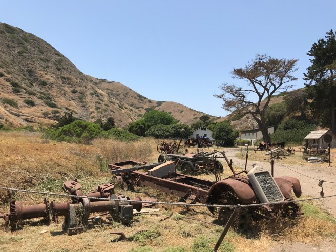
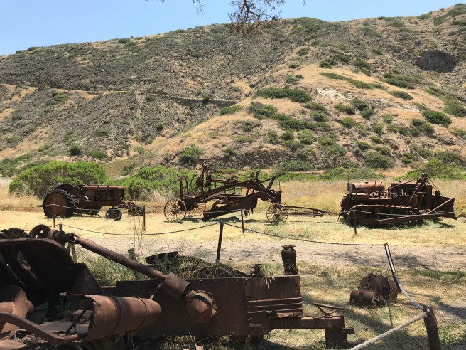
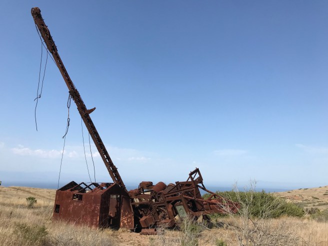
Investors from San Francisco formed the Santa Cruz Island Company in 1869 and assumed control of the island. Around 1880, company member Justinian Claire acquired sole ownership of the island. Under the Frenchman’s stewardship, the island was used to raise sheep, cattle, and over a dozen types of wine (Zinfindel was most prevalent). The ranch produced chickens, vegetables, fruits (cherry, citrus, fig, and pear), nuts (almonds and walnuts), and cheese, as well, used to feed blacksmiths, cobblers, and other mostly French and Italian ranch workers. Specialized satellite ranches with were developed and managed by various superintendents for the company. Scorpion Ranch produced hay and other grains and provided pasture lands. Tractors were brought to the island in 1918. Prohibition was launched in 1919, killing Ventura County’s largest wine operation, but the ranches continued, with the focus shifting almost entirely to sheep production in the east, and cattle everywhere else.
After the death of Claire in 1897, his children had fought one another over control of the island. Litigation between his offspring finally ended in 1932, the court declared the island should be partitioned. Aglae S. Capuccio and Edmund A. Rossi’s parcels on the east end of the island were merged by Claire’s granddaughter, Maria Rossi Gherini, and her husband, Ambrose, in 1932. The rest of the island remained divided between Arthur J., Delphine A., Fred F., and Helene A. Claire until 1937 when they all sold their parcels to rancher Edwin Stanton. The Stanton parcel was sold to the Nature Conservancy in 1978. In 1979, Congressman Robert J. Lagomarsino introduced a bill to create the Channel Islands National Park, which was signed by President Jimmy Carter on 5 March 1980. It wasn’t until 1997, however, that the National Park Service acquired full ownership from the Gherini family of the island’s east end. In 2000, the Nature Conservancy donated 8,500 acres (3,440 hectares) to the National Park Service, extending park management from about 10% of the island to 25%.
Decades of ranching and environmental devastation ravaged the island’s native wildlife. In the 1930s, Brown pelicans abandoned the island for offshore rocks, a few of which I spied from the beach. Bald Eagles and peregrine falcons were driven into local extinction in the 1950s by DDT. With them gone, smaller Golden Eagles migrated from the mainland and nearly drove the tiny Channel Island Fox into extinction by preying on them and feral pigs, which along with adult pigs continued to decimate the landscape and archaeological site. Peregrine falcons were introduced in 1983. In 1984, Scorpion Ranch was leased to a hunting organization to rid the island of pigs. The last of the sheep were rounded up and relocated in 1999. In 2002, Island foxes were re-introduced. Bald eagles were reintroduced in 2002 and began hatching on the island, once again, in 2006. The last of the Golden Eagles were relocated in Northern California in 2007. That same year, the last of the feral pigs were killed.
Flooding in the El Niño of 1997-1998 destroyed and damaged much of Scorpion Ranch, located as it is at the delta of a seasonal river. A campground, trails, and archeological sites were also affected. After the removal of native animals, efforts to re-establish native plants, which reduce erosion and otherwise support the native ecosystem, got underway. At the same time, work is being done to rid the island of non-natives like wild mustard, fennel, and range grasses. Some non-natives, mainly in the ranch areas, are preserved for their historical importance including eucalyptus, olive, pepper, and Monterey cypress trees. Native or not, when it’s hot and sunny you won’t mind the shade. In 2003, Marine Protected Areas were established around the park islands to preserve and restore marine populations.
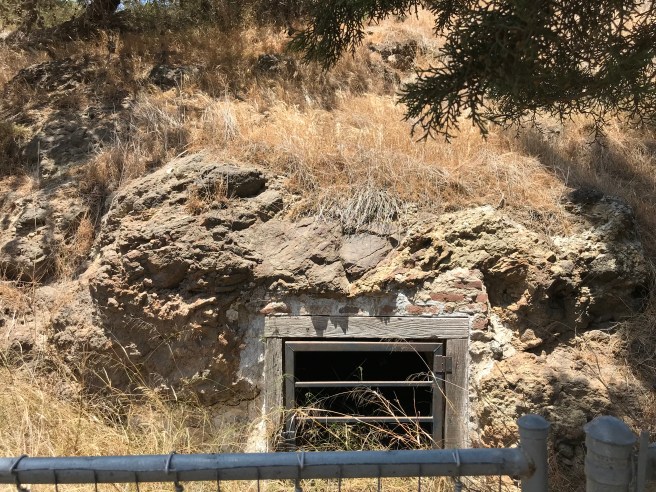
There are archaeological sites from various periods of the island’s history. There are the oldest shell middens in the Americas. From the ranch era, there are barns, a chapel, homes, and quite a few other buildings and structures scattered here and there. There are three airstrips: Unknown Airstrip, Christy Airstrip, and Santa Cruz Island Airport although most people arrive via boats operated by Island Packers Cruises.
Island Packers has been the primary transport agency to the northern Channel Islands since its launch in 1968 and I was impressed with the operation although there were a few issues on which I wasn’t clear before going to the island. Mainly, the website states that no single item may way more than 45 pounds (20 kilograms) and even though my bag only weighed about 20 pounds, I was worried that not being able to fit my tent inside would be an issue. It proved not to be, as there is apparently no limit to how many items one may bring — as long as they can fit under the deck. Of course, once on the island, you’ll want to make sure that you’re able to transport them to and from the campsite. Had I known that beforehand, however, I might’ve brought a second bag with some canned beer or a pouch of wine. Speaking of which, the beer selection on the boat was good and included canned macrobrews and Island Brewing Company on tap — although, on the way out to the island, rough seas lead me to opt for the canned option. The way back was smooth enough for a draught.
Many day visitors seem to content themselves by swimming at the beach or renting kayaks and snorkeling equipment from the concessionaire. Given the heat wave, I’d have loved to have gone snorkeling or swimming, but I was nursing a swollen, dressed wound from a cat attack (long story) and was advised to stay out of the ocean. There’s also a visitor’s center and one can poke around some of the old Scorpion Ranch structures and learn a thing or two.
By the way, other than snorkeling and kayaking equipment, the concessionaire is allowed to sell very little, including no food and drink. There’s running water at Scorpion Ranch’s campgrounds but anything else you might want to drink or eat you must bring yourself — and pack out the waste of. No campfires are allowed (you can pack a small stove) and storage containers are provided in which to prevent mice, foxes, and ravens from absconding with your food — which they will if left unattended — as some of our neighbors found when ravens flew off with their Hawaiian Sweet Rolls and boiled peanuts.
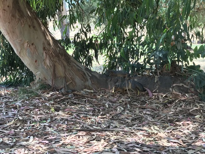
The assembled campers in our group had originally planned to map some of the trails for an open source competitor to Google Maps called Mapillary but the first night was extremely windy and hot… almost too hot to think or, it turned out later, to sleep. Additionally, there were issues with the 360 cameras and also it was just so exhaustingly hot and uncomfortably dusty, that we decided to relax as best we could after an evening hike to Potato Harbor. The next day was hot again and we relocated to a nearby group campground blessed with beautiful scenery, ample shade, eucalyptus-scented breezes, and playful Santa Cruz Island Fox kits. The final day I spent most of my morning just watching foxes, relaxing under trees, and relaxing on the beach in solitude except for when my peace was briefly disturbed by a young woman sneaking a cigarette away from her family.
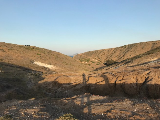
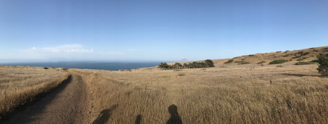
One of the primary attractions for most visitors, I assume, are the hiking trails. Before visiting I was disappointed to learn that 75% of the island is off-limits to visitors not invited by the Native Conservancy but after three days I felt as if I’d barely scratched the surface. The terrain was much more rugged and dramatic than I’d imagined — and hot. It was about 40°C when we disembarked and we cut a hike to Smuggler’s Cove short. Maybe next time I’ll camp at Del Norte Camp, near Prisoner’s Harbor. Ultimately I was kind of glad that so much of the island is inaccessible to most — it adds a bit of mystery.
I still want to visit all of the Channel Islands. As of 2018, San Clemente and San Nicholas are administered by the Navy and therefore the public is restricted from visiting them. Anacapa is a noisy island, foghorns and flocks of gulls compete with one another in an earsplitting contest. There’s limited transportation service to remote Santa Barbara Island no goods or services, which sounds quite daunting for someone not particularly adept at planning ahead. San Miguel Island sounds very mysterious, with its thick fog, terrific wind, and caliche forest. Santa Rosa Island is also renowned for its scenery — and, like most of the islands, is said to be an “exercise in preparation and self-reliance.” In the end, I might just return to Catalina or Santa Cruz albeit ideally when it’s a bit wetter, greener, and cooler.


5 thoughts on “California Fool’s Gold — Exploring Santa Cruz Island”