

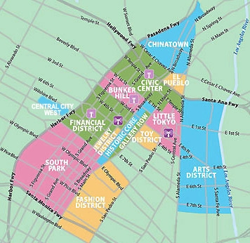
There is a casualness and imprecision practically intrinsic to Los Angeles. It’s only in this city that I’ve encountered people who aren’t sure what neighborhood they live in. What’s more, they seem undisturbed, it’s all “Los Angeles,” after all, an abstract city where many residents are seemingly less concerned with where they actually live than where they park their cars. Business owners would seem to customers to know where they’re located but often aren’t much better — thus the “Silverlake” location of Caffe Vita (located in Los Feliz), the Silver Lake location of Tomato Pie (in Franklin Hills, and Echo Bark (in Silver Lake).
It probably doesn’t help that so many neighborhood boundaries are only hazily defined. Angelenos often identify with parks or major street intersections. How far from the intersection of West Temple Street and North Beaudry Avenue do the boundaries of Temple-Beaudry (or Adams-Normandie, Central-Alameda, Florence-Firestone, Pico-Robertson, Pico-Union, Vermont-Slauson) extend? How far from South Central Avenue do the boundaries of the South Central neighborhood extend? What about Wilshire Boulevard and the Mid-Wilshire region? If you’re standing next to the jogging around Silver Lake Reservoir, you’re definitely in Silver Lake; if you’re floating in a paddle boat atop Echo Park Lake, you’re definitely in Echo Park… but what forms and where lies the boundary between the two neighborhoods? No two (native or non) Angelenos, media outlets, or even city departments ever seem to be in agreement.
The landscape of Los Angeles is constantly shifting. Chumash and Tongva place names join Spanish and English ones. A wave of immigrants can change a neighborhood like Wilshire Center into Koreatown, and within that, Little Bangladesh. Eager to be associated with Hollywood glamor, Lankershim became North Hollywood. Eager to be dissociated with North Hollywood, a section of the neighborhood becomes Valley Village. Eager to dissociate with both, another section becomes Sherman Village.
As a neighborhood cartographer, these debates both amuse and vex me.
ANGELENO HEIGHTS vs ANGELINO HEIGHTS (vs ANGELEÑO HEIGHTS)
For over a century after its foundation, Spanish was the primary language spoken in
the pueblo of Los Angeles. The anglicization of Los Angeles had been underway for a decade but was accelerated by the arrival stubbornly English-speaking Middle Westerners and Easterners who swarmed to Los Angeles in the 1870s.
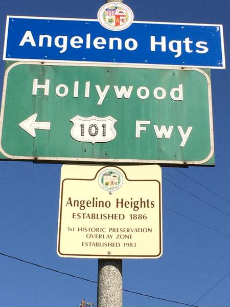
Still, when one of Los Angeles’s first suburbs was established in 1886, maps labeled it “Angeleño Heights,” even though the letter “ñ” doesn’t exist in English. Newspaper advertisements almost always spelled the neighborhood’s name as “Angeleno Heights,” but as early as 1887, it was often also referred to as “Angelino Heights.” For whatever reason, the misspelling eventually became more common and when the Department of Transportation installed neighborhood signs, they read “Angelino Heights.” Neighborhood activists got the department to replace the misspelled signs but it’s still the spelling used by Curbed LA, the Echo Park Historical Society, LAist, Los Angeles Magazine, the Los Angeles Times, the Los Angeles Conservancy, and Wikipedia. If you search online for “Angeleno Heights,” using Google, the website will inform you that they’re “Showing results for Angelino Heights.”
ANGELES MESA vs ANGELUS MESA
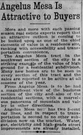
In the late 19th and early 20th centuries, “Angelus” was fashionably employed as a poetic (or pretentious) alternate spelling of “Angeles.”A musical organization called the Angelus Club was formed in 1899. The Angelus Hotel opened in 1901. Angelus Avenue was created around 1906. Angelus Temple was built in 1923. Angelus Funeral Home incorporated in 1925.
The Angeles Mesa Land Company formed in 1910, to develop a tract in Southwest Los Angeles. Although they first marketed their tract as Angeles Mesa, less than a year later it was marketed as Angelus Mesa. Nevertheless, when a library opened there in 1929 it was named the Angeles Mesa Branch Library. Angeles Mesa Park also went with the original spelling. However, when the City Council moved to recognize official boundaries of the neighborhood in 2005, the city clerk used both spellings in the same document. When the DOT signs went up, though, they read “Angeles Mesa.”
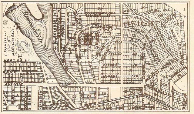
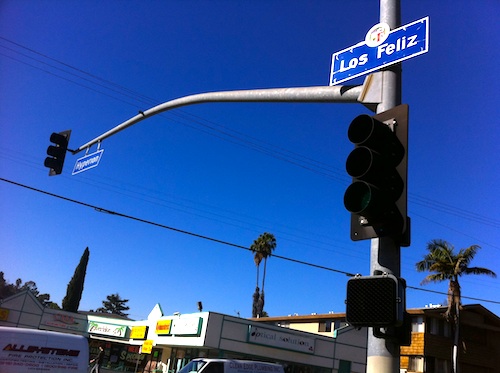
LOS FELIZ vs LOS FELIS (vs LOS FELIX)
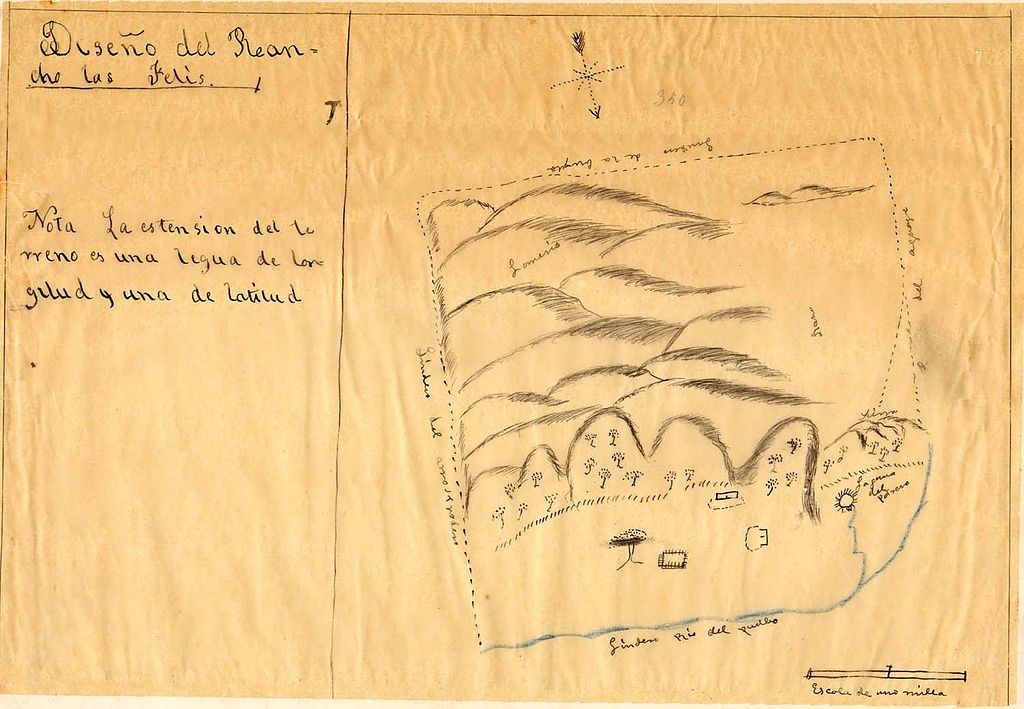
The pronunciation of “Los Feliz” is the subject of debate but the spelling is not, although it has changed over the years. However, its namesake, Vicente Felis, spelled his family name with an “s” — except when he spelled it with an “x.” Rancho Los Felis was granted to the corporal in 1795, spelling it thus. Although grammatically incorrect, Anglos began hypercorrecting “Los Felis” to “Los Feliz” as early as 1860.
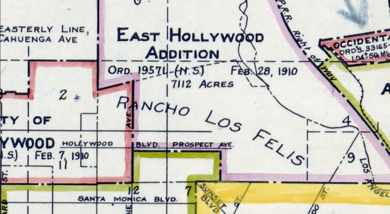
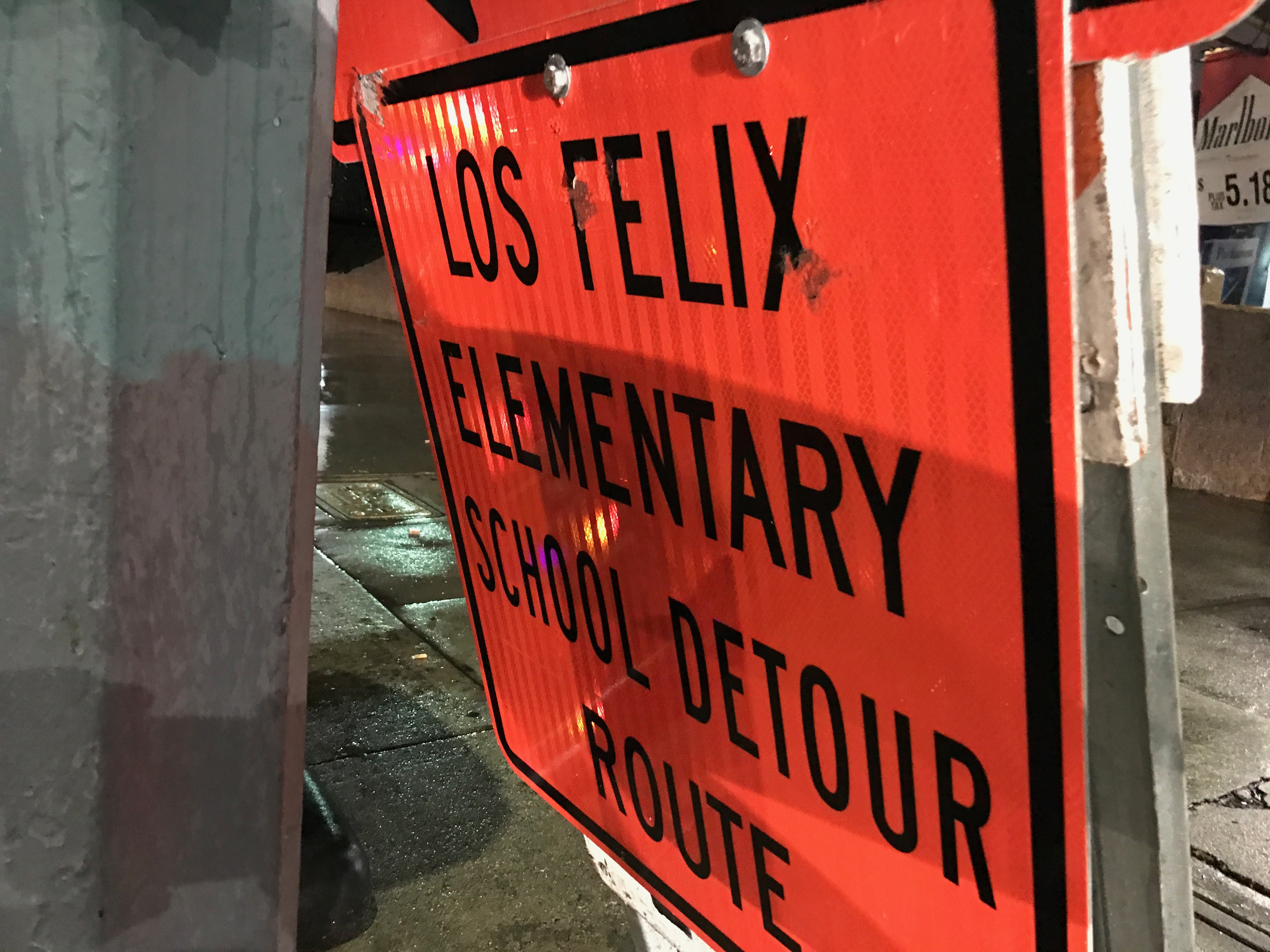
Still, as late as 1916, maps still occasionally depicted the land as “Rancho Los Felis,” six years after its annexation by Los Angeles as part of the East Hollywood Addition. The neighborhood which developed there was always referred to as Los Feliz, though, so imagine my surprise when I spotted a detour sign last month referring to “Los Felix Elementary School.”
MANCHESTER SQUARE vs MANCHESTER SQUARE
There are two neighborhoods called Manchester Square in Los Angeles. The original Manchester Square is an area of the Westchester neighborhoods, located just east of Los Angeles International Airport (LAWA) that was mostly developed in 1948 and ’49. In preparation for the expansion of Los Angeles International Airport (LAX), LAWA began buying and demolishing homes in the neighborhood. After the September 11 Attacks, Mayor Hahn advocated turning the neighborhood into a sprawling, rental car lot and prohibiting all vehicle traffic to the airport. Culver City, El Segundo, and Los Angeles County all sued the city to prevent the implementation of the plan, known as Alternative D. Meanwhile, LAWA keeps buying homes and demolishing them and today the neighborhood is mostly comprised of empty streets and empty, fenced-off lawns… and automobile-oriented LAX remains the major airport in a major city with no rail access (yet) — so Manchester Square is most popular as a parking spot for motorists awaiting the arrival of friends who for whatever reason are unwilling to use the free LAX Shuttle & Airline Connection, a taxi, a shuttle, a ride-hail, or the LAX FlyAway.
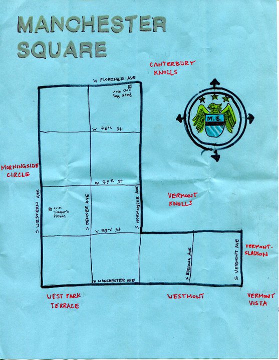
Five kilometers east of the mostly abandoned Manchester Square and separated by the city of Inglewood is another neighborhood named Manchester Square. Although a few decades older than the Westchester neighborhood, the neighborhood on South Los Angeles’s Westside existed without a widely used name for most of its existence. Although nameless, its intersection of Florence and Normandie was well known for decades as the the home of Art’s Chili Dog, the birthplace of the chili dog.
Later Manchester Square and the intersection were better known as the home of the notorious 8 Tray Gangster Crips set, which formed in 1974. It was there that Sanyika Shakur (né Kody Dehjon Scott) acquired the nickname and reputation of “Monster.” It was also there that the serial killer and rapist known as “The Grim Sleeper,” lived and found many of his victims. Although the 1992 Los Angeles Riots broke out simultaneously in several parts of the city, after the on-air beatings of Reginald Denny and Fidel Lopez at the intersection of Florence and Normandie cemented the intersections notoriety.
In 2000, the Eighth District Empowerment Congress initiated the “Naming Neighborhoods Project,” in part to foster a sense of pride and identity in areas of the city more often referred to simply as”the ‘hood” or “the ghetto.” In the years that followed the project established the new neighborhood designations of Arlington Park, Baldwin Vista, Broadway Square, Cameo Plaza, Canterbury Knolls, Century Cove, Century Palms, Crenshaw Manor, King Estates, Magnolia Square, Morningside Circle, University Expo Park West, Vermont Vista, West Park Terrace, and — since apparently no one else was really using it anymore, Manchester Square.
ROSE HILL vs ROSE HILLS
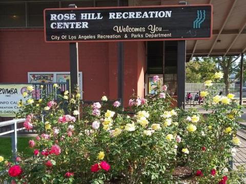
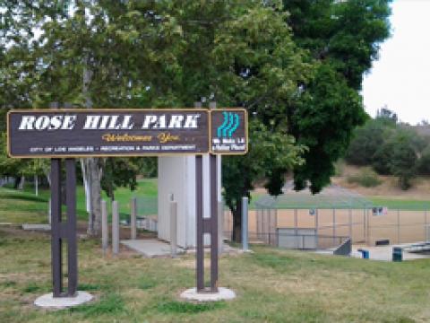
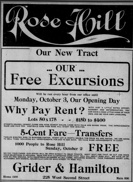
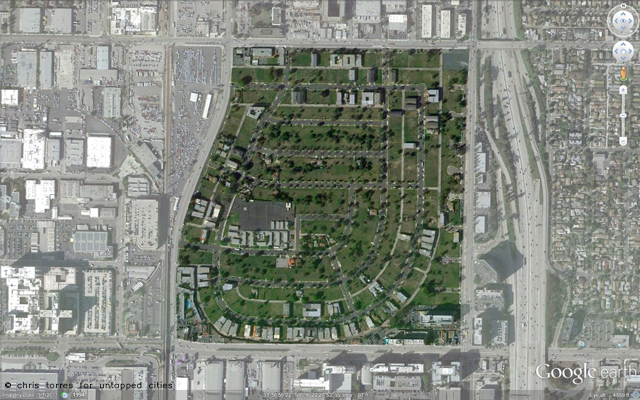
The titular hill of the Rose Hill neighborhood is one of the hills which comprise the Repetto Hills. The neighborhood, located on land granted by Mexico to Juan Ballesteros, was part of Rancho Rosa Castilla. In 1903, Leroy M. Grider developed a streetcar suburb there as the Rose Hill Tract. Rose Hill School opened in 1909. Our Lady of Guadalupe – Rose Hill was established in 1921. The neighborhood was also home to Rose Hill Park, the Rose Hill Pharmacy, Rose Hill Courts public housing project, the Rose Hill Boys gang, Rose Hill Drive, and the Rose Hill Recreation Center. And yet, when signs were installed around 2005, the signs referred to a plural “Rose Hills.”
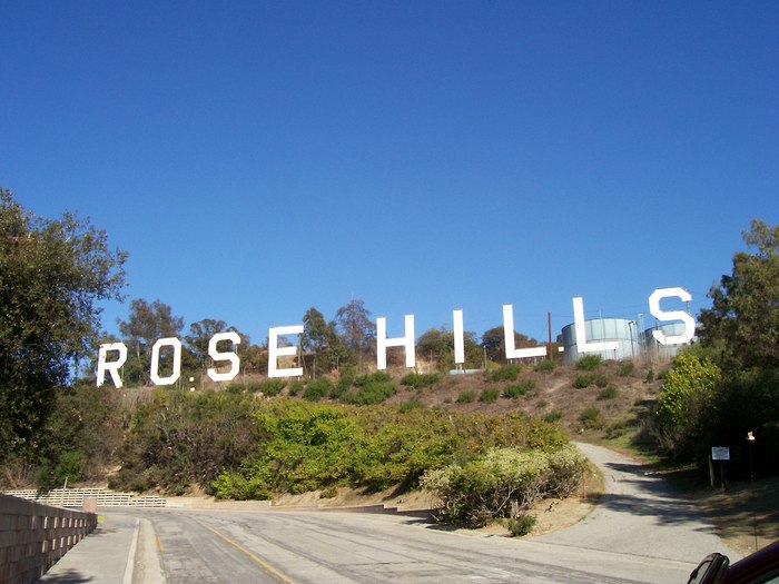
It wouldn’t be so annoying if there were more than one hill named Rose Hill in the chain… or if there wasn’t already a community of that name, twenty kilometers east. When the town of Whittier incorporated as a city in 1898, the unincorporated area north of town, nestled in the Puente Hills, was often referred to simply as North Whittier. However, with the opening of the Rose Hills Memorial Park in 1914, people began more often referring to the adjacent community as Rose Hills. More than a century later, the cemetery covers about a quarter of the community’s area and is home more than three times as many humans (albeit dead) as the community which nearly everyone knows as Rose Hills… and yet those DOT signs still announce Rose Hills over on the Eastside.
SILVER LAKE vs SILVERLAKE
The Silver Lake neighborhood is often spelled as one word, “Silverlake.” Defenders of the two word spelling might point to a neighborhood like Toluca Lake as precedent, whilst the one-worders might just as easily point to Westlake. Both spellings are nearly as old as the reservoir after which they’re named.
Before there was a Silver Lake Reservoir, the valley was known as Ivanhoe Valley, after the tract established in 1877 just north of Los Angeles’s original city limits. Nearby Edendale was subdivided to the east in 1903. The Silver Lake Reservoir was named after Herman Silver, a member of Los Angeles’s first Board of Water commissioners. The reservoir was completed in 1907, after which the neighborhood came to gradually be more often referred to as Silver Lake as the tract names “Ivanhoe” and Edendale faded from everyday usage (although a restaurant called Edendale Grill & Mixville Bar opened in Ivanhoe (and thus not Mixville or Edendale) in 2005).
In every decade since, the double word spelling has appeared in print more often than the single. However, in 1913, just six years after the completion of the Silver Lake Reservoir (and incidentally, the year Herman Silver died), the Los Angeles Herald referred to the neighborhood as the
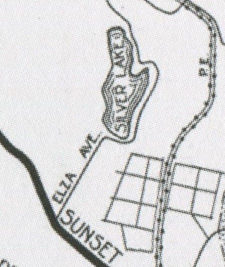
“Silverlake district” in a notice regarding a “lost or strayed… Fox Terrier bitch” from a home at 1553 Micheltorena. In the 1920s, when Elza Avenue was renamed, it was renamed Silverlake Boulevard.
In official usage, the two word spelling almost always prevails but in business names and colloquial use, the one word spelling remains common. Some businesses, like the Silver Lake Lounge/Silverlake Lounge, or SilverLake Ramen cleverly appease both camps.
SOUTH PARK vs SOUTH PARK
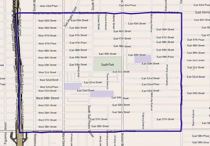
South Park is a neighborhood located just south of South Central on South Los Angeles’s Eastside. It was developed in 1899 and is home to the famed Dunbar Hotel.
As South Central was so known for its main street, South Central Avenue, South Park originally shared a name with South Park Avenue, long since renamed Avalon Boulevard. The park known as South Park remains, however, and residents still refer to the neighborhood as such.
Neither the pre-existence of a South Park neighborhood just 2.5 kilometers away nor the lack of any park troubled developers in the 1970s, who co-opted the name for their Pico-Union adjacent project. Granted, the centerpiece was intended to be a large park, but like so many plans, the park never came to fruition. 37 years later, are parkless (but for tiny Grand Hope Park) mini-Las Vegas that’s home to L.A. Live, the Staples Center, and the Los Angeles Convention Center is still holding onto the “South Park” designation.
WEST ADAMS vs WEST ADAMS
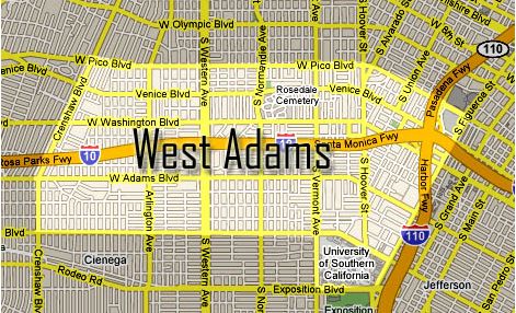
West Adams is an historic district of Los Angeles named after what was once its primary thoroughfare, West Adams Boulevard (then West Adams Street), and located just west of the campus of University of Southern California and Exposition Park. In the late 19th and early 20th centuries, it was home to some of the city’s wealthiest residents and grandest mansions. West Adams was an informal designation which included many subdivisions and tracts like Adams Street Homestead, West Adams Heights, Grand View Heights, and Arlington Heights. After the desegregation of Los Angeles, the demographics of the changed. The construction of the Santa Monica Freeway tore through the community in the 1960s, supplanting West Adams Boulevard as the district’s primary motorway and effectively cutting the community into two pieces.
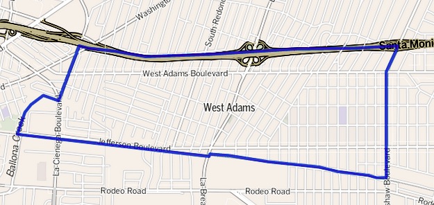
West Adams Boulevard stretches all the way from Main Street (where it becomes East Adams) to Culver City, a distance of nearly ten kilometers. The neighborhood north of Baldwin Hills was mostly developed in the 1920s and is located along West Adams Boulevard; however, I’ve yet to find any source historically referring to the area as West Adams (Du Ray Place was one of the few area tracts given more than a mere number). Regardless, in 2001 area residents formed the West Adams Neighborhood Council there. In the other corner are the West Adams Heritage Association (founded in 1983) and others. Not even the Los Angeles Department of Transportation and the Los Angeles Department of City Planning can reach an agreement on which is West Adams — the definitions of those two departments don’t even border one another.
Support Eric Brightwell on Patreon

Eric Brightwell is an adventurer, essayist, rambler, explorer, cartographer, and guerrilla gardener who is always seeking paid writing, speaking, traveling, and art opportunities. He is not interested in generating advertorials, cranking out clickbait, or laboring away in a listicle mill “for exposure.”
Brightwell has written for Angels Walk LA, Amoeblog, Boom: A Journal of California, diaCRITICS, Hidden Los Angeles, and KCET Departures. His art has been featured by the American Institute of Architects, the Architecture & Design Museum, the Craft Contemporary, Form Follows Function, Los Angeles County Store, the book Sidewalking, Skid Row Housing Trust, and 1650 Gallery. Brightwell has been featured as subject in The Los Angeles Times, Huffington Post, Los Angeles Magazine, LAist, CurbedLA, Eastsider LA, Boing Boing, Los Angeles, I’m Yours, and on Notebook on Cities and Culture. He has been a guest speaker on KCRW‘s Which Way, LA?, at Emerson College, and the University of Southern California.
Brightwell is currently writing a book about Los Angeles and you can follow him on Ameba, Duolingo, Facebook, Goodreads, Instagram, Mubi, the StoryGraph, and Twitter.


The pronunciation of Los Feliz is not subject to debate. It’s pronounced:
“Laahs FEElis.”
(We’re not in Spain or Latin America, of course. And I am one who has been in/near/by there long enough to know.)
And the “X” I strongly suspect, is an incompetent/lazy City Street Services worker’s typo; who along with the rest of them, only cares about one thing.
LikeLike
Or maybe the “X,” is someone’s protest to the prevailing pronunciation. Power sometimes does “funny” things to people.
LikeLike