


If you can’t see the forest for the trees, Los Angeles might only seem like an exclusively horizontal city. The fact of the matter is, however, that no city on earth has greater difference in elevation, from below-sea-level Wilmington to 1,544 meter tall Mount Lukens. Tallest in the county is Mount San Antonio but even the gentlest chains of rolling hills dwarf the tallest artificial structures most “vertical” cities stake their reputations upon.
*****

Radio Hill is a low hill located within Elysian Park and part of the Elysian Hills, a small chain of sandy siltstone landforms with minor imbedded conglomerate that stretch from the Santa Monica Mountains (Hollywood Hills) in Griffith Park down to Downtown’s Bunker Hill.

Radio Hill is located between Solano Canyon to the northeast, Elysian Park and Dodger Stadium to the northwest, Chinatown to the southwest, and Los Angeles State Historic Park (“the Cornfield”) and Dogtown to the southeast.

Before the arrival of humans, Radio Hill and the surrounding area was home to California black walnuts, bobcats, California Kingsnakes, Coastal Whiptails, garter snakes, gopher snakes, grizzly bears, California mountain Kingsnakes, mountain lions, oaks, steelhead, sycamores, Western fence lizards, and other forms of life. At least 13,000 years ago the ancestors of the Chumash arrived in the area, but ultimately settled primarily along the coast and Channel Islands. Some 10,000 years later the Tongva arrived from the Sonoran Desert to the east and became the dominant nation within the Los Angeles Basin.
California was claimed by the Spanish Empire in 1542 but it wasn’t until the 18th Century that the Spanish Conquest really kicked off. In 1769 explorer Gaspar de Portolà embarked an overland exhibition, camping at the base of Buena Vista Hill (located on the other side of Solano Canyon) on 2 August of that year. The Spanish founded El Pueblo de Nuestra Señora de Los Angeles de Porciuncula on the banks of the Los Angeles River in 1781 and the pueblo was granted four square leagues of territory. Radio Hill lies within those borders although if it had name, it wasn’t “Radio Hill” as the word “radiophone” wasn’t coined until 1881.
Although it’s location near the center of the growing town made it desirable, its rugged terrain prevented, for the most part, its being developed and on 5 April 1886 it was set aside as the Elysian Park. It is not, as if often stated, either Los Angeles’s oldest park (that would be Pershing Square) nor its second largest (that would be O’Melveny or Griffith, if one excludes these 36 square kilometer Topanga State Park for not being located entirely within the city).


Radio Hill was separated from a large part of Elysian Park by Cemetery Ravine, named after the Calvary and Hebrew cemeteries and now mostly lying under the parking lot of Dodger Stadium. Now it’s separated by the Arroyo Seco Parkway, formerly Figueroa Street (thus the Figueroa Street Tunnels). By the time of its establishment as a park, most of the walnut and oaks had been chopped down. From 1886 until 1892 private organizations working with the city parks commission planted over 150,000 trees in the park and Radio Hill still boasts some dense eucalyptus groves and other species.

The name “Radio Hill” was probably first applied to the landform in the 1930s. In 1929 Los Angeles Police Department Chief of Police James E. Davis began exploring the possibilities of radio as a law enforcement tool. His successor, Roy Edmund Steckel, assumed the office of Chief of Police on 30 December 1929 and it was under his watch that the LAPD was granted its first radio license from the Department of Commerce Radio Bureau.
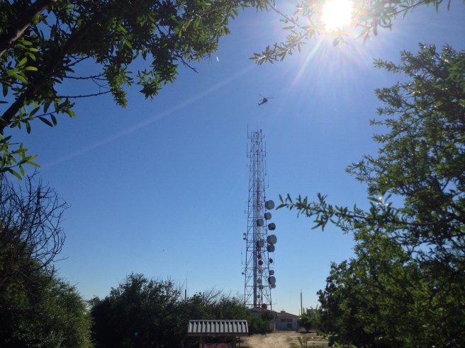

On 1 May 1931, the LAPD began transmitting with the call letters KGPL. In 1949, the Federal Communications Commission changed the callsign to KMA367. Today the primary callsign is KJC625 and the tower still stands above a small building at 1266 Stadium Way.
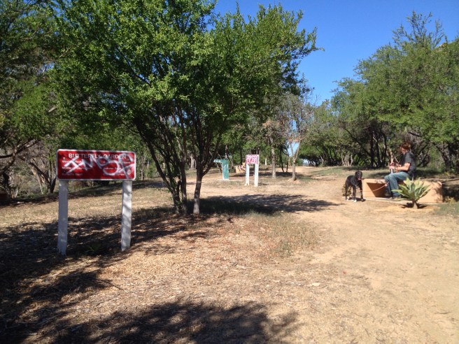

In the 1990s, the Radio Hill Gardens were installed atop the hill, supposedly to showcase native plants. Underneath layers and layers of tags, signs name autumn sage, California fuchsia, coastal rosemary, Mexican bush sage, monkey flower, Monterey ceanothus, scrub oak, and Western redbud. I mostly noticed small agave and non-native jade plants, which looked as if they’d been planted by guerrilla gardeners (perhaps members of Save Elysian Park) and recently watered.

Despite these efforts, today Radio Hill feels isolated, degraded, and neglected. I stared at a hole cut into a fence and a well-trodden trail next to some grocery carts and was reminded of Cormac McCarthy’s post-apocalyptic novel, The Road. At that moment my friend Matt remarked that the whole scene reminded him of something out of the television series, The Walking Dead. It’s a shame that it’s in such run-down condition because it is located next to green space-deficient Downtown and affords some nice views.


Getting to Radio Hill wasn’t that easy. There is one sign that I’ve passed heading to the Arroyo Seco Parkway but the nearest parking is on the streets of Solano Canyon or Chinatown. The nearest bus stop to the Stadium entrance is Broadway / Bishops (#11902) and nearest bus stop to the Amador entrance is Broadway / Solano (#11914). Both are served by Metro’s 28, 45, and 83 lines as well as LADOT’s DASH Lincoln Heights/Chinatown bus.
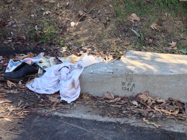
The permanently locked gates are easily enough circumnavigated on bicycle or foot but there’s a huge amount of broken glass and garbage strewn throughout much of the park and especially near the roads, which have no signs stating their names. As we explored the heavily trafficked trails, they all seemed to take us not to butterfly gardens or native plant showcases but rather to one of several shantytowns. I thought about referring to them as homeless “camps” but “camp” implies a temporary shelter and these makeshift slums had drainage ditches, fences, and an overall appearance of semi-permanence.

At the top of the hill an open fire hydrant hemorrhages water into a pool in which a bottle of shampoo and a tube of toothpaste bobbed next to some apples and empty water cooler jugs. At least one of the shanties was guarded by a territorial, off-leash pit bull who persuasively ushered us out of the park.
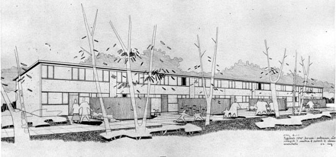
The sight of these dilapidated homes reminded me of the fact that this hill and hills nearby were the site of the infamous Battle of Chavez Ravine. Under the National Housing Act of 1949 the the Los Angeles Housing Authority received funding to build a public housing development named Elysian Park Heights and designed by noted architects Richard J. Neutra and Robert E. Alexander.
In 1952 and ’53 the makeshift communities in Elysian Park were cleared as the city both purchased property and seized it. Then, in 1953, with the support of the right wing group Citizens Against Socialist Housing (CASH), Republican mayor Norris Poulson was elected on a platform based largely on opposition to providing housing for war veterans, the elderly, and poor on the grounds that to do so would be “un-American.” Elysian Park Heights were never constructed and instead the land set aside for them was covered with a privately owned parking lot and baseball stadium and opponents of socialism can take comfort in the fact that our country still has a population of over 600,000 homeless.
FURTHER READING
- Elysian Transients
- From Worthless Land to Semi-Wild Paradise: The Origins of Elysian Park
- Radio Hill Gardens
- The Road to Radio Hill – Part One
- The Tattered Radio Hill Gardens
*****
Eric Brightwell is an adventurer, writer, rambler, explorer, cartographer, and guerrilla gardener who is always seeking writing, speaking, traveling, and art opportunities — or salaried work. He is not interested in writing advertorials, clickbait, listicles, or other 21st century varieties of spam. Brightwell’s written work has appeared in Amoeblog, diaCRITICS, and KCET Departures. His work has been featured by the American Institute of Architects, the Architecture & Design Museum, the Craft & Folk Art Museum, Form Follows Function, Los Angeles County Store, Skid Row Housing Trust, and 1650 Gallery. Brightwell has been featured in the Los Angeles Times, Huffington Post, Los Angeles Magazine, LAist, Eastsider LA, Boing Boing, Los Angeles, I’m Yours, and on Notebook on Cities and Culture. He has been a guest speaker on KCRW‘s Which Way, LA? and at Emerson College. Art prints of his maps are available from 1650 Gallery and on other products from Cal31. He is currently writing a book about Los Angeles and you can follow him on Facebook, Instagram, and Twitter.
Click here to offer financial support and thank you!


One thought on “Mist & Iron — Visiting Radio Hill”