

If you, like me, are a regular listener to the Conan O’Brien Needs a Friend podcast — especially the Summer S’mores series — you have no doubt heard Conan joke, um, more than once, about the vast distances and difficulties he has to overcome in order to get from his Westside home to Sona‘s in remote Altadena. Conan would have the listener believe that the not insignificant journey of just over 30 miles (52 kilometers for the rest of the world) requires booking passage on an ocean liner, hiring a sherpa, and changing camels no fewer than three times. From my car-free vantage point in Silver Lake, both of their neighborhoods appear dim and distant — but it its Conan’s neighborhood, not Sona’s (nor Matt‘s, for that matter), that is harder to reach on foot, by bike, or using mass transit — the modes of transportation favored by us regular, non-showbiz folk.
That said, listeners outside of Los Angeles — while used to Conan’s occasional exaggerations — probably have little grasp of Los Angeles County‘s geography. I know when I first came to Los Angeles that I asked my Angeleno friend, as we perused the racks at Poobah Records, if we could please walk to the beach afterward. He said, “no,” because Pasadena wasn’t within walking distance of the beach. I assumed that he was just being a typical carbrained Angeleno… because the song “The Little Old Lady (from Pasadena)” was by Jan & Dean… who, my reasoning continued, were a surf-pop band. What do surf-pop bands sing about? Beaches. Ergo Pasadena must be within walking distance from a beach. I see now that such a walk would have taken us a mere nine hours and fourteen minutes (plus breaks for food, water, and bathrooms). I rest my case.
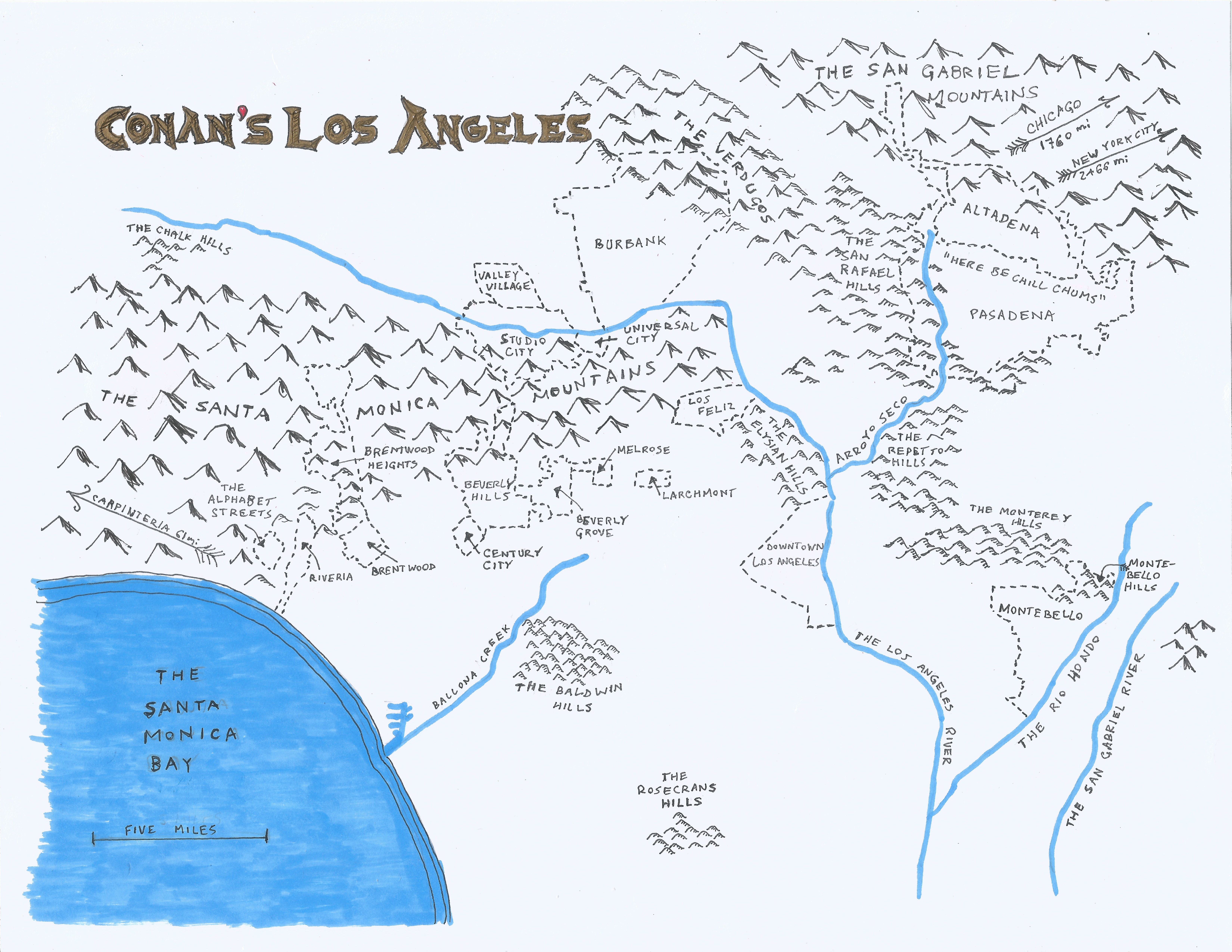
As Los Angeles’s official neighborhood czar and fantasy cartographer, I therefore felt compelled to create my map of Conan’s Los Angeles for the benefit of the listener as unfamiliar with Los Angeles prior to my having moved here. Conan’s Los Angeles, as I’ve interpreted it, includes places where he’s lived, places where his offices have been located, studios where he has recorded television programs and podcasts, and neighborhoods where he likes to eat sushi — that sort of thing. It does not include the whole county, which is literally larger in size than Qatar, Jamaica, Lebanon, and Puerto Rico. Los Angeles stretches 139 miles from the southern tip of San Clemente Island in the south the the northern tip of Oban in the north… and 74 miles from Decker in the west to Mount San Antonio in the east. Although he travels the world for Conan Without Borders, there is no record, written or otherwise, of Conan having ever been to any of those places in Los Angeles. Most Angelenos haven’t. No shade but most Angelenos couldn’t even located any of them on a map. No prize awaits anyone who can. So, with the aid of this map, you can now hopefully comprehend the perils of Conan leaving the Shire to head to the San Gabriel Valley and back again.
The map is fan art. I do not claim to own, have invented, be endorsed or affiliated with either Conan O’Brien or Conan the Barbarian.
Support Eric Brightwell on Patreon

Eric Brightwell is an adventurer, essayist, rambler, explorer, cartographer, and guerrilla gardener who is always seeking paid writing, speaking, traveling, and art opportunities. He is not interested in generating advertorials, cranking out clickbait, or laboring away in a listicle mill “for exposure.”
Brightwell has written for Angels Walk LA, Amoeblog, Boom: A Journal of California, diaCRITICS, Hey Freelancer!, Hidden Los Angeles, and KCET Departures. His art has been featured by the American Institute of Architects, the Architecture & Design Museum, the Craft Contemporary, Form Follows Function, the Los Angeles County Store, Sidewalking: Coming to Terms With Los Angeles, Skid Row Housing Trust, the 1650 Gallery, and Abundant Housing LA.
Brightwell has been featured as subject and/or guest in The Los Angeles Times, VICE, Huffington Post, Los Angeles Magazine, LAist, CurbedLA, Office Hours Live, L.A. Untangled, Spectrum News, Eastsider LA, Boing Boing, Los Angeles, I’m Yours, Notebook on Cities and Culture, the Silver Lake History Collective, KCRW‘s Which Way, LA?, All Valley Everything, Hear in LA, KPCC‘s How to LA, at Emerson College, and at the University of Southern California.
Brightwell has written a haiku-inspired guidebook, Los Angeles Neighborhoods — From Academy Hill to Zamperini Field and All Points Between, that he is trying to get published. If you’re a literary agent or publisher, please contact him.
You can follow him on Ameba, Duolingo, Facebook, Goodreads, iNaturalist, Instagram, Letterboxd, Mastodon, Medium, Mubi, the StoryGraph, Threads, TikTok, and Twitter.


Love your map…just missing a few items like “The Dark Tower” (Universal’s black tower), Minas Tirith (Getty Center), Orthanc (“Die Hard” tower), and The Prancing Pony (Tam O’Shanter).
LikeLiked by 1 person
Haha. If I made it larger, I would add more detail (it’s 8 1/2″ x 11″). Speaking of the Prancing Pony, I went to Tom Bergin’s in 2013 with this group, History Happy Hour, and — to my surprise — the hobbits, Legolas, and Aragorn were all there together celebrating the Fellowship of the Rings’ 10th.
LikeLike
Whoa! See, it is your destiny! Oops…quoting the wrong movie. ANYways, great work on the map!
LikeLiked by 1 person