


INTRODUCTION
“You look like you got a bit of sun,” an acquaintance told me, last winter, having noticed that my face was bright red. I explained that I’d just hiked up Mount San Antonio and had, as I often do, forgotten to apply sunblock. His only response was a blank stare. Realizing that more people know the county’s tallest mountain by its nickname, “Mount Baldy,” I stated, thinking that he might recognize it by that term. His expression no less bank, it was immediately obvious that he’d simply never heard of the county’s tallest mountain. I moved on, having long ago ceased to be surprised by the ignorance of most Angelenos have about their natural surroundings. Los Angeles is almost always characterized as a flat city because it sprawls — and because those describing it thus somehow fail to notice the many mountains which give it the greatest difference in elevation of any city in the world. It seems a prime example of not being able to see the forest for the trees — or the range for the mountains, in this case.
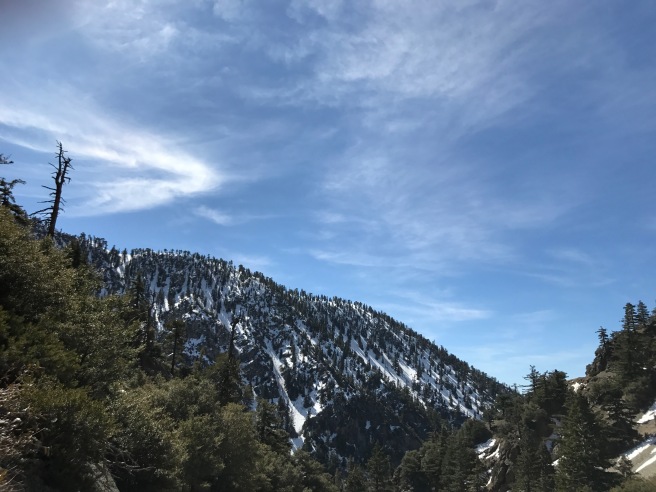
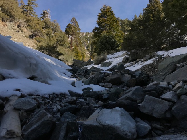
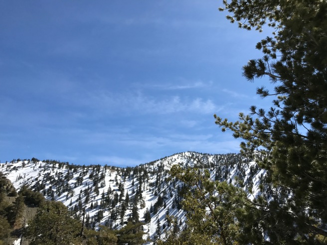
This was back in March, by the way. Last year’s winter was a wet one but the season was winding down and I’d still not been in the snow and so I went there one late winter day with my friend Matt. This winter, so far, has been bone dry, more characterized by wildfire storms than snow, but February is typically the wettest month so I wait to turn with fingers crossed.

At 3,068 meters tall, Mount San Antonio is both the highest peak in the San Gabriel Mountains and in Los Angeles County and one that marks the border between Los Angeles and the Inland Empire. I’m guessing that a larger number of Angelenos can tell you that Wilshire Grand Center is the “tallest building west of the Mississippi” [and, erm, east of Shanghai] — although I prefer to think if it as the 55th tallest building in the world. A moderately sized mountain like Mount San Antonio may not be the tallest mountain west of the Mississippi — but at 3,068 meters, it’s still 9.15 times taller than that skyscraper — and taller than all skyscrapers, for that matter.
Its nickname, Mount Baldy, was purportedly first coined by American settlers, who coined it to describe the largely treeless, steeply-sloped southern face of the mountain, also known as Baldy Bowl. The mountain actually has two peaks — the other is the 3,044-meter tall sub-peak, West Baldy. The northern face drains into Lytle Creek and the Fish Fork of the San Gabriel River. The southern face is drained by San Antonio Creek, which plunges through a canyon and down several waterfalls. To the east is Mount Harwood (named after the first female president of the Sierra Club, Aurelia Harwood) and the two meet at Baldy Notch, in the narrow pass which separates them, Devil’s Backbone. South of the mountain is Mt. Baldy Village. To the north is the town of Wrightwood, located on Wright Mountain.

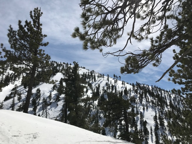
The lower areas of Mount San Antonio are dominated by yellow pine forest, which includes within it lodgepole pine, Jeffrey pine (also known as western yellow pine), white fir, and sugar pine. At slightly higher elevations, limber pine can be found growing in the chapparal and oak savannah. Higher still the only conifers are lodgepole pine which is joined by manzanita and bush chinquapin. The unforested subalpine zone begins around an elevation of 2,900 meters. Other flora found on the mountain include buckwheat, California Mustard, gray Monardella, mountain gooseberry, mountain whitethorn, Nuttall’s sandwort, parish’s bedstraw, Parry’s pussypaws, pumice alpinegold, purple mountain parsley, rockcress, Ross’s sedge, and San Gabriel alumroot.
Non-human animals found on Mount San Antonio include black bears, black-tailed jackrabbits, bobcats, California ground squirrels, coyotes, desert cottontails, desert bighorn sheep, eagles, hawks, lodgepole chipmunks, Merriam’s chipmunks, mule deer, opossums, pumas, raccoons, rattlesnakes, skunks, and Western gray squirrels. California Grizzly bears, though once common, were driven into extinction in the late 19th century although the West Hollywood-based Center for Biological Diversity is promoting their reintroduction to the state.
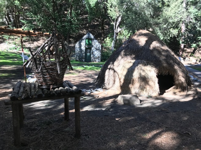
The Tongva call the mountain Yoát or Joat, which means snow. The Mohave know it as Avii Kwatiinyam. Ignoring both pre-existing names, the Spanish christened it Mount San Antonio, after Saint Anthony of Padua (né Fernando Martins de Bulhões). Mormon settlers founded Lytle Creek Canyon in 1851. In 1859, Victor Beaudry and Damien Marchessault built an icehouse next to a tributary of San Antonio Creek, in what came to be known as Icehouse Canyon. Ice was formerly brought from there to Los Angeles by mule cart and used at Beaudry and Marchessault’s their Ice Cream Saloon where they sold both iced wine and ice cream. Orange grower Madison Kincaid settled on the mountain in 1865. A sawmill was build in 1870 but was destroyed by either fire or flood in 1884. Fruit farmer and beekeeper A.A. Dexter arrived around 1875. Before long, however, tree harvesters, ice peddlers, fruit growers, and beekeepers would be all outnumbered by miners in search of gold, and those who would profit from their (in most cases) fruitless search for it.
A former sheep hunter, Fred Dell, established Dell’s Camp near what’s now Mt. Baldy Village and sold supplies to miners who came to the mountain in search of gold, as did mule driver Fletcher Manker, who opened shop at Manker Flat. In 1879, a prospector man named Jacob Skinner died in his mine on the Hog Back slide. In 1882, the San Antonio Water Company took over water rights in San Antonio Canyon. Gold mining began at Ice House Canyon in 1892. In 1893, the Hocumac Mine (aka Banks Mine) was built near Baldy Notch. In 1897, the Gold Ridge Diggings (aka Agamemnon Mine) was established near the headwaters of San Antonio Canyon.
The mountain never yielded much gold and as that became increasingly clear, the focus of many shifted to exploiting its recreational potential. Additionally, water pollution lawsuits filed by downriver farmers cut into what little profitability there was for miners hoping to get rich. A surveying party made the first recorded ascent in 1875, via Lytle Creek. William B. Dewey began leading hikes to the summit via Mt. Baldy Trail and Devil’s Backbone Trail. In 1880, brother-in-law of railroad baron Collis Potter Huntington, W.H. Stoddard, built a resort in Stoddard Canyon. Frank Keyes converted the focus of Dell’s Camp from mining support to resort rental. Rental cabins were also built in Evey Canyon. Dell’s Camp, too, began hosting visitors around the turn of the century. The growth of recreation brought resort operators into conflict with the San Antonio Water Company.
In 1899, a brush fire led to the pollution of the watershed and the water company responded by buying — and closing — Dell’s Camp. They also closed off the canyon with locked gates and stationed armed guards to keep out would-be visitors. Nevertheless, increasing numbers of visitors flocked to the mountain and new camps were built. In 1907, Charles Baynham built one near the former site of Dell’s Camp. Shortly afterward, the water company seems to have realized that there’s was a losing fight — and that there was money to be made. They purchased Baynham’s camp and kept him on to manage it — although they renamed it Campy Baldy in 1910.
In 1908, the first automobiles arrived. Baynham, working for the water company, charged a toll for the road from then until 1922. The area became part of a national forest in 1908, at which time the forest service began leasing plots of land in Icehouse Canyon for vacation cabins. By 1938, there were 105 such cabins and more at a resort opened by the Chapman family. The water company, too, began charging for lots at Camp Baldy and Manker Flat.
Dewey, the man who’d early on offered guided hikes up the mountain, built the Baldy Summit Inn in 1910 which, despite the grandness of its name consisted of little more than some tents and storage facilities. After a cooking fire damaged the “inn” in 1913, it was abandoned. By the 1920s there were several camps and proper resorts, though, including the Icehouse Canyon Resort, Bea Canyon Resort, Eleven Oaks, Baynham Camp, Alpine Woods, Trail Inn, Snow Crest, and Kelly’s Camp.
Relatively isolated, Prohibition wasn’t strictly enforced on the mountain. Foster and Ruth Curry, along with actor Edmund Burns (The Ordeal of Rosetta, A Very Good Young Man, The Love Burglar, To Please One Woman, The Lavender Bath Lady, Jazzmania, The Dramatic Life of Abraham Lincoln, The Princess from Hoboken, Tanned Legs, One Night at Susie’s, Hell-Bent for Frisco, Miss Fane’s Baby Is Stolen) transformed Camp Baldy into a posh playground for the wealthy with the addition of a swimming pool, dance pavilion, and casino. A lodge was built in 1930 at Manker Flats for Sierra Club members. In 1935, the Sierra Club built the “ski hut” near the headwaters of San Antonio Creek. It burned down soon after but was replaced with a structure that still stands. The Civilian Conservation Corps built a trail along the Devil’s Backbone from Mt. Baldy Notch to the summit from 1935–1936.
The Los Angeles flood of 1938, which led to the Los Angeles River being paved, also killed 113-115 people and destroyed almost all of the structures in Camp Baldy and Icehouse Canyon. The surviving structures at Icehouse Canyon were destroyed in a possible incident of arson in 1988. The San Antonio Dam was built from 1952-1956, to provide flood protection for the Santa Ana River system, and the reservoir behind the dam is usually dry.
The hotel at Camp Baldy was spared both floods and fires and is today known as Buckhorn Lodge. Camp Baldy was rebuilt and renamed Mt. Baldy Village. The Sugar Pine Chair Lift was built in 1952 (and renovated in 1975). A zen center opened at Manker Flats in 1971. When the 99-year leases on the cabins at Icehouse Canyon, Mt. Baldy Village, and Manker Flats ended, they passed to private owners. Today, Mt. Baldy Lodge continues to serve the public, as does Top of the Notch Restaurant & Ski Lodge, to which he hiked via a fire road and where we ate lunch. As we walked up the fire road, I vaguely recalled having walked that same route before, some fifteen years earlier, in a warmer season when there was no snow and the lodge and restaurant had been closed. Thankfully it was open when we arrived and after a moderately strenuous walk, a sweater was sufficiently warm and we enjoyed some beer, the snow, and the breathtaking views.

Unfortunately, to get to Mount San Antonio you’ll probably need to drive at least part of the way unless you’re a hardcore adventurer. The closest train station is Montclair Transcenter, located some 18 kilometers to the south, and 628 meters closer to sea level. Unfortunately, there’s no tram from there to the base of the mountain and several Omnitrans bus transfers are more trouble than they’re worth. Once at the mountain, however, the summit can be reached via trails on four sides of the mountain or by sky life. If walking is too slow, each Labor Day since 1965, the San Antonio Canyon Town Hall sponsors a “Run to the Top.”
FURTHER READING
Mt. Baldy, part of the Images of America series, by Kimberly J. Creighton (2009)

Probably the most detailed histories of Baldy I have ever read! I will admit to being guilty of thinking Mt SAC (Mt San Antonio College) when you first bought the name up until you mentioned “Baldy.” They host a lot of events on the mountain in the evening I keep meaning to attend… Also, sunblock alone never works! Time to get a hiking hat! Cover up! I wear a hat, bandana around my neck, sun glasses and usually long sleeves with UPC for protection from the sun. I keep a “packable/ crushable ” hat and Adventure Pass (I believe you can buy one at Manker Flats… something to mention to your readers to support our our underfunded park services) in the car for impromptu hikes. REI is probably my favorite place to shop! It has been a warm winter! I don’t believe there has been snow on Baldy yet which is unusual.
LikeLiked by 1 person
I bought a hat last year expressly for hiking… in the year since, I’ve only remembered to wear it once. I’m really absent-minded, unfortunately.
LikeLike
I keep one in the car because I forget if I don’t.
LikeLike
I’m not sure if there’s enough water to keep them running, but there are three hydro electric plants on San Antonio Creek. One of them is near the site of the first, which went on line around 1892, and was built by a company headed by the then-president of Pomona College. It was one of the first power stations in California to use AC technology and sent power down the hill to Claremont. I’m writing this from memory–if you want more info I can look it up in my copy of the history of Southern Calif. Edison.
LikeLike